Capulin, New Mexico | |
|---|---|
Census-designated place | |
 Capulin  Capulin | |
| Coordinates: 36°44′56″N103°59′45″W / 36.74889°N 103.99583°W | |
| Country | United States |
| State | New Mexico |
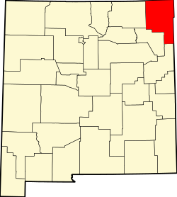
| County | Union |
| Area | |
• Total | 1.48 sq mi (3.84 km2) |
| • Land | 1.48 sq mi (3.84 km2) |
| • Water | 0 sq mi (0.00 km2) |
| Elevation | 6,824 ft (2,080 m) |
| Population | |
• Total | 61 |
| • Density | 41.1/sq mi (15.87/km2) |
| Time zone | UTC-7 (Mountain (MST)) |
| • Summer (DST) | UTC-6 (MDT) |
| ZIP code | 88414 |
| Area code | 575 |
| GNIS feature ID | 2584068 [2] |
Capulin is a census-designated place and unincorporated community in Union County, New Mexico, United States. Its population was 66 as of the 2010 census. Capulin had a post office until August 13, 2011; it still has its own ZIP code, 88414. [4] [5] U.S. routes 64 and 87 pass through the community.