The name Seowoncheon is also applied to the portion of the Jungnangcheon which separates Seoul from Gyeonggi Province.
The Jungnangcheon is a tributary of Seoul's Han River. It is generated in the valley of Dorak Mountain of Yangju, Gyeonggi-do. Cheonggyecheon is a tributary of Jungnangcheon. Its whole river basin extends to 299.9 km². Most of the stream is located in Uijeongbu and Seoul.
Seoul, officially the Seoul Special City, is the capital and largest metropolis of South Korea. With surrounding Incheon metropolis and Gyeonggi province, Seoul forms the heart of the Seoul Capital Area. Seoul is ranked as the fourth largest metropolitan economy in the world and is larger than London and Paris.
A stream is a body of water with surface water flowing within the bed and banks of a channel. The stream encompasses surface and groundwater fluxes that respond to geological, geomorphological, hydrological and biotic controls.
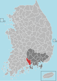
Cheongdo County (Cheongdo-gun) is a county in North Gyeongsang Province, South Korea. It is connected to the national transportation grid by the Gyeongbu Line railroad and the Daegu-Busan Expressway. The seat of government is located in the center of the county, in Hwayang-eup.
South Korea, officially the Republic of Korea (ROK), is a country in East Asia, constituting the southern part of the Korean Peninsula and lying to the east of the Asian mainland. The name Korea is derived from Goguryeo which was one of the great powers in East Asia during its time, ruling most of the Korean Peninsula, Manchuria, parts of the Russian Far East and Inner Mongolia, under Gwanggaeto the Great. South Korea lies in the north temperate zone and has a predominantly mountainous terrain. It comprises an estimated 51.4 million residents distributed over 100,363 km2 (38,750 sq mi). Its capital and largest city is Seoul, with a population of around 10 million.
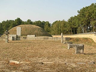
Seowon were the most common educational institutions of Korea during the mid- to late Joseon Dynasty. They were private institutions, and combined the functions of a Confucian shrine and a preparatory school. In educational terms, the seowon were primarily occupied with preparing students for the national civil service examinations. In most cases, seowon served only pupils of the aristocratic yangban class.
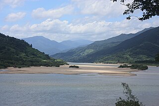
The Seowoncheon is best known for the Cheongdo Bullfighting Festival, which is held once a year on its broad and sandy banks.
South Korea is located in East Asia, on the southern half of the Korean Peninsula jutting out from the far east of the Asian landmass. The only country with a land border to South Korea is North Korea, lying to the north with 238 kilometres (148 mi) of border running along the Korean Demilitarized Zone. South Korea is mostly surrounded by water and has 2,413 kilometres (1,499 mi) of coastline along three seas; to the west is the Yellow Sea, to the south is the East China Sea, and to the east is the Sea of Japan. Geographically, South Korea's land mass is approximately 100,032 square kilometres (38,623 sq mi). 290 square kilometres (110 sq mi) of South Korea are occupied by water. The approximate coordinates are 37° North, 127° 30 East.
A geographic coordinate system is a coordinate system that enables every location on Earth to be specified by a set of numbers, letters or symbols. The coordinates are often chosen such that one of the numbers represents a vertical position and two or three of the numbers represent a horizontal position; alternatively, a geographic position may be expressed in a combined three-dimensional Cartesian vector. A common choice of coordinates is latitude, longitude and elevation. To specify a location on a plane requires a map projection.
This article related to a river in South Korea is a stub. You can help Wikipedia by expanding it.
South Gyeongsang Province is a province in the southeast of South Korea. The provincial capital is at Changwon. It is adjacent to the major metropolitan center and port of Busan. There is UNESCO World Heritage Site Haeinsa, a Buddhist temple that houses the Tripitaka Koreana and attracts many tourists. Automobile and petrochemical factories are largely concentrated along the southern part of the province, extending from Ulsan through Busan, Changwon, and Jinju.
Andong is a city in South Korea, and the capital of North Gyeongsang Province. It is the largest city in the northern part of the province with a population of 167,821 as of October 2010. The Nakdong River flows through the city. Andong is a market centre for the surrounding agricultural areas.
Sangju is a city in North Gyeongsang Province, South Korea. Although Sangju is rather rural, it is very old and was once a key city. Along with Gyeongju, it gives rise to half of the name of the Gyeongsang provinces. Sangju is nicknamed Sam Baek, or "Three Whites", referring to three prominent agricultural products rice, silkworm cocoons, and dried persimmons from the area.
Miryang, often spelled Milyang, is a city in Gyeongsangnam-do Province, South Korea. Neighboring cities include Changnyeong to the west, Cheongdo to the north, Ulsan to the east, and Yangsan, Gimhae, and Changwon to the south. The city bird is the Korean magpie, the city tree is the pine, and the city flower is the royal azalea.
Hadong County (Hadong-gun) is a county in South Gyeongsang Province, South Korea.
The Nakdong River or Nakdonggang is the longest river in South Korea, and passes through major cities such as Daegu and Busan. It takes its name from its role as the eastern border of the Gaya confederacy during Korea's Three Kingdoms Era.
Mungyeong Saejae is a mountain pass in central South Korea. It lies on Joryeong Mountain between the main peak (1017 m) and Sinseon Peak (967 m). The pass itself rises to 642 metres (2,106 ft) above sea level. Mungyeong Saejae connects Mungyeong City, North Gyeongsang province with Goesan County in North Chungcheong province. Water flowing down from the Mungyeong side of the pass eventually flows into the Nakdong River and meets the Sea of Japan at Busan. Runoff from the Goesan side eventually flows into the Han River, which passes through Seoul to meet the Yellow Sea at Incheon.
The Yeong River is a river in Mungyeong City, North Gyeongsang province, South Korea. It flows into the Nakdong River, which in turn flows into the Sea of Japan. The river rises from Hwabuk-myeon in Sangju, and drains most of western Mungyeong and parts of northern Sangju. From tip to tail, it covers a total of 66.2 km² and drains an area of 913.7 km². The Yeong flows into the Nakdong at the southeastern corner of Mungyeong between Yeongsun-myeon and Sangju's Sabeol-myeon.
The Geumho River flows through North Gyeongsang Province, South Korea, and drains into the Nakdong River. It rises in the hilly area of western Pohang, flows west for 116 kilometers before its meeting with the Nakdong in western Daegu. It drains an area of more than 2,000 square kilometers. Notable tributaries include the Sincheon, which flows north through Daegu. The name Geumho-gang means "river of the zither-shaped lake," a reference to its oxbow curve in northern Daegu. Much of the riverbank in Daegu has been transformed into parkland.
The Hwang River is a tributary of the Nakdong River, flowing through Gyeongsangnam-do in southeastern South Korea. It originates in Geochang, from the union of various streams flowing from the slopes of Deogyusan, and meets the Nakdong in Hapcheon County. It covers about 117 kilometers. The name literally means "yellow," and refers to the yellow sand found along much of the river's course.
Gaeun is an eup in Mungyeong, Gyeongsangbuk-do, South Korea. It was formerly a center of coal-mining, but the last mines closed in the 1990s. The dominant local industries are now tourism and agriculture. There are also several operating kilns.
Iseo-myeon is a myeon, or township, in western Cheongdo County, Gyeongsangbuk-do, South Korea. It borders Daegu on the north. It is connected to both Daegu and central Cheongdo by Local Highway 30, which crosses under the Paljoryeong pass as it descends from Daegu to its terminus in Gangnam-myeon. Iseo-myeon is composed of 17 ri.
Paljoryeong is a mountain pass in southeastern South Korea, lying between the peaks of Bonghwasan and Sangwonsan, which are both slightly over 660 meters high. The pass itself is slightly less than 400 metres (1,300 ft) above sea level. It lies on the border of modern-day Daegu metropolitan city and Cheongdo, Gyeongsangbuk-do province. At one time it was the major overland route between Daegu and the region to its south. The north side of the pass is in Daegu, in Gachang-myeon, Dalseong-gun. The south side is in Cheongdo's Iseo-myeon.
The Miryang River is a tributary of the Nakdong River which flows through Miryang City. It rises in Ulsan metropolitan city, on the slopes of Gohyeonsan, and flows for 101.5 kilometers before joining the Nakdong in Miryang's Samnangjin-eup. Its narrower upper reaches are often called the Miryangcheon, or "Miryang Stream."
Gachang-myeon is a myeon, or township in rural southeastern Daegu, South Korea. Part of Dalseong County, it is separated from the urban center of Daegu by the ridgelines of Yongjibong and Apsan. These two mountains are separated by the narrow valley of the Sincheon, a tributary of the Nakdong which drains most of the township. The valley of the Sincheon also hosts the only roads that connect Gachang to central Daegu.
The Seomjin River is a river in South Korea. It drains southeastern Jeollabuk-do as well as eastern Jeollanam-do and western Gyeongsangnam-do provinces, and flows into the Korea Strait. The Seomjin rises from Palgongsan and flows for 212.3 kilometers before reaching its final destination in Gwangyang, where it enters Gwangyang Bay.
Sosu Seowon is the oldest seowon, private Neo-Confucian academy in Korea which was established during the Joseon Dynasty period. It was found at the entrance of Suksusa Temple, in Sunheung-myeon, Yeongju City, Gyeongsangbuk-do South Korea. Sosu Seowon was founded by Ju Sebung, who was serving as magistrate of Pungseong county.
The Tarlo River, a perennial river that is part of the Hawkesbury-Nepean catchment, is located in the Southern Tablelands and Southern Highlands regions of New South Wales, Australia.
This page is based on this Wikipedia article Text is available under the CC BY-SA 4.0 license; additional terms may apply. Images, videos and audio are available under their respective licenses.