Cheongdo County

Last updated
Cheongdo
청도군
Korean transcription(s)
  Hangul청도군
  Hanja
  Revised RomanizationCheongdo-gun
  McCune-ReischauerCh'ŏngdo-gun
Korea-2006 Cheongdo Bullfighting Festival-01.jpg
Cheongdo County is famous for its annual bullfighting festival
Flag of Cheongdo.svg
Cheongdo logo.png
North Gyeongsang-Cheongdo.svg
Location in South Korea
CountryFlag of South Korea.svg  South Korea
Region Yeongnam
Administrative divisions 2 eup, 7 myeon
Area
  Total696.53 km2 (268.93 sq mi)
Population
 (2005)
  Total47,099
  Density72.8/km2 (189/sq mi)
  Dialect
Gyeongsang
Bohyeonsa Buddha Statue Korea-Cheongdo County-Bohyeonsa-Buddha statue-01.jpg
Bohyeonsa Buddha Statue

Cheongdo County (Cheongdo-gun) is a county in North Gyeongsang Province, South Korea. It is connected to the national transportation grid by the Gyeongbu Line railroad and the Daegu-Busan Expressway. The seat of government is located in the center of the county, in Hwayang-eup.

Contents

In the Samhan period, Cheongdo may have been the site of the small polity of Ieso-guk. It was later absorbed into Silla, and gained its current name of "Cheongdo" in 940. The county's nine subdivisions were established in 1919. The county government moved to its current location in 1961. In 1966, the New Village Movement began in Sindo 1-ri, Cheongdo-eup.

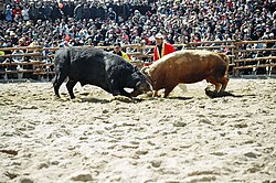
Every year Cheongdo is host to an international bullfighting festival.

The slogan for Cheongdo is "Singgreen Cheongdo."

Administrative divisions

Cheongdo is divided into two eup and seven myeon, as below. These in turn are divided into 212 ri, and 668 natural villages (jayeon burak).

Map of Cheongdo County in Korean Map of Chengdo, South Korea.png
Map of Cheongdo County in Korean
NameHangeulHanja
Hwayang-eup화양읍華陽邑
Cheongdo-eup청도읍淸道邑
Gakbuk-myeon각북면角北面
Punggak-myeon풍각면豊角面
Iseo-myeon 이서면伊西面
Gangnam-myeon각남면角南面
Maejeon-myeon 매전면梅田面
Geumcheon-myeon 금천면錦川面
Unmun-myeon 운문면雲門面

Twin towns – sister cities

Cheongdo is twinned with:

Festivals

Culture

Museums

Monuments

Parks

experiences

Other important spots

Architecture

Historical

Foreigners

As Cheongdo is a small town, with a population that is just over 50,000, there is not a high number of foreigners. However, there are a few foreigners that are living there as English teachers through the EPIK Program. Unfortunately, it is very rare to come across a local Cheongdo resident that speaks English. Learning basic Korean is an essential for living in Cheongdo.

Climate & Weather

Much like the rest of Korea, Cheongdo has four distinct seasons. Summers in Cheongdo can be extremely hot as Cheongdo is only 30 minutes away from Daegu by train. Daegu is known to be one of the hottest cities in South Korea, due to the surrounding mountains that trap all the heat.

Winters can be rather cold, reaching -15 degrees Celsius on occasion. Furthermore, the air is extremely dry during the winter time.

Both Autumn and Spring are rather mild, no extreme weather conditions for either. However, during Spring, typically in April, the air quality is very poor. It is very common to see locals protecting themselves with face masks against the "yellow dust."

Climate data for Cheongdo (1993–2020 normals)
MonthJanFebMarAprMayJunJulAugSepOctNovDecYear
Mean daily maximum °C (°F)6.1
(43.0)
8.8
(47.8)
14.3
(57.7)
20.4
(68.7)
25.6
(78.1)
28.4
(83.1)
30.3
(86.5)
31.2
(88.2)
26.8
(80.2)
21.9
(71.4)
15.1
(59.2)
8.0
(46.4)
19.7
(67.5)
Daily mean °C (°F)−1.1
(30.0)
1.6
(34.9)
6.9
(44.4)
12.9
(55.2)
18.2
(64.8)
22.1
(71.8)
25.5
(77.9)
25.7
(78.3)
20.6
(69.1)
14.1
(57.4)
7.2
(45.0)
0.8
(33.4)
12.9
(55.2)
Mean daily minimum °C (°F)−6.8
(19.8)
−4.5
(23.9)
0.3
(32.5)
5.9
(42.6)
11.4
(52.5)
16.9
(62.4)
21.6
(70.9)
21.7
(71.1)
16.2
(61.2)
8.2
(46.8)
1.0
(33.8)
−5.0
(23.0)
7.2
(45.0)
Average precipitation mm (inches)20.1
(0.79)
29.7
(1.17)
57.0
(2.24)
85.7
(3.37)
95.1
(3.74)
138.1
(5.44)
243.6
(9.59)
255.4
(10.06)
163.3
(6.43)
54.1
(2.13)
34.4
(1.35)
20.4
(0.80)
1,196.9
(47.12)
Average precipitation days (≥ 0.1 mm)3.43.86.37.47.88.112.511.58.24.34.23.180.6
Source: Korea Meteorological Administration [1]

See also

Related Research Articles

<span class="mw-page-title-main">Yeongju</span> Municipal City in Yeongnam, South Korea

Yeongju is a city in the far north region of North Gyeongsang province in South Korea, covering 668.84 km2 with a population of 113,930 people according to the 2008 census. The city borders Bonghwa county to the east, Danyang county of North Chungcheong province to the west, Andong city and Yecheon county to the south, and Yeongwol county of Gangwon province to the north.

<span class="mw-page-title-main">Danyang County</span> County in Hoseo, South Korea

Danyang County is in North Chungcheong Province, South Korea.

<span class="mw-page-title-main">Muju County</span> County in Honam, South Korea

Muju County (Muju-gun), is a county in North Jeolla Province (Jeollabuk-do), South Korea. Muju is known for its Muju Firefly Festival and is a tourist area.

<span class="mw-page-title-main">Gyeongju</span> Municipal City in North Gyeongsang Province, South Korea

Gyeongju, historically known as Seorabeol, is a coastal city in the far southeastern corner of North Gyeongsang Province, South Korea. It is the second largest city by area in the province after Andong, covering 1,324 km2 (511 sq mi) with a population of 264,091 people as of December 2012. Gyeongju is 370 km (230 mi) southeast of Seoul, and 55 km (34 mi) east of Daegu. The city borders Cheongdo and Yeongcheon to the west, Ulsan to the south and Pohang to the north, while to the east lies the coast of the Sea of Japan. Numerous low mountains—outliers of the Taebaek range—are scattered around the city.

South Korea is made up of 17 first-tier administrative divisions: 6 metropolitan cities, 1 special city, 1 special self-governing city, and 9 provinces, including two special self-governing provinces. These are further subdivided into a variety of smaller entities, including cities, counties, districts, towns, townships, neighborhoods and villages.

<span class="mw-page-title-main">Cheonan</span> Specific city in Hoseo, South Korea

Cheonan is the largest and most densely populated city of Chungcheongnam-do, South Korea, and the third largest city in the Hoseo region after Daejeon and Cheongju. Cheonan borders Gyeonggi-do in the north, Chungcheongbuk-do to the east and southeast, Sejong City to the south and Asan-si and Gongju-si to the west and southwest.

<span class="mw-page-title-main">Mungyeong</span> Municipal City in Yeongnam, South Korea

Mungyeong is a city in North Gyeongsang Province, South Korea. The local government, economy, and transportation networks are all centered in Jeomchon, the principal town. Mungyeong has a lengthy history, and is known today for its various historic and scenic tourist attractions. The city's name means roughly "hearing good news." Recently, development has been somewhat stagnant with the decline of the coal industry. Since the 1990s, the proportion of people who rely on the tourism industry through Mungyeong Saejae has gradually increased.

<span class="mw-page-title-main">Bonghwa County</span> County in Yeongnam, South Korea

Bonghwa County (Bonghwa-gun) is a county in North Gyeongsang Province, South Korea. It lies inland, at the northern edge of the province, and borders Gangwon province to the north. To the east it is bounded by Yeongyang and Uljin counties, to the south by Andong, and to the west by Yeongju. The county is ringed by the Taebaek and Sobaek Mountains, the highest of which is Taebaeksan (1,566.7m). Because of its mountainous location, Bonghwa has a colder climate than most of the province, with an average annual temperature of 10 °C (50 °F).

<span class="mw-page-title-main">Seongju County</span> County in Yeongnam, South Korea

Seongju County (Seongju-gun) is a county in North Gyeongsang Province, South Korea. This largely agricultural area is located immediately west of the metropolitan city of Daegu. The capital of the county is the town of Seongju.

<span class="mw-page-title-main">Uiseong County</span> County in Yeongnam, South Korea

Uiseong County (Uiseong-gun) is a county in Gyeongsangbuk-do Province, South Korea. Located near the center of the province, it is bounded by Andong on the north, Cheongsong on the east, Gunwi County on the south, and Sangju and Yecheon on the west. As in most parts of Korea, most of the land is vacant and forested; only about 19% of the county's area is farmland. The county is largely rural, with an economy dominated by agriculture; the only urbanized area is the county seat, Uiseong-eup.

<span class="mw-page-title-main">Ulleung County</span> County in North Gyeongsang, South Korea

Ulleung County is a county in North Gyeongsang Province, South Korea.

<span class="mw-page-title-main">Miryang</span> Municipal City in Yeongnam, South Korea

Miryang, formerly also spelled as 推火郡, Milbeol (密伐) and Milseong (密城), is a city in Gyeongsangnam-do Province, South Korea. Its name is originated from the tribal country named Miri midong guk (彌離彌凍國). There are various hypotheses as to the meaning of Miryang, such as Milky Way, Galaxy, dragon's field, The Wheat Field and the watery field. Neighboring cities include Changnyeong to the west, Cheongdo to the north, Ulsan to the east, and Yangsan, Gimhae, and Changwon to the south. The city bird is the Korean magpie, the city tree is the pine, and the city flower is the royal azalea.

<span class="mw-page-title-main">Geochang County</span> County in Yeongnam, South Korea

Geochang County is a county in South Gyeongsang Province, South Korea. The Geochang International Festival of Theater, which was started in 1989, is renowned as the best play festival in Korea. The District Office is located in Geochang-eup, and has jurisdiction over 1 eup and 11 myeon.

<span class="mw-page-title-main">Haman County</span> County in Yeongnam, South Korea

Haman County (Haman-gun) is a county in South Gyeongsang Province, South Korea. The local government is seated in Gaya-eup. The county magistrate is Seok Gyu Jin.

<span class="mw-page-title-main">Buk District, Daegu</span> Autonomous District in Yeongnam, South Korea

Buk District is a district in northwestern Daegu, South Korea. It adjoins Chilgok County on the north. The area is 93.99 km². The population is about 444,923.

<span class="mw-page-title-main">Dong District, Daegu</span> Autonomous District in Yeongnam, South Korea

Dong District is a gu (district) in northeastern part of Daegu metropolitan city of South Korea. Daegu city itself lies in the southeastern part of Korean Peninsula. It has a population of 343,678. The district covers 182.35 km², for about 20% of Daegu's total area.

Iseo-myeon is a myeon, or township, in western Cheongdo County, Gyeongsangbuk-do, South Korea. It borders Daegu on the north. It is connected to both Daegu and central Cheongdo by Local Highway 30, which crosses under the Paljoryeong pass as it descends from Daegu to its terminus in Gangnam-myeon. Iseo-myeon is composed of 17 ri.

<span class="mw-page-title-main">Dalseong County</span> County in Yeongnam, South Korea

Dalseong County (Dalseong-gun) is a gun occupying much of south and western Daegu, South Korea. A largely rural district lying along the Nakdong River, it makes up nearly half of Daegu's total area. It is divided in half by a narrow piece of Dalseo-gu that reaches west to the river.

<span class="mw-page-title-main">Daegok station (Daegu Metro)</span> Station of the Daegu Metro

Daegok Station is an underground of the first line of Daegu city railroad in Daegok-dong in Dalseo-gu, Daegu, South Korea. It is located on the boundary between Dalseo-gu Daegok-dong and Dalseong-gun Hwawon-eup Gura-ri. There are an exit and entrance for a Hwawon-eup Bolli-ri Bolli-jigu Bolli Greenvill. A southern extension into Dalseong-gun (county) was opened on September 8, 2016.

<span class="mw-page-title-main">Ulju County</span> County in Yeongnam, South Korea

Ulju County is a county occupying much of western Ulsan, South Korea.

References

  1. "Climatological Normals of Korea (1991 ~ 2020)" (PDF) (in Korean). Korea Meteorological Administration. Archived from the original (PDF) on 29 January 2022. Retrieved 7 June 2023.

35°38′50″N128°44′03″E / 35.647253°N 128.734088°E / 35.647253; 128.734088