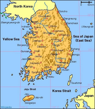
South Korea is located in East Asia, on the southern portion of the Korean Peninsula located out from the far east of the Asian landmass. The only country with a land border to South Korea is North Korea, lying to the north with 238 kilometres (148 mi) of the border running along the Korean Demilitarized Zone. South Korea is mostly surrounded by water and has 2,413 kilometres (1,499 mi) of coast line along three seas; to the west is the Yellow Sea, to the south is the East China Sea, and to the east is the Sea of Japan. Geographically, South Korea's landmass is approximately 100,032 square kilometres (38,623 sq mi). 290 square kilometres (110 sq mi) of South Korea are occupied by water. The approximate coordinates are 37° North, 128° East.

South Gyeongsang Province is a province in the southeast of South Korea. The provincial capital is at Changwon. It is adjacent to the major metropolitan center and port of Busan. The UNESCO World Heritage Site Haeinsa, a Buddhist temple that houses the Tripitaka Koreana and tourist attraction, is located in this province. Automobile and petrochemical factories are largely concentrated along the southern part of the province, extending from Ulsan through Busan, Changwon, and Jinju.

The Bagmati River flows through the Kathmandu valley of Nepal, separating the cities of Kathmandu and Patan, before flowing through Madesh Province of southern Nepal and joining the Kamla River in the Indian state of Bihar. It is considered holy by both Hindus and Buddhists. A number of Hindu temples are located on its banks.

The Fox River is a river in eastern Wisconsin in the Great Lakes region of the United States. It is the principal tributary of Green Bay, and via the Bay, the largest tributary of Lake Michigan. The city of Green Bay, one of the first European settlements in the interior of North America, is on the river at its mouth on lower Green Bay.

The Feather River is the principal tributary of the Sacramento River, in the Sacramento Valley of Northern California. The river's main stem is about 73 miles (117 km) long. Its length to its most distant headwater tributary is just over 210 miles (340 km). The main stem Feather River begins in Lake Oroville, where its four long tributary forks join—the South Fork, Middle Fork, North Fork, and West Branch Feather Rivers. These and other tributaries drain part of the northern Sierra Nevada, and the extreme southern Cascades, as well as a small portion of the Sacramento Valley. The total drainage basin is about 6,200 square miles (16,000 km2), with approximately 3,604 square miles (9,330 km2) above Lake Oroville.

The Calapooya Mountains are a mountain range in Lane and Douglas counties of southwestern Oregon in the United States. The range runs for approximately 60 miles (97 km) west from the Cascade Range between Eugene on the north and Roseburg on the south.
Sangju is a city in North Gyeongsang Province, central South Korea. Although Sangju is rather rural, it is very old and was once a key city. Along with Gyeongju, it gives rise to half of the name of the Gyeongsang provinces. Sangju is nicknamed Sam Baek, or "Three Whites", referring to three prominent agricultural products rice, silkworm cocoons, and dried persimmons from the area.

Miryang, formerly also spelled as 推火郡, Milbeol (密伐) and Milseong (密城), is a city in Gyeongsangnam-do Province, South Korea. Its name is originated from the tribal country named Miri midong guk (彌離彌凍國). There are various hypotheses as to the meaning of Miryang, such as Milky Way, Galaxy, dragon's field, The Wheat Field and the watery field. Neighboring cities include Changnyeong to the west, Cheongdo to the north, Ulsan to the east, and Yangsan, Gimhae, and Changwon to the south. The city bird is the Korean magpie, the city tree is the pine, and the city flower is the royal azalea.

The Nakdong River or Nakdonggang is the longest river in South Korea, which passes through the major cities of Daegu and Busan. It takes its name from its role as the eastern border of the Gaya confederacy during Korea's Three Kingdoms Era.
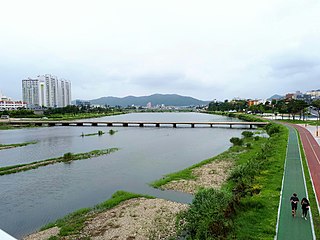
The Geumho River flows through North Gyeongsang Province, South Korea, and drains into the Nakdong River. It rises in the hilly area of western Pohang, flows west for 116 kilometers before meeting with the Nakdong in western Daegu. It drains an area of more than 2,000 square kilometers. Notable tributaries include the Sincheon, which flows north through Daegu. The name Geumho-gang means "river of the zither-shaped lake," a reference to its oxbow curve in northern Daegu. Much of the riverbank in Daegu has been transformed into parkland.
Karamana is a river flowing through the city of Thiruvananthapuram in Kerala, India. The river starts near the southern tip of the Western Ghats(Sahyadri Mountains) at Agastyar Koodam. The river flows 66 km westward and merges with the Arabian sea at Panathura near Kovalam. The river gets its name from Karamana, a suburb of Thiruvananthapuram city, through which it flows.
The name Seowoncheon is also applied to the portion of the Jungnangcheon which separates Seoul from Gyeonggi Province.

Paljoryeong is a mountain pass in southeastern South Korea, lying between the peaks of Bonghwasan and Sangwonsan, which are both slightly over 660 meters high. The pass itself is slightly less than 400 metres (1,300 ft) above sea level. It lies on the border of modern-day Daegu metropolitan city and Cheongdo, Gyeongsangbuk-do province. At one time it was the major overland route between Daegu and the region to its south. The north side of the pass is in Daegu, in Gachang-myeon, Dalseong-gun. The south side is in Cheongdo's Iseo-myeon.
Cheontaesan (Korean: 천태산) is a 631-meter-high mountain in Gyeongsangnam-do, South Korea, on the border between Miryang and Yangsan cities. It lies near the southern end of the Yeongnam Alps, and looks south across the Nakdong River to Gimhae. Cheontaesan is connected to Geumosan to its north.

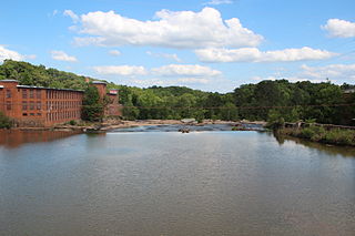
The Yeongnamnu or Yeongnamru is a pavilion on a cliff overlooking the curve of the Miryang River in central Miryang, Gyeongsangnam-do, South Korea. It dates to the Joseon Dynasty and is one of the central cultural treasures of Miryang. The current structure was built in 1884 according to the design of then-magistrate Yi In-jae. During the Joseon period, this was known as one of the three great pavilions of Korea, together with the Chokseongnu in Jinju and the Pubyŏk pavilion in Pyongyang.
Samnangjin or Samnangjin-eup, is an eup, or town, in Miryang City, Gyeongsangnam-do, South Korea. It is composed of thirteen ri. Samnangjin lies in the southeastern corner of Miryang, bordering Wondong-myeon in Yangsan City.
The Yellow River is a 76-mile-long (122 km) tributary of the Ocmulgee River in the U.S. state of Georgia.
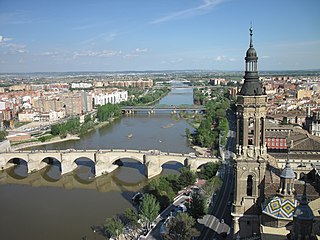
The Ebro is a river of the north and northeast of the Iberian Peninsula, in Spain. It rises in Cantabria and flows 930 kilometres (580 mi), almost entirely in an east-southeast direction. It flows into the Mediterranean Sea, forming a delta in the Province of Tarragona, in southern Catalonia. In the Iberian peninsula, it ranks second in length after the Tagus and second in discharge volume, and drainage basin, after the Douro. It is the longest river entirely within Spain; the other two mentioned flow into Portugal. It is also the second-longest river in the Mediterranean basin, after the Nile.
The Cadoxton River is a short river in the Vale of Glamorgan, South Wales and with a length of about 5 miles/8 kilometres it is one of Wales's shortest rivers.
Pollution in Korea has become diversified and serious due to rapid industrialization and urbanization since the 1960s. The causes of environmental pollution, both in South and North Korea, can be found in population growth, urban concentration, and industrial structure, similar to the rest of the world.