Related Research Articles

North Yorkshire is a ceremonial county in Northern England. It borders County Durham to the north, the North Sea to the east, the East Riding of Yorkshire to the south-east, South Yorkshire to the south, West Yorkshire to the south-west, and Cumbria and Lancashire to the west. The largest settlement is Middlesbrough.

The West Riding of Yorkshire is one of three historic subdivisions of Yorkshire, England. From 1889 to 1974 the administrative county County of York, West Riding (the area under the control of West Riding County Council), abbreviated County of York (WR), was based closely on the historic boundaries. The lieutenancy at that time included the City of York and as such was named West Riding of the County of York and the County of the City of York.
Cumberland is a historic county in North West England, covering part of the Lake District as well as the northern Pennines and the coast of Solway Firth. Cumberland had an administrative function from the 12th century until 1974, when it was subsumed into Cumbria, a larger administrative area which also covered Westmorland and parts of Yorkshire and Lancashire. In April 2023, Cumberland was revived as an administrative entity when Cumbria County Council was abolished and replaced by two unitary authorities, one of which is named Cumberland and includes most of the historic county, with the exception of Penrith and the surrounding area.
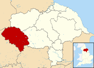
Craven was a non-metropolitan district in the west of North Yorkshire, centred on the market town of Skipton.

The North Riding of Yorkshire is a subdivision of Yorkshire, England, alongside York, the East Riding and West Riding. The riding's highest point is at Mickle Fell at 2,585 ft (788 m).

Settle is a market town and civil parish in the Craven district of North Yorkshire, England. Historically in the West Riding of Yorkshire, the town had a population of 2,421 in the 2001 Census, increasing to 2,564 at the 2011 Census.

The Borough of East Yorkshire was one of nine local government districts of the county of Humberside, England, from 1 April 1974 to 1 April 1996.

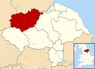
The Borough of Harrogate was a local government district with borough status in North Yorkshire, England. On 31 March 2023 it was abolished and on 1 April 2023 its functions were transferred to the new North Yorkshire Council.

Austwick is a village and civil parish in the Craven district of North Yorkshire, England, about 5 miles (8 km) north-west of Settle. The village is on the edge of the Yorkshire Dales National Park.

The Borough of Boothferry was, from 1 April 1974 to 1 April 1996, a local government district with borough status within the non-metropolitan county of Humberside. The district is now split between the East Riding of Yorkshire and North Lincolnshire.

Ribblesdale is one of the Yorkshire Dales in England. It is the dale or upper valley of the River Ribble in North Yorkshire. Towns and villages in Ribblesdale include Selside, Horton-in-Ribblesdale, Stainforth, Langcliffe, Giggleswick, Settle, Long Preston and Hellifield. Below Hellifield the valley of the river is generally known as the Ribble Valley.
Long Preston is a village and civil parish in the Craven district of North Yorkshire, England, in the Yorkshire Dales. It lies along the A65 road, and is 12 miles (19 km) from Skipton and 4 miles (6 km) from Settle. The population of Long Preston in 2001 was 680, increasing to 742 at the 2011 Census.
Doncaster was a rural district in the West Riding of Yorkshire, England from 1894 to 1974.
West Craven is an area in the east of Lancashire, England in the far northern part of the borough of Pendle. Historically the area was within the ancient county boundaries of Yorkshire and was administered as part of the Skipton Rural District of the West Riding of Yorkshire until 1974.


Settle Town Hall is a municipal building in Cheapside in Settle, North Yorkshire, England. The structure, which was the meeting place of Settle Rural District Council, is a Grade II listed building.
References
- ↑ "No, Settle, you can't have your civic chain back, says district council". Craven Herald and Pioneer. 12 February 2010. Retrieved 23 July 2013.
- ↑ Page, William, ed. (1907). The Victoria history of the county of York. vol 3. London: Constable & Co. p. 540. OCLC 500092527.
- ↑ "Administrative unit Settle RD Local Government District". visionofbritain.org.uk. Retrieved 19 August 2023.
- ↑ Census 1971 England and Wales: report for the West Riding of Yorkshire Part I. London: HMSO. 1973. p. 3. ISBN 0-11-690367-8.