
Transportation planning is the process of defining future policies, goals, investments, and designs to prepare for future needs to move people and goods to destinations. As practiced today, it is a collaborative process that incorporates the input of many stakeholders including various government agencies, the public and private businesses. Transportation planners apply a multi-modal and/or comprehensive approach to analyzing the wide range of alternatives and impacts on the transportation system to influence beneficial outcomes.
The Research Triangle Regional Public Transportation Authority, known as GoTriangle, provides regional bus service to the Research Triangle region of North Carolina in Wake, Durham, and Orange counties. The GoTriangle name was adopted in 2015 as part of the consolidated GoTransit branding scheme for the Triangle.

The National Environmental Policy Act (NEPA) is a United States environmental law that promotes the enhancement of the environment and established the President's Council on Environmental Quality (CEQ). The law was enacted on January 1, 1970. To date, more than 100 nations around the world have enacted national environmental policies modeled after NEPA.
An environmental impact statement (EIS), under United States environmental law, is a document required by the 1969 National Environmental Policy Act (NEPA) for certain actions "significantly affecting the quality of the human environment". An EIS is a tool for decision making. It describes the positive and negative environmental effects of a proposed action, and it usually also lists one or more alternative actions that may be chosen instead of the action described in the EIS. Several U.S. state governments require that a document similar to an EIS be submitted to the state for certain actions. For example, in California, an Environmental Impact Report (EIR) must be submitted to the state for certain actions, as described in the California Environmental Quality Act (CEQA). One of the primary authors of the act is Lynton K. Caldwell.
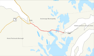
The Glenn Highway is a highway in the U.S. state of Alaska, extending 179 miles (288 km) from Anchorage near Merrill Field to Glennallen on the Richardson Highway. The Tok Cut-Off is often considered part of the Glenn Highway, for a total length of 328 miles (528 km).
The Seward Highway is a highway in the U.S. state of Alaska that extends 125 miles (201 km) from Seward to Anchorage. It was completed in 1951 and runs through the scenic Kenai Peninsula, Chugach National Forest, Turnagain Arm, and Kenai Mountains. The Seward Highway is numbered Alaska Route 9 (AK-9) for the first 37 miles (60 km) from Seward to the Sterling Highway and AK-1 for the remaining distance to Anchorage. At the junction with the Sterling Highway, AK-1 turns west towards Sterling and Homer. About eight miles (13 km) of the Seward Highway leading into Anchorage is built to freeway standards. In Anchorage, the Seward Highway terminates at an intersection with 5th Avenue, which AK-1 is routed to, and which then leads to the Glenn Highway freeway.

The Port of Alaska (POA) is a deep-water port located in Anchorage, Alaska with 3 bulk carrier berths, two petroleum berths, and one barge berth. It is an enterprise department of the Municipality of Anchorage. The name was changed from "Port of Anchorage" to the "Port of Alaska" in 2017. As such, the Port is distinguished from other types of municipal departments largely because it generates enough revenue to support its operations without being a burden to Anchorage property tax payers, and it also pays a fee-in-lieu of taxes to help run city government.

Environmental assessment (EA) is the assessment of the environmental consequences of a plan, policy, program, or actual projects prior to the decision to move forward with the proposed action. In this context, the term "environmental impact assessment" (EIA) is usually used when applied to actual projects by individuals or companies and the term "strategic environmental assessment" (SEA) applies to policies, plans and programmes most often proposed by organs of state. It is a tool of environmental management forming a part of project approval and decision-making. Environmental assessments may be governed by rules of administrative procedure regarding public participation and documentation of decision making, and may be subject to judicial review.
Anchorage was originally settled as a tent city near the mouth of Ship Creek in 1914, a townsite was platted the following year alongside the bluff to the south. Anchorage was mostly a company town for the Alaska Railroad for its first several decades of existence.
The Northern Branch Corridor Project is a planned extension of the Hudson-Bergen Light Rail (HBLR) from its northern terminus into eastern Bergen County, New Jersey, initially proposed in 2001. If built, the new service would use the right-of-way of the Northern Branch on which the Erie Lackawanna Railroad ran passenger service until October 3, 1966, and is currently a lightly used, stub-ended freight rail line owned by CSX Transportation. The Northern Branch Corridor is at the foot of the west side of the Hudson Palisades in the Hackensack River valley, running for much of its length parallel to Overpeck Creek. After mixed reactions and extensive community input to a draft environmental impact statement (EIS), it was decided in 2013 to terminate the line at the Englewood Hospital and Medical Center. In March 2017 the Supplementary Draft Environmental Impact Statement was approved by the Federal Transit Administration allowing for a period of public reaction. A separately conceived and funded bridge at 69th St. in North Bergen necessary for operation of the system has been compeleted. NJ Transit estimates that the line will open in 2029.
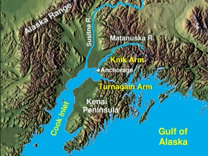
The Knik Arm Bridge is a dormant proposal for a 1.74-mile (2.80 km) bridge across Cook Inlet's Knik Arm to link the two fastest growing parts of Alaska – Anchorage and the Matanuska-Susitna Borough.
Context-sensitive solutions (CSS) is a theoretical and practical approach to transportation decision-making and design that takes into consideration the communities and lands through which streets, roads, and highways pass. The term is closely related to but distinguishable from context-sensitive design in that it asserts that all decisions in transportation planning, project development, operations, and maintenance should be responsive to the context in which these activities occur, not simply the design process. CSS seeks to balance the need to move vehicles efficiently and safely with other desirable outcomes, including historic preservation, environmental sustainability, and the creation of vital public spaces. In transit projects, CSS generally refers to context sensitive planning, design, and development around transit stations, also known as transit-oriented development.

The Lynn Canal Highway, or Juneau Access Road, is a proposed road between Skagway and City and Borough of Juneau, the capital of the U.S. state of Alaska. Such a road, if built, would still require ferry access to connect Juneau to the Alaskan highway network. The new road would be 47.9 miles long, built at a cost of $574 million, and be a part of Alaska Route 7. The plan of the Alaska Department of Transportation & Public Facilities (DOT&PF) called for extending "The Road" northward from Juneau to a ferry terminal 18 miles south of Skagway. The corridor crosses Berners Bay LUD II which is a congressionally designated roadless area created by the Tongass Timber Reform Act (TTRA). The act permits crossing LUD IIs when the governor of the State of Alaska designates routes as essential transportation corridors. The proposed road skirts the shore of a northwestern section of Alaska's Inside Passage, which was recently named a National Scenic Waterway. As of 2017, the project has been indefinitely shelved due to the state's budget crisis.
Alaska Route 1 (AK-1) is a state highway in the southern part of the U.S. state of Alaska. It runs from Homer northeast and east to Tok by way of Anchorage. It is the only route in Alaska to contain significant portions of freeway: the Seward Highway in south Anchorage and the Glenn Highway between Anchorage and Palmer.

The following outline is provided as an overview of and topical guide to the U.S. state of Alaska:

Seward's Success was a planned community proposed for Point MacKenzie, north of Anchorage, Alaska, United States. The megaproject was to be fully enclosed by a dome spanning the Knik Arm and holding a community of 40,000 residents, with ample residential, office, recreational and commercial space. It was proposed in 1968 after the discovery of oil at Prudhoe Bay and scuttled in 1972 by a delay to the development of the Trans-Alaska Pipeline System.
The Portage Glacier Highway, or Portage Glacier Road, is a highway located in the U.S. state of Alaska. The highway is made up of a series of roads, bridges, and tunnels that connect the Portage Glacier area of the Chugach National Forest and the city of Whittier to the Seward Highway. Most of the highway travels through mainly rural areas just north of the Kenai Peninsula, with the Anton Anderson Memorial Tunnel passing under Maynard Mountain, part of the Chugach Mountain Range. Parts of the route were first constructed in the early 1900s, and the entire highway was completed on June 7, 2000, as part of the Whittier Access Project. As of 2012, the highway has not been extended or rerouted. The main portion of the highway traveling from the western terminus to the Begich, Boggs visitors center is designated as National Forest Highway 35 by the United States Forest Service (USFS).
The Minnesota Drive Expressway is a 7.560 miles (12.167 km) long south-north expressway located in the city of Anchorage, Alaska, United States. The expressway includes a small portion of O'Malley Road, which is also built to expressway standards. The highway travels from the southern region of Anchorage northward to North Star neighborhood area, and bisects the community of Spenard. The first section of the highway was constructed around 1950, and the entire highway was upgraded to expressway standards by the year of 1985. The entire length of the expressway is listed on the National Highway System, a network of roads important to the country's economy, defense, and mobility.
The Responsibly And Professionally Invigorating Development Act of 2013 is a bill that would aim to expedite the review process required by the National Environmental Policy Act (NEPA) for construction projects that are partly or fully financed with federal funds or require permits or approvals from federal regulatory agencies. It was to do so by establishing specific deadlines for environmental reviews, which sometimes go on so long that they can delay a project for years.