
The Tre Cime di Lavaredo, also called the Drei Zinnen ; pronounced[ˌdʁaɪˈtsɪnən] ), are three distinctive battlement-like peaks, in the Sexten Dolomites of northeastern Italy. They are one of the best-known mountain groups in the Alps. The three peaks, from east to west, are:

Tofane is a mountain group in the Dolomites of northern Italy, west of Cortina d'Ampezzo in the province of Belluno, Veneto. Most of the Tofane lie within the Ampezzo Dolomites Natural Park.

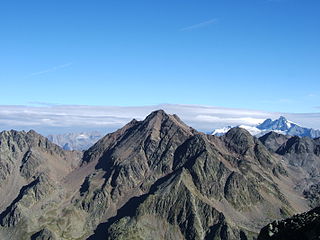
Cristallo is a mountain massif in the Italian Dolomites, northeast of Cortina d'Ampezzo, in the province of Belluno, Veneto, northern Italy. It is a long, indented ridge with four summits higher than 3,000 metres. The mountain range is part of the Ampezzo Dolomites Natural Park.
The Sentiero Ferrato Ivano Dibona is a challenging high alpine route along the Zurlon ridge, the main crest on Cristallo, a mountain group in the Italian Dolomites, northeast of Cortina d'Ampezzo, in the province of Belluno, Veneto, Italy. The use of a via ferrata set is recommended. The via ferrata is very well known because of the dolomitic scenery and the panoramic view.

The Birkenkofel is a mountain in the Sexten Dolomites in South Tyrol, Italy.

The Cima Undici - Elferkofel is a mountain in the Sexten Dolomites in South Tyrol, Italy.

The Helm is a mountain in the Puster Valley in South Tyrol, Italy.

The Haunold is a mountain in the Dolomites in South Tyrol, Italy.
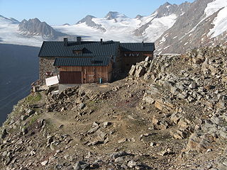
The Karlesspitze or Grubspitze is a mountain in the Schnalskamm group of the Ötztal Alps on the border between Tyrol, Austria, and South Tyrol, Italy.
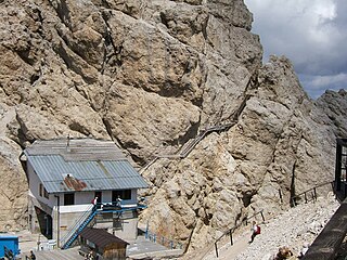
The Paterno is a mountain in the Dolomites on the border between South Tyrol and the Province of Belluno, Italy.

The Vajolet towers are six summits in the Dolomites between the Fassa Valley and the Tiers Valley, on the border between the Trentino and South Tyrol in Italy.

The Mittagstal is a cirque in the Sella group in South Tyrol, Italy.
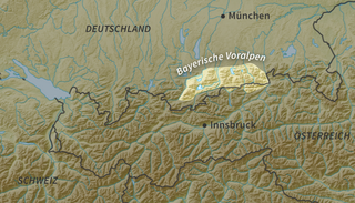
The Bavarian Prealps are a mountain range within the Northern Limestone Alps along the Austria–Germany border. They include the Bavarian Prealp region between the river Loisach to the west and the river Inn to the east; the range is about 80 kilometres (50 mi) long and 20–30 kilometres (12–19 mi) wide. The term is not defined politically, but alpine-geographically because, although the range is mostly located in Bavaria, southeast Germany, small areas of the Bavarian Prealps lie in the state of Tyrol, Austria.

The Durier Hut is a mountain hut in the Mont Blanc massif of the Alps. It is located in Haute-Savoie department of France on the French/Italian border at an altitude of 3358 m.
The Alpine Club Guides were the standard series of alpine climbing guidebookss that cover all the important mountain groups in the Eastern Alps. They were produced jointly by the German (DAV), Austrian (ÖAV) and South Tyrol Alpine Clubs (AVS). They had been published since 1950 by the firm of Bergverlag Rother in Munich, Germany.

Angelo Dibona was an Austro-Hungarian and Italian mountaineer. He is remembered as one of the great pioneers of climbing in the Dolomites and is responsible for many first ascents throughout the Alps. The Aiguille Dibona in France, the Campanile Dibona and the Dibona-Kante on the Cima Grande di Lavaredo are named after him.
The Hochschober is the mountain that gives its name to the Schober Group in the High Tauern, although the summit is only the fourth highest in the group. This may have arisen because the north face of the mountain is an impressive sight from Kals.

The Rauhkofel or Rauchkofel is a summit on the main crest of the Zillertal Alps, which forms the border between the Austrian state of Tyrol and the Italian province of South Tyrol. The name of the mountain comes from the rugged appearance of the granite blocks that form the summit. The Rauhkofel rises above its neighbouring peaks on the main Zillertal ridge considerably and it is considered the best lookout mountain in the eastern Zillertal Alps. The east and south arêtes of the Rauhkofel are part of the main crest of the Zillertal Alps. Another ridge runs from the summit heading northwest; on its continuation at a distance of just under two kilometres is the Kleinspitze. North of the summit are the remnants of the Rauhkofelkees glacier. At the southwestern foot of the peak is the Waldner See, the largest lake in the Ahrntal valley.

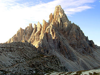
The Piz Popena is a mountain in the Dolomites of Auronzo and Misurina, located in Veneto. It culminates at 3,152 metres (10,341 ft), and belongs to the Cristallo group.

