
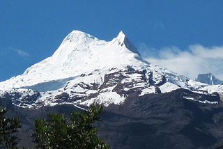
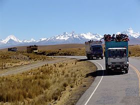
Huantsán,Huantsan or Tunsho is a mountain in the Andes of Peru. It is located in Ancash Region and is part of the Cordillera Blanca mountain range, a sub-range of the Andes. It has four peaks, with a maximum elevation of 6,369 metres (20,896 ft) above sea level.

Ocshapalca is a mountain in the Cordillera Blanca in the Andes of Peru, about 5,888 m (19,318 ft) high. It is situated in the Ancash Region, Huaraz Province, on the border of the districts Independencia District and Tarica. Ocshapalca lies between the mountain Hatunkunka in the west and Ranrapalca in the east.

Tocllaraju is a mountain in the Cordillera Blanca in the Andes of Peru, about 6,034 m (19,797 ft) high. It is situated in the Ancash Region, Carhuaz Province, Aco District, and in the Huaraz Province, Tarica District. Tocllaraju lies north-west of the mountains Pukaranra and Palcaraju.

Cashan, Kashan or Tijeraspunta is a mountain in the Cordillera Blanca in the Andes of Peru, about 5,716 metres (18,753 ft) high. It is located in the Ancash Region, Huaraz Province, in the districts of Huaraz and Olleros. Cashan lies southeast of the town of Huaraz, southwest of Huantsán, west of Uruashraju and northeast of Shacsha.
Vallunaraju or Wallunaraju is a mountain in the Cordillera Blanca in the Andes of Peru, about 5,686 metres (18,655 ft) high and located in Huaraz Province, Ancash. Vallunaraju lies south west of Ranrapalca and Ocshapalca.
Huamashraju,Wamashraju,, Yanahuacra or Rajo Colta is a mountain in the Cordillera Blanca in the Andes of Peru, about 5,434 metres (17,828 ft) high. It is situated in the Ancash Region, Huaraz Province, Huaraz District. Huamashraju lies east of the town of Huaraz, west of Huantsán and northwest of Shacsha and Cashan.

Urus, also known as Yanaraju, is a 5,423-metre-high (17,792 ft) mountain in the Cordillera Blanca in the Andes of Peru. It located between Carhuaz and Huaraz provinces, in Ancash. Urus lies in Huascarán National Park, west of Tocllaraju.
Quitaraju or Kitaraju is a mountain in the Cordillera Blanca in the Andes of Peru, about 6,040 metres (19,816 ft) high. It is situated in the Ancash Region, Huaylas Province, Santa Cruz District. Quitaraju lies north of the Santa Cruz Creek and the lakes named Ichiccocha, Jatuncocha and Quitacocha, between Santa Cruz in the west and Alpamayo in the northeast.

Tullparaju is a mountain in the Cordillera Blanca in the Andes of Peru, about 5,787 metres (18,986 ft) high. It is situated in the Ancash Region, Huaraz Province, Independencia District, and in the Huari Province, Huari District. Tullparaju lies southeast of the mountains Pucaranra and Chinchey and northeast of Andavite. It is situated at the end of the Quilcayhuanca valley, northeast of the lake Tullpacocha.
Churup or Tsurup is a mountain in the Cordillera Blanca in the Andes of Peru, about 5,495 metres (18,028 ft) high. It is situated in the Ancash Region, Huaraz Province, Independencia District, north-east of Huaraz. Churup is situated south of the mountain Ranrapalca, between the Rima Rima in the north-west and Collapaco and Huamashraju in the south-east, at the entrance to the Quilcayhuanca valley. Lake Churup lies at the foot of the mountain.
Uruashraju or Verdecocha is a mountain in the Cordillera Blanca of the Andes of Peru, about 5,722 metres (18,773 ft) high. It is located in the Ancash Region, Huaraz Province, Olleros District, and in the Huari Province, Chavín de Huantar District. Uruashraju lies south of Huantsán, east of Cashán and Shacsha, and southeast of Lake Tararhua.
Carhuascancha or Tumarinaraju is a mountain in the Cordillera Blanca in the Andes of Peru with an elevation of 5,648 metres (18,530 ft) or 5,668 metres (18,596 ft) above sea level. It is situated in the Ancash Region, Huari Province, Huantar District, and in the Huaraz Province, Huaraz District. Carhuascancha lies north-west of Huantsán.
Jatuncunca, Janyaraju or Jangyraju is a mountain in the Cordillera Blanca of the Andes of Peru, about 5,600 metres (18,373 ft) high. It is located in the Ancash Region, Huaraz Province, on the border of the districts Independencia and Tarica. Jatuncunca lies west of Ocshapalca.

Pucagaga Punta or Pucagaga is a mountain in the Cordillera Blanca in the Andes of Peru, 5,461 metres (17,917 ft) high. It is situated in the Ancash Region, Huaraz Province, Independencia District, northeast of Huaraz. Pucagaga lies south of Ranrapalca, next to Churup, northeast of it.
Tuctopunta is a 5,343-metre-high (17,530 ft) mountain in the Cordillera Blanca in the Andes of Peru. It is located in the Ancash Region, Huaraz Province, Olleros District. Tuctopunta lies northwest of Tuctu and southwest of Uruashraju and Arhuay.
Rúrec, also spelled Rurec, is a 5,700-metre-high (18,701 ft) mountain in the southern part of the Cordillera Blanca in the Andes of Peru. It is located in the Ancash Region, Huaraz Province, Olleros District, and in the Huari Province, Chavín de Huantar District. Rúrec is located south of Huantsán.
Andavite or Chopiraju is a 5,518-metre-high (18,104 ft) mountain in the Cordillera Blanca in the Andes of Peru. It is located northeast of the village of Pitec, between Huaraz and Huari provinces in Ancash. Andavite lies northwest of Cayesh and southeast of Tullparaju. It is situated at the end of the Quilcayhuanca valley, southeast of a lake named Tullpacocha.
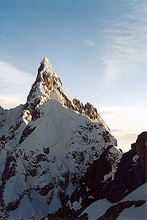
Cayesh is a mountain in the Cordillera Blanca in the Andes of Peru, about 5,721 metres (18,770 ft) high. It is located between Huaraz and Huari provinces in Ancash. Cayesh lies at the head of the Cayesh valley, northwest of Artisa and southeast of Andavite.
Maparaju is a 5,326-metre-high (17,474 ft) mountain in the Cordillera Blanca in the Andes of Peru. It is located between Huaraz and Huari provinces, in the region of Ancash. Maparaju lies at the head of the Cayesh valley, southwest of Cayesh and Artisa and northeast of Qarwakancha.
Quimarumi, also known as Minas, is a 5,459-metre-high (17,910 ft) mountain in the Cordillera Blanca in the Andes of Peru. It is located in the Ancash Region, Huaraz Province, Huaraz District. Quimarumi lies on a ridge between the Quilcayhuanca valley and the Shallap valley, northwest of Carhuascancha and northeast of Qullapaqu.

