The Trumpeter Islets comprise a group of two unpopulated islets, with a combined area of about a hectare, located close to the south-western coast of Tasmania, Australia. Situated some 6 kilometres (3.7 mi) where the mouth of Port Davey meets the Southern Ocean, the 1-hectare (2.5-acre) island is part of the Trumpeter Islets Group, and comprises part of the Southwest National Park and the Tasmanian Wilderness World Heritage Site.
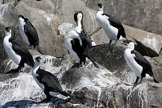
Egg Island is a small island, with an area of 0.97 ha, in south-eastern Australia. It is part of the North Coast Group, lying in Bass Strait on Horseshoe Reef near Devonport in north-west Tasmania. It has been identified as an Important Bird Area (IBA) because of its globally significant colony of black-faced cormorants. Wright Island is nearby.

The Gull Island, part of the Passage Group within the Furneaux Group, is an 8.5-hectare (21-acre) granite island, located in Bass Strait southeast of Cape Barren Island, in Tasmania, in south-eastern Australia. The island is a conservation reserve and with the Passage and Forsyth islands, the Gull Island forms part of the Forsyth, Passage and Gull Islands Important Bird Area (IBA), identified as such by BirdLife International because it supports over 1% of the world populations of little penguins and black-faced cormorants.

The Forsyth Island, part of the Passage Group within the Furneaux Group, is a 167-hectare (410-acre) granite island, located in Bass Strait south of Cape Barren Island, in Tasmania, in south-eastern Australia. With the Passage and Gull islands, the Forsyth Island forms part of the Forsyth, Passage and Gull Islands Important Bird Area (IBA), identified as such by BirdLife International because it supports over 1% of the world populations of little penguins and black-faced cormorants.

Night Island is a small granite island, with an area of 2.59 ha, is part of the Preservation Island Group, lying in eastern Bass Strait south of Cape Barren Island in the Furneaux Group, Tasmania, Australia.

The Big Black Reef, part of the Long Island Group within the Furneaux Group, is a 0.54-hectare (1.3-acre) unpopulated small, flat dolerite island, located in Bass Strait, lying west of Cape Barren Island, Tasmania, in south-eastern Australia.
Boxen Island is a flat dolerite island, with an area of 7 ha, in south-eastern Australia. It is part of Tasmania’s Long Island Group, lying in eastern Bass Strait west of Cape Barren Island in the Furneaux Group. Together with nearby Big Black Reef it is classified by BirdLife International as an Important Bird Area because it has been recorded as supporting 288 breeding pairs of black-faced cormorants.

The North West Mount Chappell Islet, part of the Badger Group within the Furneaux Group, is a 7,100-square-metre (76,000 sq ft) unpopulated mainly granite islet, in Bass Strait, lying west of the Flinders and Cape Barren islands, Tasmania, south of Victoria, in south-eastern Australia. The island is located within a conservation area and is part of the Chalky, Big Green and Badger Island Groups Important Bird Area.
The Little Goose Island, part of the Badger Group within the Furneaux Group, is a 3.6-hectare (8.9-acre) unpopulated flat, round granite island, located in Bass Strait, lying west of the Flinders and Cape Barren islands, Tasmania, south of Victoria, in south-eastern Australia. The island is contained within a nature reserve and is part of the Chalky, Big Green and Badger Island Groups Important Bird Area.
The Beagle Island, part of the Badger Group within the Furneaux Group, is a 1.2-hectare (3.0-acre) unpopulated low, flat granite island, located in Bass Strait, lying west of the Flinders and Cape Barren islands, Tasmania, south of Victoria, in south-eastern Australia. The island is contained within a nature reserve and is part of the Chalky, Big Green and Badger Island Groups Important Bird Area.

Outer Sister Island, part of the Sister Islands Conservation Area, is a granite and dolerite island, with an area of 545 hectares (2.10 sq mi), located in Bass Strait, Tasmania, Australia.
The Little Chalky Island, part of the Big Green Group within the Furneaux Group, is a 5-hectare (12-acre) unpopulated granite island, located in the Bass Strait, west of the Flinders Island and south of Chalky Island, in Tasmania, in south-eastern Australia. The island is part of the Chalky, Big Green and Badger Island Groups Important Bird Area.

The Chalky Island, part of the Big Green Group within the Furneaux Group, is a 41-hectare (100-acre) unpopulated granite island with limestone outcrops and dolerite dykes, located in the Bass Strait, west of the Flinders Island, in Tasmania, in south-eastern Australia. The island is contained within a conservation area and is part of the Chalky, Big Green and Badger Island Groups Important Bird Area.
The Mile Island, part of the Big Green Group within the Furneaux Group, is a 4-hectare (9.9-acre) granite island, located in Bass Strait west of Flinders Island, in Tasmania, in south-eastern Australia. The island is partly contained within a conservation area; and is part of the Chalky, Big Green and Badger Island Groups Important Bird Area.
The Little Waterhouse Island, part of the Waterhouse Island Group, is a 2.5-hectare (6.2-acre) granite island situated in Banks Strait, part of Bass Strait, lying close to the north-eastern coast of Tasmania, Australia.
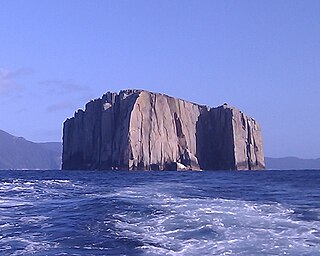
Hippolyte Rocks is a small granite island, with an area of 5.3 ha, in south-eastern Australia. It is part of the Tasman Island Group, lying close to the south-eastern coast of Tasmania around the Tasman Peninsula. It has a flat top and is surrounded by steep cliffs up to 65 m in height. It is part of the Tasman National Park.

South East Mutton Bird Islet is a steep unpopulated islet located close to the south-western coast of Tasmania, Australia. Situated 2 kilometres (1.2 mi) south of where the mouth of Port Davey meets the Southern Ocean, the 0.52-hectare (1.3-acre) islet is one of the eight islands that comprise the Mutton Bird Islands Group. The South East Mutton Bird Islet is part of the Southwest National Park and the Tasmanian Wilderness World Heritage Site.
Sugarmouse Island is an unpopulated islet located close to the south-western coast of Tasmania, Australia. Situated some 2 kilometres (1.2 mi) south of where the mouth of Port Davey meets the Southern Ocean, the 0.54-hectare (1.3-acre) islet is one of the eight islands that comprise the Mutton Bird Islands Group. Sugarmouse Island is part of the Southwest National Park and the Tasmanian Wilderness World Heritage Site.
The East Pyramids comprise a group of three steep, rocky unpopulated islets located close to the south-western coast of Tasmania, Australia. Situated some 2 kilometres (1.2 mi) south of where the mouth of Port Davey meets the Southern Ocean, the 6.69-hectare (16.5-acre) islets are one of the eight islands that comprise the Mutton Bird Islands Group. The East Pyramids are part of the Southwest National Park and the Tasmanian Wilderness World Heritage Site.
The Coffee Pot, also known simply as Coffee Pot, with a shape suggesting a coffee pot, is an unpopulated steep, rocky islet located close to the south-western coast of Tasmania, Australia. Situated some 2 kilometres (1.2 mi) northwest of where the mouth of Port Davey meets the Southern Ocean, the 0.31-hectare (0.77-acre) islet is part of the Trumpeter Islets Group, and comprises part of the Southwest National Park and the Tasmanian Wilderness World Heritage Site.