Related Research Articles

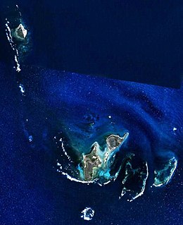
The Houtman Abrolhos is a chain of 122 islands, and associated coral reefs, in the Indian Ocean off the west coast of Australia, about eighty kilometres (50 mi) west of Geraldton, Western Australia. It is the southernmost true coral reef in the Indian Ocean, and one of the highest latitude reef systems in the world. It is one of the world's most important seabird breeding sites, and is the centre of Western Australia's largest single-species fishery, the western rock lobster fishery. It has a small seasonal population of fishermen, and a limited number of tourists are permitted for day trips, but most of the land area is off limits as conservation habitat. It is well known as the site of numerous shipwrecks, the most famous being the Dutch ships Batavia, which was wrecked in 1629, and Zeewijk, wrecked in 1727.
The Wallabi Group is the northernmost group of islands in the Houtman Abrolhos off the western coast of Western Australia. it is 58 kilometres from the Australian mainland, and about 9 kilometres from the Easter Group.

The Easter Group is the central of three groups of islands that make up the Houtman Abrolhos island chain. The group measures about 20 kilometres by 12 kilometres, and consists of a number of islands including

The Pelsaert Group is the southernmost of the three groups of islands that make up the Houtman Abrolhos island chain. it consists of a number of islands, the largest of which are Gun Island, Middle Island, and Pelsaert Island. The group is named after a Dutch "opperkoopman" who stranded nearby with the VOC-ship "Batavia" in 1629. The group contains the most southerly true coral reefs in the Indian Ocean. The group is part of the Houtman Abrolhos Important Bird Area, identified as such by BirdLife International because of its importance for supporting large numbers of breeding seabirds.

North Island is the northernmost island in the Houtman Abrolhos, a coral reef archipelago in the Indian Ocean off the coast of Mid West Western Australia. Located about 14 km (9 mi) from the nearest island group, it is one of the largest islands in the Houtman Abrolhos, and one of the few to support dune systems. It has relatively diverse flora dominated by chenopod shrubs and fauna that includes the introduced tammar wallaby, around seven species of reptile, and about 15 resident bird species.
South Passage is a 14 kilometre (9 mi) wide strait that separates the outlying North Island from other islands in the Wallabi Group of the Houtman Abrolhos island chain, in the Indian Ocean off the coast of Western Australia. It is nominally located at 28°21′14″S113°35′46″E.

North East Reef is a reef in the Wallabi Group of the Houtman Abrolhos, in the Indian Ocean off the coast of Western Australia. Located at 28°25′13″S113°48′41″E, it takes its name from the fact that it is situated to the north-east of the main body of islands that makes up the Wallabi Group. The island is part of the Houtman Abrolhos Important Bird Area, identified as such by BirdLife International because of its importance for supporting large numbers of breeding seabirds.

Fish Point is a point in the north-eastern corner of East Wallabi Island in the Houtman Abrolhos island chain off the coast of Western Australia. It is located at 28°25′40″S113°44′34″E. It sits at the foot of Flag Hill, the highest peak on East Wallabi Island, and its western edge looks out onto Turtle Bay.
Gun Island is one of the larger islands in the Pelsaert Group of the Houtman Abrolhos, in the Indian Ocean off the west coast of Australia. It is nominally at 28°53′10″S113°51′35″E, about 4 km (2.5 mi) north and east of Half Moon Reef and is a flat limestone outcrop of about 800 by 420 metres in size. The island is part of the Houtman Abrolhos Important Bird Area, identified as such by BirdLife International because of its importance for supporting large numbers of breeding seabirds.

The Abrolhos painted buttonquail is a subspecies of the painted buttonquail endemic to the Houtman Abrolhos. It is common on North Island, and also occurs on other islands of the Wallabi Group, namely East Wallabi, West Wallabi, Seagull and Pigeon Islands.
Flag Hill is the highest hill on East Wallabi Island, and the highest point in the Houtman Abrolhos, an archipelago off the coast of Western Australia. It is located in the north-east of the island; its gazetted location is 28°26′7″S113°44′14″E, but in fact it is located somewhat east of there at about 28°26′02″S113°44′18″E. It is about 15 metres (50 ft) high.
Wallabi Limestone is the name given to the dense calcretised, limestone platform that underlies the Wallabi Group of the Houtman Abrolhos, an archipelago off the coast of Western Australia. This platform, which arises abruptly from a flat shelf, is about 40 metres thick, and is of marine biogenic origin, having originated as a coral reef. It reached its maximum size during the Eemian Stage, when sea levels were higher than at present. The subsequent fall in sea level resulted in the reef becoming emergent in places, thus forming the basement of the group's "central platform" islands, namely West Wallabi Island, East Wallabi Island and North Island.
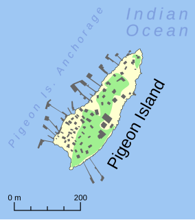
Pigeon Island is a small island located need the middle of the Wallabi Group of the Houtman Abrolhos, an archipelago off the coast of Western Australia. It is almost entirely given over to western rock lobster fishers' camps, and as a result is far more disturbed than most other islands in the archipelago. A nearby island also seasonally populated by fishers is named Little Pigeon Island, hence Pigeon Island is sometimes referred to as "Big Pigeon Island".
East Wallabi Island is an island in the Wallabi Group of the Houtman Abrolhos, located in the Indian Ocean off the west coast of mainland Australia.
West Wallabi Island is an island in the Wallabi Group of the Houtman Abrolhos, in the Indian Ocean off the west coast of mainland Australia.

Lindsay Boyd Collins was an Australian marine geologist and sedimentologist, a faculty member in the department of applied geology at Curtin University in Western Australia. He was interested in studying the continental shelf of Western Australia and coral reefs. Collins was a prominent scholar, he has completed projects on continental shelf mapping of Australian shelves, microbialites and seagrass banks at Shark Bay, and coral reef studies at the Abrolhos, Ningaloo, Scott Reef, the Rowley Shoals and the Kimberley.
Pelsaert Island is one of the islands of the Pelsaert Group, which is the southernmost of the three groups of islands that make up the Houtman Abrolhos island chain in Western Australia.
Beacon Island, also known as Batavia's graveyard, is an island on the eastern side of the Wallabi Group at the northern end of the Houtman Abrolhos, in the Indian Ocean, off the coast of Western Australia.
References
- ↑ Gazetteer of Australia (1996). Belconnen, ACT: Australian Surveying and Land Information Group.
- ↑ "Shag Rock". Gazetteer of Australia online. Geoscience Australia, Australian Government.
- ↑ Australia 1:100000 Topographic Survey, Map sheet 1641 (Edition 1): Wallabi
- 1 2 Harvey, Judith M. (2001). "A flora and vegetation survey of the islands of the Houtman Abrolhos, Western Australia". CALMScience. 3 (4): 521–623. Data also available in McCrea, Jo, ed. (October 2003). "Inventory of the Land Conservation Values of the Houtman Abrolhos Islands". Fisheries Management Papers (Fisheries Management Paper No. 151 ed.). Department of Fisheries, Government of Western Australia. ISSN 0819-4327 . Retrieved 2008-02-02.
- ↑ Collins, Lindsay B.; Zhu, Zhong Rong; Wyrwoll, Karl-Heinz (1998). "Late Tertiary-Quaternary Geological Evolution of the Houtman Abrolhos Carbonate Platforms, Northern Perth Basin". In Purcell, R.; Purcell, P. (eds.). The sedimentary basins of Western Australia. Vol. 2. Perth, Western Australia: Petroleum Exploration Society of Australia. pp. 647–663. Archived from the original on 2008-07-22. Retrieved 2008-05-02.
- ↑ Collins, Lindsay B.; Zhu, Zhong Rong; Wyrwoll, Karl-Heinz (2004). "Geology of the Houtman Abrolhos Islands". In Vacher, Leonard; Quinn, Terrence (eds.). Geology and hydrogeology of carbonate islands (Developments in Sedimentology 54) . Elsevier Science. pp. 811–834. ISBN 9780444516442.