
Punjab is a geopolitical, cultural, and historical region in South Asia, specifically in the northern part of the Indian subcontinent, comprising areas of eastern Pakistan and northwestern India. Punjab's major cities are Lahore, Faisalabad, Rawalpindi, Gujranwala, Multan, Ludhiana, Amritsar, Sialkot, Chandigarh, Shimla, Jalandhar, Gurugram, and Bahawalpur.

Punjab is one of the four provinces of Pakistan. Located in centraleastern region, Punjab is the second-largest province of Pakistan by land area and the largest province by population. It shares land borders with the Pakistani provinces of Khyber Pakhtunkhwa to the north-west, Balochistan to the south-west and Sindh to the south, as well as Islamabad Capital Territory to the north-west, Autonomous Territory of AJK to the north and International border with the Indian states of Rajasthan and Punjab to the east and Indian-administered Kashmir to the north-east. Punjab is the most fertile province of the country as River Indus and it's four major tributaries Ravi, Jhelum, Chenab and Sutlej flow through it.

Rajasthan is a state in northern India. It covers 342,239 square kilometres (132,139 sq mi) or 10.4 per cent of India's total geographical area. It is the largest Indian state by area and the seventh largest by population. It is on India's northwestern side, where it comprises most of the wide and inhospitable Thar Desert and shares a border with the Pakistani provinces of Punjab to the northwest and Sindh to the west, along the Sutlej-Indus River valley. It is bordered by five other Indian states: Punjab to the north; Haryana and Uttar Pradesh to the northeast; Madhya Pradesh to the southeast; and Gujarat to the southwest. Its geographical location is 23.3 to 30.12 North latitude and 69.30 to 78.17 East longitude, with the Tropic of Cancer passing through its southernmost tip.

Shivaji Bhonsale I, also referred to as Chhatrapati Shivaji Maharaj, was an Indian ruler and a member of the Bhonsle Maratha clan. Shivaji carved out his own independent kingdom from the declining Adilshahi sultanate of Bijapur which formed the genesis of the Maratha Empire. In 1674, he was formally crowned the Chhatrapati of his realm at Raigad Fort.

Sambhaji Bhosale was the second Chhatrapati of the Maratha Empire, ruling from 1681 to 1689. He was the eldest son of Shivaji, the founder of the Maratha Empire. Sambhaji's rule was largely shaped by the ongoing wars between the Maratha Empire and the Mughal Empire, as well as other neighbouring powers such as the Siddis, Mysore and the Portuguese in Goa. After Sambhaji's death, his brother Rajaram I succeeded him as the next Chhatrapati.
Kodungallur is a historically significant town situated on the banks of river Periyar on the Malabar Coast in Thrissur district of Kerala, India. It is 29 kilometres (18 mi) north of Kochi (Cochin) by National Highway 66 and 38 km (24 mi) from Thrissur. Kodungallur, being a port city at the northern end of the Kerala lagoons, was a strategic entry point for the naval fleets to the extensive Kerala backwaters.

Shekhawati is a semi-arid historical region located in the northeast part of Rajasthan, India. The region was ruled by Shekhawat Rajputs. Shekhawati is located in North Rajasthan, comprising the districts of Jhunjhunu, parts of Sikar that lies to the west of the Aravalis and Churu. It is bounded on the northwest by the Jangladesh region, on the northeast by Haryana, on the east by Mewat, on the southeast by Dhundhar, on the south by Ajmer, and on the southwest by the Marwar region. Its area is 13784 square kilometers.
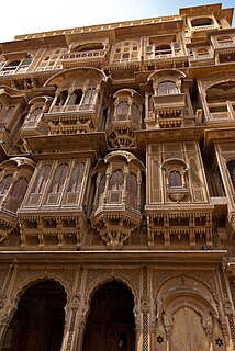
A haveli is a traditional townhouse, mansion, manor house, in the Indian subcontinent, usually one with historical and architectural significance, and located in a town or city. The word haveli is derived from Arabic hawali, meaning "partition" or "private space", popularised under the Mughal Empire, and was devoid of any architectural affiliations. Later, the word haveli came to be used as a generic term for various styles of regional mansions, manor houses, townhouse found in the Indian subcontinent.
Gahlot is a clan of Rajputs Guhilot Rajputs ruled number of Kingdom's including Mewar, Banswara, Dungarpur, Pratapgarh, Shahpura, Bhavnagar, Palitana, Lathi and Vala, The variations of the name include Gehlot, Guhila, Gohil or Guhilot.

Pune district is the most populous district in the Indian state of Maharashtra. The district's population was 9,429,408 in the 2011 census, making it the fourth most populous district amongst India's 640 districts. This district has an urban population of 58.08 percent of its total. It is one of the most industrialized districts in India. In recent decades it has also become a hub for information technology.

The Bundela is a Rajput clan. Over several generations, the cadet lineages of Bundela Rajputs founded several states in area what came to be known as Bundelkhand anciently known as Chedi Kingdom from the 16th century.
The term Kerala was first epigraphically recorded as Keralaputra (Cheras) in a 3rd-century BCE rock inscription by the Mauryan emperor Ashoka of Magadha. It was mentioned as one of four independent kingdoms in southern India during Ashoka's time, the others being the Cholas, Pandyas and Satyaputras. The Cheras transformed Kerala into an international trade centre by establishing trade relations across the Arabian Sea with all major Mediterranean and Red Sea ports as well those of Eastern Africa and the Far East. The dominion of Cheras was located in one of the key routes of the ancient Indian Ocean trade. The early Cheras collapsed after repeated attacks from the neighboring Cholas and Rashtrakutas.

Kerala is a state on the Malabar Coast of India. It was formed on 1 November 1956, following the passage of the States Reorganisation Act, by combining Malayalam-speaking regions of the erstwhile regions of Cochin, Malabar, South Canara, and Travancore. Spread over 38,863 km2 (15,005 sq mi), Kerala is the 21st largest Indian state by area. It is bordered by Karnataka to the north and northeast, Tamil Nadu to the east and south, and the Lakshadweep Sea to the west. With 33 million inhabitants as per the 2011 census, Kerala is the 13th-largest Indian state by population. It is divided into 14 districts with the capital being Thiruvananthapuram. Malayalam is the most widely spoken language and is also the official language of the state.

The Mughal Empire was an Islamic early-modern empire that controlled much of South Asia between the 16th and 19th centuries. For some two hundred years, the empire stretched from the outer fringes of the Indus river basin in the west, northern Afghanistan in the northwest, and Kashmir in the north, to the highlands of present-day Assam and Bangladesh in the east, and the uplands of the Deccan Plateau in South India.

The Bengal Subah, also referred to as Mughal Bengal, was the largest subdivision of the Mughal Empire encompassing much of the Bengal region, which includes modern Bangladesh and the Indian state of West Bengal, Indian state of Bihar, Jharkhand, Odissa between the 16th and 18th centuries. The state was established following the dissolution of the Bengal Sultanate, a major trading nation in the world, when the region was absorbed into one of the gunpowder empires. Bengal was the wealthiest region in the Indian subcontinent, due to their thriving merchants, Seth's, Bankers and traders and its proto-industrial economy showed signs of driving an Industrial revolution.

The architecture of Scotland in the Middle Ages includes all building within the modern borders of Scotland, between the departure of the Romans from Northern Britain in the early fifth century and the adoption of the Renaissance in the early sixteenth century, and includes vernacular, ecclesiastical, royal, aristocratic and military constructions. The first surviving houses in Scotland go back 9500 years. There is evidence of different forms of stone and wooden houses exist and earthwork hill forts from the Iron Age. The arrival of the Romans led to the abandonment of many of these forts. After the departure of the Romans in the fifth century, there is evidence of the building of a series of smaller "nucleated" constructions sometimes utilizing major geographical features, as at Dunadd and Dumbarton. In the following centuries new forms of construction emerged throughout Scotland that would come to define the landscape.

Warangal Fort is located in Warangal District, Telangana, India. It was the capital city of Kakatiya dynasty and Musunuri Nayakas. It appears to have existed since at least the 12th century when it was the capital of the Kakatiyas. The fort has four ornamental gates, known as Kakatiya Kala Thoranam, that originally formed the entrances to a now ruined great Shiva temple. The Kakatiyan arch has been adopted and officially incorporated into the emblem of Telangana after the bifurcation of Andhra Pradesh. The fort is included in the "tentative list" of UNESCO World Heritage Site and was submitted by the Permanent Delegation of India to UNESCO on 10/09/2010.
Punjabi Muslims are adherents of Islam who identify linguistically, culturally, and genealogically as Punjabis. Primarily geographically native to the Punjab province of Pakistan today, many have ancestry in the entire Punjab region, split between India and Pakistan in the contemporary era.

