
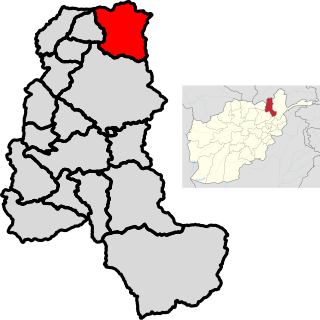
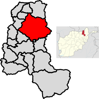
Takhar is one of the thirty-four provinces of Afghanistan, located in the northeast of the country next to Tajikistan. It is surrounded by Badakhshan in the east, Panjshir in the south, and Baghlan and Kunduz in the west. The city of Taloqan serves as its capital.

Maidan Wardak or Maidan, also called Wardag or Wardak, is one of the 34 provinces of Afghanistan, located in the central region of Afghanistan. It is divided into eight districts and has a population of approximately 500,000. The capital of the province is Maidan Shar, while the most populous district in the province is Saydabad District. Wardak is known for one of its famous high peak mountain known as.

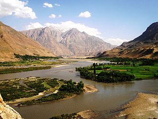
Badakhshan Province is one of the 34 provinces of Afghanistan, located in the northeastern part of the country. It is bordered by Tajikistan's Gorno-Badakhshan in the north and the Pakistani regions of Lower and Upper Chitral and Gilgit-Baltistan in the southeast. It also has a 91-kilometer (57-mile) border with China in the east.
The Northern Alliance, officially known as the United Islamic National Front for the Salvation of Afghanistan, was a military alliance of groups that operated between late 1996 to 2001 after the Islamic Emirate of Afghanistan (Taliban) took over Kabul. The United Front was originally assembled by key leaders of the Islamic State of Afghanistan, particularly president Burhanuddin Rabbani and former Defense Minister Ahmad Shah Massoud. Initially it included mostly Tajiks but by 2000, leaders of other ethnic groups had joined the Northern Alliance. This included Karim Khalili, Abdul Rashid Dostum, Abdullah Abdullah, Mohammad Mohaqiq, Abdul Qadir, Asif Mohseni, Amrullah Saleh and others.
Maidan Shar, also Maidan Shahr or simply Maidan, is the capital of Maidan Wardak province in central Afghanistan. Its population was estimated to be 35,008 in 2003, of which are Pashtuns, Hazaras and Tajiks.
Shighnan, also Shignan, Shugnan, Shughnan, and Khughnan, is an historic region whose name today may also refer to a town and a district in Badakhshan Province in the mountainous northeast of Afghanistan and also a district in Gorno-Badakhshan Autonomous Province in Tajikistan. The administrative center of the Shighnan District of Afghanistan is called Qaleh Barpanjeh. The administrative center of the Shughnon District of Tajikistan is called Khorogh.
Zebak is the capital of the Zebak District in the Badakhshan province of Afghanistan. The city is based in the delta of the Sanglich river.

Khwahan /(Tajik: Хоҳон) is a town and the capital of Khwahan District, in Badakhshan Province in north-eastern Afghanistan. It is located on the left bank of the Panj River, subregions of Darwaz.

Kishim District is one of the 29 districts of Badakhshan province in eastern Afghanistan.The district capital is Mashhad. The district is located in the Keshem Valley, a primarily rural area on the western edge of the province, and is home to approximately 89,833 residents, making it the second most populous district of the province.

Shahri Buzurg also spelled as Shahr-e Bozorg is one of the 28 districts of Badakhshan province in eastern Afghanistan. The capital is the city of Shahr-e Bozorg. Its northwestern border is along the international border between Afghanistan and Tajikistan while its southwestern border is with Takhar province. Located on the western edge of the province, Shahri Buzurg hosts a population of approximately 42,000 residents.

Khwahan District, is one of the 28 districts of Badakhshan province, located in northeastern Afghanistan. The district capital is Khwahan. The district borders Raghistan to the southwest, Kuf Ab in the northeast, the Panj River in the northwest, and Shuro-obod district, Khatlon province of Tajikistan. Kuh-e kallat
Chah Ab District is a district of Takhar Province, Afghanistan. Its district center is Chah Ab. The district's economy is primarily based on agriculture and livestock.
Rustaq District is a district of Takhar Province, northern Afghanistan. The district centre is the town of Rostaq. As recently as 2020, the district was considered to be under government control, as opposed to control by the Taliban. However, the district has had issues with illegal armed men.
Pa'in Shahr is a village in Badakhshan Province in north-eastern Afghanistan.
Qalʽeh-ye Kuf or Qala-e Kuf Persian: قلعه کوف is a village and Capital District Kuf Ab in Badakhshan Province in north-eastern Afghanistan.
Shahr-e Monjan is a village in Badakhshan Province in north-eastern Afghanistan.
Bozorg (بزرگ), or Gozorg meaning Great in Persian, may refer to:

Fayzabad is a city in northeastern Afghanistan, with a population of around 39,555 people. It serves as the provincial capital and largest city of Badakhshan Province. It is situated in Fayzabad District and is at an altitude of 1,254 metres (4,114 ft).

Raghistan is one of the 28 districts of Badakhshan Province in eastern Afghanistan. Located in the northwestern portion of the province, Ragh is home to approximately 44,004 residents. The capital city is Ziraki.
2021 (MMXXI) was a common year starting on Friday of the Gregorian calendar, the 2021st year of the Common Era (CE) and Anno Domini (AD) designations, the 21st year of the 3rd millennium and the 21st century, and the 2nd year of the 2020s decade.
