
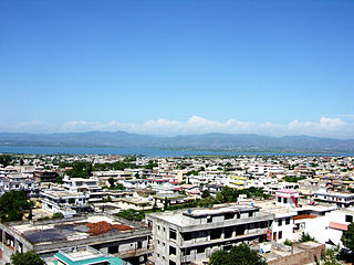
Sukkur is a city in the Pakistani province of Sindh along the western bank of the Indus River, directly across from the historic city of Rohri. Sukkur is the third largest city in Sindh after Karachi and Hyderabad, and 14th largest city of Pakistan by population. New Sukkur was established during the British era alongside the village of Sukkur. Sukkur's hill, along with the hill on the river island of Bukkur, form what is sometimes considered the "Gate of Sindh".
Mirpur, officially known as New Mirpur City, is the capital of Mirpur district located in Azad Kashmir, Pakistan which has been subject of dispute between India and Pakistan since 1947. It is the second largest city of Azad Kashmir and 74th largest city in Pakistan.

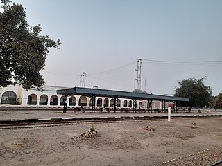
Sheikhupura also known as Qila Sheikhupura, is a city and district in the Pakistani province of Punjab. Founded by the Mughal Emperor Jehangir in 1607, Sheikhupura is the 16th largest city of Pakistan by population and is the headquarters of Sheikhupura District. The city is an industrial centre and satellite town, and is located about 38 km northwest of Lahore. It also borders Sialkot, Gujranwala, Nankana Sahib and Kasur districts of Punjab, Pakistan.

Sahiwal, formerly known as Montgomery, is a city in Punjab, Pakistan. It is the 21st largest city of Pakistan by population and the administrative capital of both Sahiwal District and Sahiwal Division. Sahiwal is approximately 180 km from the major city Lahore and 100 km from Faisalabad and lies between Lahore and Multan. Sahiwal is approximately 152 meters above the sea level.
Chichawatni is a city in the Sahiwal District of the Punjab province of Pakistan. It is the administrative center of Chichawatni Tehsil. Situated near the old main road called Grand Trunk Road, it lies approximately 45 kilometres (28 mi) from the district capital, Sahiwal. In 2011, Chichawatni's population was estimated at 160,000.
Layyah District, is a district in the Punjab, Pakistan. It is located in the southern part of the province. Layyah is the district headquarter of Layyah District. Layyah has hot desert climate.
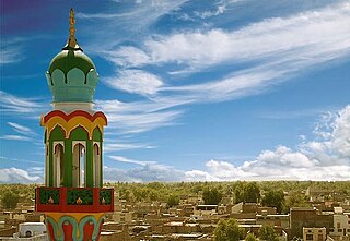
Bahawalnagar District, is a district of Punjab province in Pakistan. Before the independence of Pakistan, Bahawalnagar was part of Bahawalpur state governed by the Nawab of Bahawalpur. The city of Bahawalnagar is the capital of the district.

Okara District, is a district of Punjab, Pakistan. It became a separate district in 1982, prior to that it was part of Sahiwal District.

Burewala, is a city of Vehari District in Punjab, Pakistan. The city of Burewala is the headquarters of Burewala Tehsil, an administrative subdivision of the district. It is the 34th largest city of Pakistan by population.

Safdarabad, is a city in Sheikhupura District in the Punjab province of Pakistan. The city of Safdar Abad is the capital of Safdarabad Tehsil. Its Postal code or ZIP code is 39540. Its urban area is approximately 600 acres. Until 2005 it was a tehsil of Sheikhupura District, but in that year Sheikhpura was bifurcated and the district of Nankana Sahib was created. - with Safdarabad as one of its tehsils. Now at present, once again Safdarabad has been rejoined with Sheikhupura as a Tehsil. The city of Safdarabad lies 95 km from Lahore the provincial capital of Punjab. The area has a population of more than 40,000 the majority of whom are Muslims. There are many engineering and medical students from Safdarabad admitted to different universities across Pakistan, including UET, Lahore.

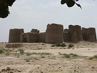
Rajanpur is a district of the Pakistani province of Punjab, with its administrative headquarters the city of Rajanpur. Lying west of the Indus River, its inhabitants are mostly Saraikis and Baloch. According to the 1998 census, the district had a population of 1,100,000, and 14.27% of these were inhabitants of urban areas.
Shahkot is a small city and one of the five tehsils of Jalandhar district in Punjab, India. Shahkot is situated on Jalandhar-Moga-Barnala-Sirsa National Highway 703. Shahkot is administered by the Municipal Committee. About 176 villages belong to Shahkot tehsil. Shahkot was famous for its red chili peppers; but now, its main crops are Wheat, Paddy, Maize, potato, etc. Agricultural land is not suitable for paddy. But with the use of pesticides and tubewell water; paddy is grown.
Qaidabad, is a city and tehsil of Khushab District in the Punjab, Pakistan. It is located 283 kilometers away from Islamabad and 295 kilometers from Lahore in North West Punjab. It is located on main Lahore Mianwali road, 90 kilometers from Sargodha and 40 kilometers from Khushab. It is founded by Sardar Abdul Rab Nishter in 1951 named after Quaid e Azam.

Bhagwal, is a village & Union Council of Kharian Tehsil, Gujrat District,in the Punjab province of Pakistan. Bhagwal distance from Pakistan's capital, Islamabad, is approximately 131 kilometres (81 mi).
Safdarabad, is an administrative subdivision (Tehsil) of Sheikhupura District in the Punjab province of Pakistan. The city of Safdar Abad is the headquarters of the tehsil, until 2005 it was a tehsil of Sheikhupura District, but in that year Sheikhpura was bifurcated and the district of Nankana Sahib was created. - with Safdarabad as one of its tehsils. Now at present, once again Safdarabad has been rejoined with Sheikhupura as a Tehsil. The city of Safdarabad lies 95 km from Lahore the provincial capital of Punjab. The tehsil has a population of more than 270,000 the majority of whom are Muslims.
Khudian Khas, is a large town and Municipal Committee of Kasur District in the Punjab province of Pakistan..Khudian is part of Kasur Tehsil and is at an altitude of 177 meters (583 feet) above sea level. The Sutlej River, which flows on the India-Pakistan border, is 20 kilometers from Khudian. It is 33 kilometers from India-Pakistan border of Ganda Singh Wala.
Gulyana is a town in the Gujar Khan Tehsil of Rawalpindi District, in the Punjab province of Pakistan. Gulyana is also chief town of Union Council Gulyana which is an administrative subdivision of the Tehsil.
Raipur, located in the Sardulgarh tehsil of Mansa district in Punjab, India, is an old and noted village of the area. The famous Babbar martyr Bhai Gurmel Singh from the village was martyred during an operation in Maujia on 8 September 1991.
Dhoul Ranjha is a village and Union council of Phalia Tehsil in Mandi Bahauddin District of Punjab, Pakistan.
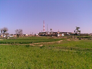
Chahrkey is a village located at Latitude 32°25'8.08 Longitude: 73°50'4.35 in tehsil Phalia, Mandi Bahauddin District, Punjab, Pakistan. This beautiful locality is situated on the bank of Chenab River. Its estimated terrain elevation above sea level is 219 metres. The nearest towns are Jokalian, Khoosar, Narang, Kamonkey, Ratti Pindi and Saad Ullah Pur. On the other bank of Chenab River, Ali Pur Chatta and Rasulnagar are situated. The earlier name of Rasulnagar was Ramnagar. Chahrkey is full of lush green fields. In 1973, the village almost drowned in a flood and then the government built a flood safety wall on its south side to save the population of numerous villages, in future. Qadirabad Headworks is situated 6 km west of Chahrkey on Chenab River. A battle fought on 22 November 1848 in nearby towns of Saad Ullah Pur and Ramnagar between British Army and Khalsa Sikh . Chahrkey is included in the Constituency PP-117. The earlier Name of this constituency was PP-99 and it was changed in 2008 elections.

