Jhargram is a small planned town and a municipality in the Indian state of West Bengal. It is the headquarters of the Jhargram district. It is a popular tourist destination known for its forests, ancient temples and royal palaces.

Safdarabad, is city in Sheikhupura District in the Punjab province of Pakistan. The city of Safdar Abad is the capital of Safdarabad Tehsil. Its Postal code or ZIP code is 39540. Its urban area is approximately 600 acres. Until 2005 it was a tehsil of Sheikhupura District, but in that year Sheikhpura was bifurcated and the district of Nankana Sahib was created. - with Safdarabad as one of its tehsils. Now at present, once again Safdarabad has been rejoined with Sheikhupura as a Tehsil of it. The city of Safdarabad lies 95 km from Lahore the provincial capital of Punjab. The area has a population of more than 40,000 the majority of whom are Muslims. There are many engineering and medical students from Safdarabad admitted to different universities across Pakistan, including UET, Lahore.

Gujranwala District, is a district that is a part of the Majha region in Punjab, Pakistan. Gujranwala District is bordered by the districts of Wazirabad, Sialkot, Hafizabad and Sheikhupura. Gujranwala district has 5 National Assembly and 12 Punjab Assembly constituencies. Gujranwala is known as the city of wrestlers and famous for its food.

Salepur is a town and a Notified Area Council in the Cuttack district of Odisha, India.
Kaikamba also known as Gurupura Kaikamba is a suburban town of Mangalore, Dakshina Kannada District, Karnataka State, west coast of India. Kaikamba lies between Moodabidri and Mangalore city in Dakshina Kannada district. This town lies on Mangalore – Moodabidri Highway National Highway 169. It is 8 km away from Bajpe, where Mangalore International Airport is located. Population of Kaikamba is about 15,325 as per 2009 census. Parts of Kaikamba are administered by Kandavara Panchayat and Ganjimutt Panchayat. Efforts are being made to include this town into Mangalore city corporation limits by the year 2015. The proposed KIADB Software export promotional park is 5 km away.
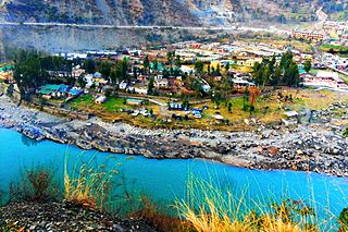
Ramban is a town in Ramban district of Jammu and Kashmir, India, which is the district headquarters of Ramban district. It lies on the banks of the Chenab river in Chenab Valley on the National Highway-1A at about 120 km from Jammu and about 130 km from Srinagar, making it almost the central point on the Jammu-Srinagar National Highway.
Potha Sharif is a village and union council of Murree Tehsil in the Murree District of Punjab, Pakistan. It is located in the north-east of the tehsil at 33°57'0N 73°30'0E, and is bounded to the north by Phagwari, to the south by Sehr Bagla, to the west by Rawat and to the east by Kashmir. The village contains the mazar of the Sufi saint Hazarat Dada Malik Suraj Abbasi, forefather of the Potha Shareef people. He had seven sons and their descendants are currently present in Potha Shareef. People visit the mazar from different areas of the country to offer tribute.
Dheedwal is a town 17 kilometers from Chakwal in Punjab, Pakistan. It has a hospital, a college, a bank, a utility store and some other services like telephone, cable and also water and gas supply.

Sadhoke is a town of Tehsil Kamoke in Gujranwala District in Punjab (Pakistan). It is located on Grand Trunk Road N-5.
Kala Shah Kaku is a town located in Sheikhupura District, Punjab, Pakistan. It is part of the Ferozewala Tehsil of Sheikhupura District. Kala Shah Kaku is on the M-2 motorway and Grand Trunk Road 19 km west from Lahore. It is the main entry point of Lahore from Peshawar, Rawalpindi, Sialkot, Kharian, Gujrat, Jehlum, Wazirabad and Gujranwala via GT Road. It was earlier famous due to Pakistan State Oil (PSO) depot being located here. This depot was the main source of fuel supply to Lahore, Gujranwala, Sheikhupura and Kasur etc

The Special Communications Organization (SCO) (Urdu: خصوصی مواصلاتی تنظیم) is Pakistani public sector organization operated by MoIT&T. SCO plays a role in providing telecommunication services in Azad Kashmir and Gilgit Baltistan to almost 1.7 million people, a quarter of the total population. It operates its digital financial services under the brand name S-Paisa.

Shergarh, is an historic town, union council, and major administrative subdivision of Depalpur Tehsil, Okara District, Punjab, Pakistan.
Nurkot is a town located on the western bank of the Nullah Baein torrent, 30 km by road northeast of Narowal city, and around 5 km southwest of Shakargarh city in Shakargarh Tehsil, Narowal District, Punjab. Situated at an elevation of 258 meters, Nurkot has grown together with the neighbouring town of Maingri, and the two are often collectively referred to as a single entity. Together, they form the largest and the most significant town of the Constituency PP-56 of the Provincial Assembly of Punjab.
Chakloo is a village on the bank of the Jhelum River, in the Baramulla District of Jammu and Kashmir, India. It is 7 km from the Baramulla. There are two bridges which connect the village to Kanispora via Ladoora, and Kawaja Bagh via Jambazpora respectively. Its Block is Nadihal, Constituency Rafiabad, Post Office Rohama, Zone/ Police Station/ Tehsil/ District Baramulla, and Jammu and Kashmir. There are Eight Mohalas in the village namely sadeeque colony, Alnoor colony,Usmaan Abaad, Eidgah colony, Gazi Mohalla,sofi mohalla, Dar Mohalla, and Peer Mohalla. Recently the village was given a new administrative unit (Nayabat).

Bunga Hayat is a small town in Pakpattan District, Sahiwal Division, Punjab, Pakistan, having a population of 10,000. It is named after Mian Hayat Maneka, an ancestor of the Maneka Family. Prominent politicians from the area are Mian Khudayar Khan Maneka, elected twice as the MLA before partition. Mian Farrukh Mumtaz Maneka (MPA) Mian Khurram Mumtaz Maneka (UC Nazim) and Mian Asadullah Mumtaz Maneka(Ex.District Naib Nazim Pakpattan) Mian Muhammad Yar khan Maneka (Member Zilla council 2 times ) and Mian Mimshad Ahmed Maneka (Member zilla council) Their father Mian Mumtaz Maneka was also an influential political leader of the area. Among 28 Union Councils of Tehsil Pakpattan, Bunga Hayat Union Council is UC-03. UC Bunga Hayat Consists of Bunga Hayat, Nanakpur, Asadullah, Arazi Amar Singh, Magan Pur, 5 Marla Scheme & 7 Marla Scheme.
Shair Pur is a village located in Wazirabad Tehsil, Gujranwala District, Punjab, Pakistan.
Amrao Khurd is a small village in the Hafizabad District of Punjab, Pakistan. Word Amrao means noble and Khurd is administrative designations used in India and Pakistan to indicate the smaller segments of a town, village or settlement. It is located at 32°16′01.4″N 73°39′47.3″E with an altitude of 207 meters.
Kondur or Kandoora is the largest village in the Sukhnag River valley, located on the eastern banks of the Sukhnag River. It lies on the Beerwah-to-Doodhpathri road and is 26 kilometres (16 mi) from Srinagar, the largest city and summer capital of the union territory of Jammu and Kashmir, which is the southern portion of the wider Indian-administered Kashmir region.
Badoki Saikhwan or Baddoki Seikhwan is a village in Tehsil Nowshera Virkan, District Gujranwala, Punjab, Pakistan. It has historical remnants of the Mughal Empire and the Sikh Empire. It is located at 32°8' N 74°1' E, west of Gujranwala, the district capital. Its population was estimated to be 2500 in December 2020. It lies near the Gujranwala-Hafizabad road, 35 km west of Gujranwala city.

Patushay, alternatively known as Potshai, stood as an independent village within the scenic Bandipora district of Jammu and Kashmir, India. Its fate intertwined with Qazipora, leading to the emergence of a consolidated community named Qazipora Patushi. Situated at a distance of 4km from the bustling Bandipora town and 59km from the vibrant city of Srinagar, Patushay owes its name to the amalgamation of "Poàt," signifying antiquity, and "Shay," representing a site rich in historical significance.


