Shane Bernagh Donnelly was an Irish rapparee who was active in the Cappagh and Altmore area of County Tyrone during the 17th century who would use the mountains as a vantage point to launch daring hold ups on carriages passing through the area on the main Dublin to Derry road nearby.[1] Local legend has it that the highwayman assisted impoverished locals with his robberies, which primarily targeted members of the Protestant Ascendancy. A barracks was built in the Altmore area in an attempt to curb his activities but to little avail. Because of this Bernagh has over time become a local legend in the mould of Robin Hood who robbed from the rich and gave to the poor.
For example, in the Slieve Beagh mountains of County Monaghan, a large Celtic cross now tops a Mass rock known as Leacht a 'tSagairt ("The Priest's Flagstone"). The cross is said in the local oral tradition to mark where a priest hunter fatally shot a Fr. McKenna while he was saying Mass there on Christmas Day. The priest hunter is said to have been assassinated by Shane Bernagh soon afterwards in nearby Emyvale.[2]
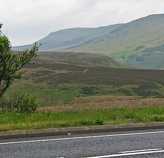
He was eventually captured and executed by the Dublin Castle administration, and his body was cast into a lough at the summit of Slieve Beagh, which straddles the counties of Tyrone, Fermanagh and Monaghan. He was immortalised further by local scholar George Sigerson in his balladThe Mountains of Pomeroy and Irish poet John Montague in his poem A Lost Tradition. There is a small rocky area on the outskirts of Cappagh and Altmore called Shane Bernagh's Chair, called so as it is shaped like a chair. It received its fame from the highwayman, who used the rugged mountain area to hide out and launch his next attack on his unsuspecting victims. Local oral tradition says that the nearby Bernish Glen gave Shane his middle name, Bernagh, after Donnelly jumped across the glen on horse back as he sought to evade Crown soldiers pursuing him.
A verse from Montague's A Lost Tradition states that:
The heathery gap where the Rapparee, Shane Bernagh, saw his brother die. On a summer's day the dying sun stained its colours to crimson. So breaks the heart, Brish mó Cree.
Notes
↑ McCallen, Jim (1993). Stand and Deliver. Stories of Irish Highwaymen. Ireland Mercier Press. ISBN1-85635-036-3.
↑ Tony Nugent (2013), Were You at the Rock? The History of Mass Rocks in Ireland, The Liffey Press. Pages 200-201.
County Armagh is one of the six counties of Northern Ireland and one of the traditional thirty-two counties of Ireland. It is located in the province of Ulster and adjoins the southern shore of Lough Neagh. It borders the Northern Irish counties of Tyrone to the west and Down to the east. The county borders Louth and Monaghan to the south and southwest, which are in the Republic of Ireland. It is named after its county town, Armagh, which derives from the Irish Ard Mhacha, meaning "Macha's height". Macha was a sovereignty goddess in Irish mythology and is said to have been buried on a wooded hill around which the town of Armagh grew. County Armagh is colloquially known as the "Orchard County" because of its many apple orchards.
In Gaelic myth, the Cailleach is a divine hag and ancestor, associated with the creation of the landscape and with the weather, especially storms and winter. The word literally means 'old woman, hag', and is found with this meaning in modern Irish and Scottish Gaelic, and has been applied to numerous mythological and folkloric figures in Ireland, Scotland, and the Isle of Man. In modern Irish folklore studies, she is sometimes known as The Hag of Beara, while in Scotland she is known as Beira, Queen of Winter.
William Carleton was an Irish writer and novelist. He is best known for his Traits and Stories of the Irish Peasantry, a collection of ethnic sketches of the stereotypical Irishman.
County Monaghan is a county in Ireland. It is in the province of Ulster and is part of Border strategic planning area of the Northern and Western Region. It is named after the town of Monaghan. Monaghan County Council is the local authority for the county. The population of the county was 65,288 according to the 2022 census.
The Glenshane Pass is a major mountain pass cutting through the Sperrin Mountains in County Londonderry, Northern Ireland. It is in the townland of Glenshane Pass on the main Derry to Belfast route, the A6.
Carrickmore is a small town in County Tyrone, Northern Ireland. It is situated in the historic barony of Omagh East, the civil parish of Termonmaguirk and the Roman Catholic Parish of Termonmaguirc between Cookstown, Dungannon and Omagh. It had a population of 612 in the 2001 Census. In the 2011 Census 2,330 people lived in the Termon Ward, which covers the Carrickmore and Creggan areas.
Pomeroy is a small village and civil parish in County Tyrone, Northern Ireland. It is in the townland of Cavanakeeran, about 8.5 miles (14 km) from Cookstown, 9 miles (14 km) from Dungannon and 16 miles (26 km) from Omagh. The 2011 Census recorded a population of 788 people.
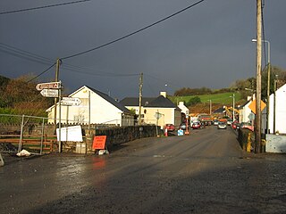
Cappagh is a small village and townland in the parish of Pomeroy in County Tyrone, Northern Ireland. Around 10 kilometres (6 mi) north-west of Dungannon, it is between Pomeroy, Ballygawley, Galbally and Carrickmore, with the hamlet of Galbally about one mile to the east. Most of the land around Cappagh is farmland although a quarry lies just outside the village. In County Tyrone, there is also the parish of Cappagh which includes part of the town of Omagh and small village of Mountfield.
Altmore ) is a hamlet and townland in County Tyrone, Northern Ireland. It is five miles from Carrickmore and four miles from Pomeroy. The townland is actually called Altmore and is situated in the historic barony of Dungannon Middle and the civil parish of Pomeroy and covers an area of 1117 acres.
Scotstown is a village in the townland of Bough in north County Monaghan, Ireland. Scotstown is located in the parish of Tydavnet, along the Monaghan Blackwater, Scotstown being the village closest to the river's source. Scotstown is centred in the townland of Bough, but extends into Carrowhatta, Teraverty, Drumdesco and Stracrunnion townlands.
Count Redmond O'Hanlon, was a 17th-century Irish tóraidhe or rapparee; an outlawed member of the Gaelic nobility of Ireland who still held to the code of conduct of the traditional chiefs of the Irish clans.
Slieve Gullion is a mountain in the south of County Armagh, Northern Ireland. The mountain is the heart of the Ring of Gullion and is the highest point in the county, with an elevation of 573 metres (1,880 ft). At the summit is a small lake and two ancient burial cairns, one of which is the highest surviving passage grave in Ireland. Slieve Gullion appears in Irish mythology, where it is associated with the Cailleach and the heroes Fionn mac Cumhaill and Cú Chulainn. It dominates the countryside around it, offering views as far away as Antrim, Dublin Bay and Wicklow on a clear day. Slieve Gullion Forest Park is on its eastern slope.
Hollyford is a small village in County Tipperary, Ireland. It is in the Roman Catholic parish of Kilcommon and Hollyford and Rearcross, in the Archdiocese of Cashel and Emly, and is in the barony of Kilnamanagh Lower.
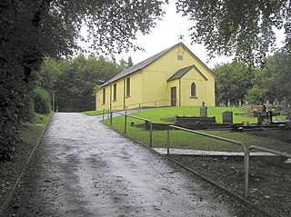
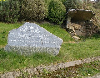
A Mass rock was a rock used as an altar by the Catholic Church in Ireland, during the 17th and 18th centuries, as a location for secret and illegal gatherings of faithful attending the Mass offered by outlawed priests. Similar altars, known as Mass stones, were used by the similarly illegal and underground Catholic Church in Scotland, membership in which was similarly criminalised following the Scottish Reformation in the mid-16th century.
A priest hunter was a person who, acting on behalf of the English and later British government, spied on or captured Catholic priests during Penal Times. Priest hunters were effectively bounty hunters. Some were volunteers, experienced soldiers or former spies.
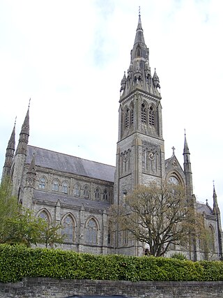
The Diocese of Clogher is a Latin Church diocese of the Catholic Church in Ireland. It was formed in 1111 at the Synod of Rathbreasail as the see for the Kingdom of Uí Chremthainn. It is part of the Province of Armagh.
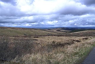
Slieve Beagh is a mountainous area straddling the border between County Monaghan in the Republic of Ireland and County Fermanagh and County Tyrone in Northern Ireland. A point just east of its summit is the highest point in Monaghan; however the true summit is on the Fermanagh-Tyrone border. The point where the three counties meet, is referred to as the "Three County Hollow".
Éamonn Ó Ciardha is an Irish historian and writer.
The 1991 Cappagh killings was a gun attack by the loyalist Ulster Volunteer Force (UVF) on 3 March 1991 in the village of Cappagh, County Tyrone, Northern Ireland. A unit of the UVF's Mid-Ulster Brigade drove to the staunchly republican village and shot dead three Provisional IRA members and a Catholic civilian at Boyle's Bar.
Killykeskeame is a townland in the Civil Parish of Killeevan, in the Barony of Dartree, County Monaghan. It consists of 126.49 acres. The name Killykeskeame is an anglicisation of the Gaelic "Cill Choiscéim" which means the 'Church of the Footstep', referencing a medieval chapel that once was located in the townland.
This page is based on this Wikipedia article Text is available under the CC BY-SA 4.0 license; additional terms may apply. Images, videos and audio are available under their respective licenses.