
The Farne Islands are a group of islands off the coast of Northumberland, England. The group has between 15 and 20 islands depending on the level of the tide. They form an archipelago, divided into the Inner Group and the Outer Group. The main islands in the Inner Group are Inner Farne, Knoxes Reef, the East and West Wideopens, and the Megstone; the main islands in the Outer Group are Staple Island, Brownsman, North and South Wamses, Big Harcar, and Longstone. The two groups are separated by Staple Sound. The highest point, on Inner Farne, is 62 feet (19 m) above mean sea level.
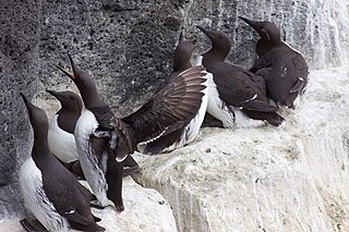
Guillemot is the common name for several species of seabird in the Alcidae or auk family. In British use, the term comprises two genera: Uria and Cepphus. In North America the Uria species are called murres and only the Cepphus species are called "guillemots". This word of French origin derives from a form of the name William, cf. French: Guillaume.

The pigeon guillemot is a species of bird in the auk family, Alcidae. One of three species in the genus Cepphus, it is most closely related to the spectacled guillemot. There are five subspecies of the pigeon guillemot; all subspecies, when in breeding plumage, are dark brown with a black iridescent sheen and a distinctive wing patch broken by a brown-black wedge. Its non-breeding plumage has mottled grey and black upperparts and white underparts. The long bill is black, as are the claws. The legs, feet, and inside of the mouth are red. It closely resembles the black guillemot, which is slightly smaller and lacks the dark wing wedge present in the pigeon guillemot.
Handa Island or simply Handa is an island off the west coast of Sutherland, Scotland. It is 309 hectares and 123 metres (404 ft) at its highest point.
Clear Island or Cape Clear Island is an island off the south-west coast of County Cork in Ireland. It is the southernmost inhabited part of Ireland and has a population of 147 people. It is an official Gaeltacht area, and most inhabitants speak Irish and English. Its nearest neighbouring island is Sherkin Island, which is 2 kilometres east of the Cape Clear Island. The island is divided into east and west halves by an isthmus called the Waist, with the North Harbour to the landward side and the South Harbour on the seaward side. Ferries sail regularly from the North Harbour to Schull and Baltimore on the mainland. The South Harbour is a popular berth for yachts and pleasure boats.
Bonaventure Island is a Canadian island in the Gulf of St. Lawrence located 3.5 km (2.2 mi) off the southern coast of Quebec's Gaspé Peninsula, 5 km (3.1 mi) southeast of the village of Percé. Roughly circular in shape, it has an area measuring 4.16 km2 (1.61 sq mi).

South Stack is an island situated just off Holy Island on the northwest coast of Anglesey, Wales.

The Saltee Islands are a pair of small islands lying 5 kilometres off the southern coast of County Wexford in Ireland. The two islands are Great Saltee and Little Saltee. They have been largely unoccupied since the early 20th century and have been privately owned by the Neale family since 1943. Together the islands cover an area of 1.2 square kilometers.
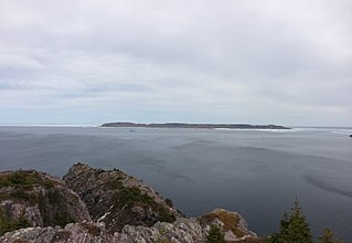
Baccalieu Island or Bacalhoo Island is a 5 km2 uninhabited island at the northern extremities of Conception Bay in Subdivision 1G, near the community of Red Head Cove, Newfoundland and Labrador, Canada. It is separated from the island of Newfoundland by Baccalieu Tickle, a small strait and an abundant fishing ground. The island has some trees but is mostly rocky.

Puffin Island is an uninhabited island off the eastern tip of Anglesey, Wales. It was formerly known as Priestholm in English and Ynys Lannog in Welsh. A hermitage was established here around the 6th century, and there are remains of a 12th-century monastery on the island. The island is also a Special Protection Area for wildlife.

The Arctic Cordillera is a terrestrial ecozone in northern Canada characterized by a vast, deeply dissected chain of mountain ranges extending along the northeastern flank of the Canadian Arctic Archipelago from Ellesmere Island to the northeasternmost part of the Labrador Peninsula in northern Labrador and northern Quebec, Canada. It spans most of the eastern coast of Nunavut with high glaciated peaks rising through ice fields and some of Canada's largest ice caps, including the Penny Ice Cap on Baffin Island. It is bounded to the east by Baffin Bay, Davis Strait and the Labrador Sea while its northern portion is bounded by the Arctic Ocean.

The Shantar Islands are a group of fifteen islands located off the northwestern shore of the Sea of Okhotsk east of Uda Gulf and north of Academy Bay. Most of the islands have rugged cliffs, but they are of moderate height; the highest point in the island group is 720 metres. The name of the island group has its origins in the Nivkh language from the word ч’андь č’and’ meaning "to be white". The islands are currently uninhabited.
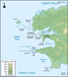
Iroise or the Iroise Sea is the part of the Atlantic Ocean which stretches from the Ile de Sein to Ushant off the coast of Brittany in north-western France. It is contained within the Celtic Sea, bordering the remainder of the Celtic Sea to the north and west, and the Bay of Biscay to the south. It is one of the most dangerous seas in Europe for sea-going vessels. In winter, there are often violent storms with huge waves. It is also one of the richest areas for marine life and was designated as one of UNESCO's biosphere reserves in 1988 and as France's first marine park in October 2007.
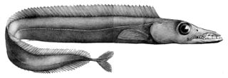
The black scabbardfish is a bathypelagic cutlassfish of the family Trichiuridae found in the Atlantic Ocean between latitudes 69°N and 27°N at depths between 180 and 1,700 m. Its length is up to 110 cm (3.6 ft), but it reaches maturity around 80 to 85 cm.
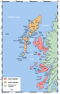
The flora and fauna of the Outer Hebrides in north west Scotland comprises a unique and diverse ecosystem. A long archipelago, set on the eastern shores of the Atlantic Ocean, it attracts a wide variety of seabirds, and thanks to the Gulf Stream a climate more mild than might be expected at this latitude. Because it is on the Gulf Stream, it also occasionally gets exotic visitors.

The Skerries are a small group of rocky islands (skerries) just off Portrush, County Antrim, on the north coast of Northern Ireland. Winkle Isle is the local name for the large Skerry island, the small Skerry being known as Castle Isle. The islands are part of an Area of Special Scientific Interest.

The Irish Sea is an extensive body of water that separates the islands of Ireland and Great Britain. It is linked to the Celtic Sea in the south by St George's Channel and to the Inner Seas off the West Coast of Scotland in the north by the North Channel.

Bodega Head State Marine Reserve (SMR) and Bodega Head State Marine Conservation Area (SMCA) are two adjoining marine protected areas off Bodega Bay in Sonoma County on California’s north-central coast. The combined area of these marine protected areas is 21.64 square miles (56.0 km2), with 9.3 square miles (24 km2) in the SMR, and 12.34square miles in the SMCA. Bodega Head SMR prohibits the take of all living marine resources. Bodega Head SMCA prohibits the take of all living marine resources, except the recreational and commercial take of pelagic finfish with troll fishing gear or seine, Dungeness crab by trap, and market squid by hand-held dip net and round haul net.

Ragged Island is a privately owned island in Harpswell, Maine, in Cumberland County, Maine, which is geographically within Casco Bay in the Gulf of Maine. It is located at 43°43′39″N69°56′13″W.
