
Volcanism, vulcanism or volcanicity is the phenomenon of eruption of molten rock (magma) onto the surface of the Earth or a solid-surface planet or moon, where lava, pyroclastics, and volcanic gases erupt through a break in the surface called a vent. It includes all phenomena resulting from and causing magma within the crust or mantle of the body, to rise through the crust and form volcanic rocks on the surface. Magmas that reach the surface and solidify form extrusive landforms.

A magma chamber is a large pool of liquid rock beneath the surface of the Earth. The molten rock, or magma, in such a chamber is less dense than the surrounding country rock, which produces buoyant forces on the magma that tend to drive it upwards. If the magma finds a path to the surface, then the result will be a volcanic eruption; consequently, many volcanoes are situated over magma chambers. These chambers are hard to detect deep within the Earth, and therefore most of those known are close to the surface, commonly between 1 km and 10 km down.
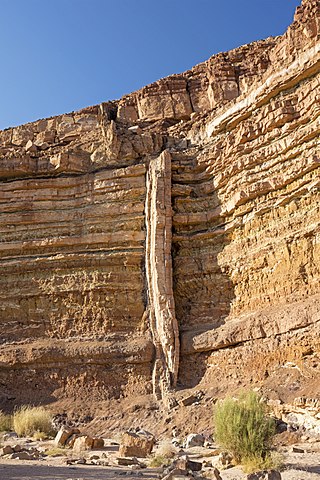
In geology, a dike or dyke is a sheet of rock that is formed in a fracture of a pre-existing rock body. Dikes can be either magmatic or sedimentary in origin. Magmatic dikes form when magma flows into a crack then solidifies as a sheet intrusion, either cutting across layers of rock or through a contiguous mass of rock. Clastic dikes are formed when sediment fills a pre-existing crack.
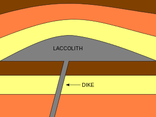
A laccolith is a body of intrusive rock with a dome-shaped upper surface and a level base, fed by a conduit from below. A laccolith forms when magma rising through the Earth's crust begins to spread out horizontally, prying apart the host rock strata. The pressure of the magma is high enough that the overlying strata are forced upward, giving the laccolith its dome-like form.

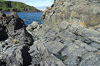
In geology, a sill is a tabular sheet intrusion that has intruded between older layers of sedimentary rock, beds of volcanic lava or tuff, or along the direction of foliation in metamorphic rock. A sill is a concordant intrusive sheet, meaning that a sill does not cut across preexisting rock beds. Stacking of sills builds a sill complex and a large magma chamber at high magma flux. In contrast, a dike is a discordant intrusive sheet, which does cut across older rocks. Sills are fed by dikes, except in unusual locations where they form in nearly vertical beds attached directly to a magma source. The rocks must be brittle and fracture to create the planes along which the magma intrudes the parent rock bodies, whether this occurs along preexisting planes between sedimentary or volcanic beds or weakened planes related to foliation in metamorphic rock. These planes or weakened areas allow the intrusion of a thin sheet-like body of magma paralleling the existing bedding planes, concordant fracture zone, or foliations.

Intrusive rock is formed when magma penetrates existing rock, crystallizes, and solidifies underground to form intrusions, such as batholiths, dikes, sills, laccoliths, and volcanic necks.

A layered intrusion is a large sill-like body of igneous rock which exhibits vertical layering or differences in composition and texture. These intrusions can be many kilometres in area covering from around 100 km2 (39 sq mi) to over 50,000 km2 (19,000 sq mi) and several hundred metres to over one kilometre (3,300 ft) in thickness. While most layered intrusions are Archean to Proterozoic in age, they may be any age such as the Cenozoic Skaergaard intrusion of east Greenland or the Rum layered intrusion in Scotland. Although most are ultramafic to mafic in composition, the Ilimaussaq intrusive complex of Greenland is an alkalic intrusion.
In geology, country rock is the rock native to an area, in contrast to any intrusion of viscous geologic material, commonly magma, or perhaps rock salt or unconsolidated sediments.

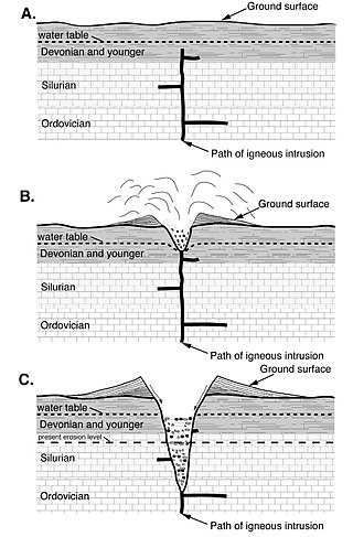
In geology, an igneous intrusion is a body of intrusive igneous rock that forms by crystallization of magma slowly cooling below the surface of the Earth. Intrusions have a wide variety of forms and compositions, illustrated by examples like the Palisades Sill of New York and New Jersey; the Henry Mountains of Utah; the Bushveld Igneous Complex of South Africa; Shiprock in New Mexico; the Ardnamurchan intrusion in Scotland; and the Sierra Nevada Batholith of California.

The Palisades Sill is a Triassic, 200 Ma diabase intrusion. It extends through portions of New York and New Jersey. It is most noteworthy for The Palisades, the cliffs that rise steeply above the western bank of the Hudson River. The ideal location and accessibility of the sill, as well as its unique features, have generated much attention from nature enthusiasts, rock climbers, and geologists alike.
A sheeted dyke complex, or sheeted dike complex, is a series of sub-parallel intrusions of igneous rock, forming a layer within the oceanic crust. At mid-ocean ridges, dykes are formed when magma beneath areas of tectonic plate divergence travels through a fracture in the earlier formed oceanic crust, feeding the lavas above and cooling below the seafloor forming upright columns of igneous rock. Magma continues to cool, as the existing seafloor moves away from the area of divergence, and additional magma is intruded and cools. In some tectonic settings slices of the oceanic crust are obducted (emplaced) upon continental crust, forming an ophiolite.

A ring dike or ring dyke is an intrusive igneous body that is circular, oval or arcuate in plan and has steep contacts. While the widths of ring dikes differ, they can be up to several thousand meters. The most commonly accepted method of ring dike formation is directly related to collapse calderas.
In geology, a chonolith is a type of igneous rock intrusion. Igneous rock intrusions are bodies of igneous rock that are formed by the crystallization of cooled magma below the Earth’s surface. These formations are termed intrusive rocks due the magma intruding rock layers but never reaching the earth’s surface. However, sometimes portions of plutons can become exposed at the Earth’s surface and thus the minerals can be observed since they are large enough. The different plutonic formations are named based on the different shapes that the cooled crystallized magma takes. However, all plutonic formations that have irregular shapes and do not share the same characteristics as other plutonic structures are termed chonoliths. Other plutonic structures that have specific shapes include: dikes, sills, laccoliths and sheets. Another unique characteristic of chonoliths is that there is a floor or base present which is typically absent in other types of intrusions.

The volcanism of Eastern Canada includes the hundreds of volcanic areas and extensive lava formations in Eastern Canada. The region's different volcano and lava types originate from different tectonic settings and types of volcanic eruptions, ranging from passive lava eruptions to violent explosive eruptions. Eastern Canada has very large volumes of magmatic rock called large igneous provinces. They are represented by deep-level plumbing systems consisting of giant dike swarms, sill provinces and layered intrusions. The most capable large igneous provinces in Eastern Canada are Archean age greenstone belts containing a rare volcanic rock called komatiite.

Volcanism of Northern Canada has produced hundreds of volcanic areas and extensive lava formations across Northern Canada. The region's different volcano and lava types originate from different tectonic settings and types of volcanic eruptions, ranging from passive lava eruptions to violent explosive eruptions. Northern Canada has a record of very large volumes of magmatic rock called large igneous provinces. They are represented by deep-level plumbing systems consisting of giant dike swarms, sill provinces and layered intrusions.
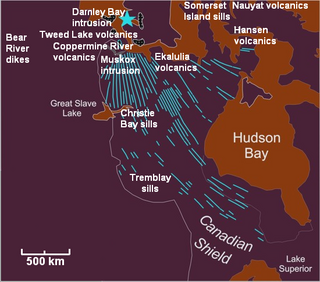
The Mackenzie Large Igneous Province (MLIP) is a major Mesoproterozoic large igneous province of the southwestern, western and northwestern Canadian Shield in Canada. It consists of a group of related igneous rocks that were formed during a massive igneous event starting about 1,270 million years ago. The large igneous province extends from the Arctic in Nunavut to near the Great Lakes in Northwestern Ontario where it meets with the smaller Matachewan dike swarm. Included in the Mackenzie Large Igneous Province are the large Muskox layered intrusion, the Coppermine River flood basalt sequence and the massive northwesterly trending Mackenzie dike swarm.
The methods of pluton emplacement are the ways magma is accommodated in a host rock where the final result is a pluton. The methods of pluton emplacement are not yet fully understood, but there are many different proposed pluton emplacement mechanisms. Stoping, diapirism and ballooning are the widely accepted mechanisms. There is now evidence of incremental emplacement of plutons.

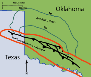
The Southern Oklahoma Aulacogen(ah-lah-coh-jin) (help·info) is a failed rift, or failed rift arm (aulacogen), of the triple junction that became the Iapetus Ocean spreading ridges. It is a significant geological feature in the Western and Southern United States. It formed sometime in the early to mid Cambrian Period and spans the Wichita Mountains, Taovayan Valley, Anadarko Basin, and Hardeman Basin in Southwestern Oklahoma. The Southern Oklahoma Aulacogen is primarily composed of basaltic dikes, gabbros, and units of granitic rock.
The Roosevelt Gabbros are an intrusive igneous geological formation in southwestern Oklahoma. They are one of two formations recognized in the Raggedy Mountain Gabbro Group, the other being the Glen Mountain Layered Complex. The Roosevelt Gabbros are generally characterized as biotite gabbros, which form many dikes and sills through the older Glen Mountain Layered Complex. They are named after the town of Roosevelt in Kiowa County, Oklahoma.

Volcanic and igneous plumbing systems (VIPS) consist of interconnected magma channels and chambers through which magma flows and is stored within Earth's crust. Volcanic plumbing systems can be found in all active tectonic settings, such as mid-oceanic ridges, subduction zones, and mantle plumes, when magmas generated in continental lithosphere, oceanic lithosphere, and in the sub-lithospheric mantle are transported. Magma is first generated by partial melting, followed by segregation and extraction from the source rock to separate the melt from the solid. As magma propagates upwards, a self-organised network of magma channels develops, transporting the melt from lower crust to upper regions. Channelled ascent mechanisms include the formation of dykes and ductile fractures that transport the melt in conduits. For bulk transportation, diapirs carry a large volume of melt and ascent through the crust. When magma stops ascending, or when magma supply stops, magma emplacement occurs. Different mechanisms of emplacement result in different structures, including plutons, sills, laccoliths and lopoliths.
