
Austerlitz is a town in Columbia County, New York, United States. The population was 1,625 at the 2020 census. The town was named after the Battle of Austerlitz.

Copake is a town in Columbia County, New York, United States. The population was 3,346 at the 2020 US census, down from 3,615 at the 2010 census. The town derives its name from a lake, which was known to the natives as Cook-pake, or Ack-kook-peek, meaning "Snake Pond".
Country Knolls is a census-designated place (CDP) in Saratoga County, New York, United States. The population was 5,349 at the 2020 census.

Malta is a town in Saratoga County, New York, United States. The town is in the central part of the county and is south of Saratoga Springs. The population was 17,130 as of the 2020 census.

Henderson Township is a township which is located in Huntingdon County, Pennsylvania, United States. The population was 923 at the time of the 2020 census.

Elk Township is a township in Warren County, Pennsylvania, United States. The population was 468 at the 2020 census, down from 520 at the 2010 census. 551 at the 2000 census.

Alum Creek is a census-designated place (CDP) in Kanawha and Lincoln counties along the Coal River in the U.S. state of West Virginia. It includes the unincorporated communities of Alum Creek, Forks of Coal, and Priestley. The CDP had a population of 1,749 at the 2010 census, down from 1,839 at the 2000 census.

The Town of Waldwick is a town located in Iowa County, Wisconsin, United States. The population was 500 at the 2000 census. The unincorporated communitu of Jonesdale is located in the town.

Indian Springs State Park is a 528-acre (2.14 km2) Georgia state park located near Jackson and Flovilla. The park is named for its several springs, which the Creek Indians used for centuries to heal the sick. The water from these springs is said to have a sulfur smell and taste. Indian Springs is thought to be the oldest state park in the nation. It was acquired from the Creek Indians by the state through the Treaty of Indian Springs (1825) and the Treaty of Washington (1826). Thereafter, Indian Springs has been operated continuously by the state as a public park, although it did not gain the title "State Park" until 1931. The area became a resort town in the 19th century. It became an official "State Forest Park" in 1927. In 1931, along with Vogel State Park, it became a founding unit of Georgia's state park system.
The Nottawaseppi Huron Band of Potawatomi (NHBP) is a federally-recognized tribe of Potawatomi in the United States. The tribe achieved federal recognition on December 19, 1995, and currently has approximately 1500 members.

Philmont is a village in Columbia County, New York, United States. The population was 1,377 at the 2020 census. The village is located in the northeastern part of the town of Claverack on New York State Route 217.

Mill Creek Park is an urban park in Youngstown and Boardman, Ohio. It stretches from the near west side of Youngstown through unincorporated Boardman Township. The park encompasses 2,658 acres (1,076 ha), including three lakes and 45 miles (72 km) of recreational trails. The Trust for Public Land ranks one part of Mill Creek as the 142nd largest park located within the limits of a US city.
A roundabout interchange is a type of interchange between a controlled access highway, such as a motorway or freeway, and a minor road. The slip roads to and from the motorway carriageways converge at a single roundabout, which is grade-separated from the motorway lanes with bridges.

Areas of Critical Environmental Concern (ACEC) is a conservation ecology program in the Western United States, managed by the Bureau of Land Management (BLM). The ACEC program was conceived in the 1976 Federal Lands Policy and Management Act (FLPMA), which established the first conservation ecology mandate for the BLM. The FLPMA mandate directs the BLM to protect important riparian corridors, threatened and endangered species habitats, cultural and archeological resources, as well as unique scenic landscapes that the agency assesses as in need of special management attention.
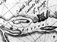
Castle Island is a former island located in the city of Albany, Albany County, New York. Over the past 400 years, Castle Island has been referred to as Martin Gerritse's Island, Patroon's Island, Van Rensselaer Island, and—since the late 19th century—Westerlo Island. The land known as Castle Island has been connected to the mainland and now forms a part of the Port of Albany.

The Luther Forest Technology Campus or LFTC is a 1,414-acre site in the towns of Malta and Stillwater, New York, specifically designed for semiconductor and nanotechnology manufacturing and other innovative technologies. The site has Interstate highway access 1.5 miles (2.4 km) away.

Jackson Creek is an 11.0-mile-long (17.7 km) tributary of Sprout Creek in Dutchess County, New York. Via Sprout Creek and Fishkill Creek, water from Jackson Creek flows to the Hudson River. Jackson Creek's subwatershed covers 5,524 acres (22.35 km2) of land.

The Poesten Kill is a 26.2-mile-long (42.2 km) creek in Rensselaer County, Upstate New York. It flows westerly from its source at Dyken Pond, located in the town of Berlin, to its mouth at the Hudson River in the city of Troy. The creek was historically used as a source of water for the local farmers and residents. During the Industrial Revolution, the creek became an important source of water power, and many mills and factories sprung up along its banks.

The Vischer Ferry Nature and Historic Preserve is a 740-acre (3.0 km2) site along the Mohawk River in the Town of Clifton Park, New York, near the hamlet of Vischer Ferry. It is owned by the New York State Canal Corporation, but Clifton Park maintains its extensive trail system under a special lease arrangement. The preserve also is known as Vischer Ferry Bird Conservation Area.
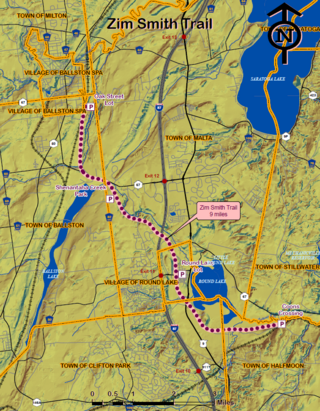
The Zim Smith Trail is the main multi-use trail of a network of trails in Saratoga County, New York. Extending twelve miles, it connects the cities and towns of Mechanicville, Halfmoon, Clifton Park, Round Lake Village, Malta and Ballston Spa. The trail is the route of the former Delaware & Hudson Railroad, originally the Rensselaer & Saratoga Railroad which was completed in 1836. It is the only trail in New York state to be designated a national recreation trail by the U.S. Department of Interior and National Park Service.
