
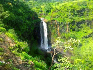
Vidarbha is a geographical region in the east of the Indian state of Maharashtra and a proposed state of central India, comprising the state's Amravati and Nagpur divisions. Amravati Division's former name is Berar. It occupies 31.6% of the total area and holds 21.3% of the total population of Maharashtra. It borders the state of Madhya Pradesh to the north, Chhattisgarh to the east, Telangana to the south and Marathwada and Uttar Maharashtra regions of Maharashtra to the west. Situated in central India. The largest city in Vidarbha is Nagpur followed by Amravati, Akola, and Chandrapur. A majority of Vidarbhians speak Varhadi and Zadi dialects of Marathi.
Amravati district is a district of Maharashtra state in central India. It is the administrative headquarter of Amravati division, which is one of the two divisions in Vidarbha, out of total 6 regions in state of Maharashtra.

Yavatmal (pronunciation is a city and municipal council in the Indian state of Maharashtra. It is the administrative headquarters of Yavatmal District. Yavatmal is around 90 km away from divisional headquarters Amravati while it is 670 km away from the state capital Mumbai. The name is derived from the Marathi Yavat and mal. Another theory is it might be derived from Yavateshwar and Mal as the city is located on a plateau, which is comparatively higher altitude than its other tehsils.
Chikhaldara is a hill station and a municipal council in Amravati district in the Indian state of Maharashtra.
Anjangaon is a city and a municipal council in Amravati district in the state of Maharashtra, India. Anjangaon City got the status of Municipal Council in 1930. It is the first municipal council established in Amravati district and the second biggest council as well. Anjangaon Surji Tehsil was established in 1981. It is technically made up of two main zones, Anjangaon and Surji, on either side of Shahanur River, and is called Anjangaon-Surji in combination. It is called a "Banana Hub of Vidarbha" as it is a large producer of bananas and a hub of medicinal plants - Piper longum and Safed musali.
Chandur bazar is a City governed by a Municipal Council in Amravati district in the state of Maharashtra, India.
Dhamangaon is a city and a municipal council in Amravati district in the state of Maharashtra, India. Dhamangaon is one of the three talukas in Chandur (Railway) subdivision in Amravati district. The municipal council is named as Dattapur-Dhamangaon Municipal council.

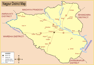
Kalameshwar-Bramhani is a city and a municipal council also a major Industrial hub in Nagpur district in the Indian state of Maharashtra. It is connected to National Highways NH-353I, NH-353J & NH-547E.
Morshi is the second largest town in the Amravati district of Maharashtra, India. It is located 55 km north-east of Amravati, situated very close to the border with Madhya Pradesh, in the scenic southern foothills of the Satpura ranges. Morshi and the surrounding region is also known for the cultivation of Nagpur oranges and the prominent Nal Damayanti Dam.
Multai is a town and a Nagar Palika in Betul district in the Indian state of Madhya Pradesh. Multai is one of the southern cities of Madhya Pradesh, occupying almost half of the Satpura plateau. Considering the small villages around, it occupies a large area in width of the Satpura range between the valley of the Narmada on the north and the barer plains on the south. Forests lie to the west of the city between the districts of East Nimar and Amaraoti. It lies on the Northern bank of the Tapti and the place is also known for being the origin of the Tapti river.
Narkhed is a town and a municipal council in Nagpur district in the Indian state of Maharashtra. It is about 87 km north-west of Nagpur. It is the administrative headquarters of Narkhed taluka, one of the 14 talukas of this district. It is located in the "orange belt" and is a major center for orange-trading.
Pandharkawda is a City and a Municipal council in Yavatmal district in the Indian state of Maharashtra. The Pandharkawada municipality won "Best Municipality at Amravati Division" in 2006 and a quality of education award in 2011. It is near the Saikheda Dam, an earthfill dam on the Khuni River..

Sausar (Saunsar) is a city and a Municipal Council in the central India in the state of Madhya Pradesh. Sausar lies in Vidharbha region, Nagpur is the center for all the economic activities in this region which is just 72 kms from Sausar. More than 90 per cent of farmers produce oranges. Cotton is grown in large quantities in the local area.
Warud is also known as Orange City and a municipal council in Amravati district in the Indian state of Maharashtra
Bhiwapur is a town and a tehsil in Umred subdivision of Nagpur district in Nagpur revenue Division in the Berar region in the state of Maharashtra, India. Bhiwapur city had a gram panchayat and 2015 it became a Nagar Panchayat. Mr Lav Parmanand Janbandhu (INC) became the first President of Bhiwapur Nagar Panchayat and Mr Shankar Rajeram Dadmal becames first Vice President of Bhiwapur Nagar Panchayat and one of the Corporator Mr Balaji Shankar Dewalkar was winning Election by one side voting. He won the election by lot of difference.
Ralegaon is Tehsil place town in Yavatmal District of Maharashtra (India). It is located in Vidarbha region of Maharashra. Geographically it is located northwest from Yavatmal. It is located 42 km away from Yavatmal and 21 km away from the Kalamb which is on Nagpur-Yavatmal road. And just 41 km from city Wardha.
Kondhali is a village in Nagpur District, Nagpur Division, Maharashtra, India, about halfway between Talegaon and Nagpur on NH-6. It is 42 km from Nagpur, 17 km from Katol.

The Narkhed–Badnera line, officially known as the Narkhed–Amravati line, is a single electric branch line which connects Narkhed in Nagpur district to Badnera near Amravati by Indian Railways in the state of Maharashtra. The line is under the administrative jurisdiction of the Central Railway.
Narkhed taluka is one of the 14 taluka of Nagpur district in state of Maharashtra, India.
Jalalkhera is a village in Nagpur district of Maharashtra, India. It connected with National Highway NH-353J. Also it is on the confluence of the Wardha and Jam rivers. It is situated 78 km from Nagpur, and the nearest railway stations are Mowad, Warud, Katol, Narkhed. The town is a tourist attraction as it has the Someshwar Fort Temple as well as the confluence of the two rivers. It is under Ramtek Loksabha Constituency and Katol Vidhan Sabha Constituency.
