
The Bay of Fundy is a bay between the Canadian provinces of New Brunswick and Nova Scotia, with a small portion touching the U.S. state of Maine. It is an arm of the Gulf of Maine. Its tidal range is the highest in the world. The name is probably a corruption of the French word fendu, meaning 'split'.
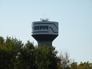
Dieppe is a city in the Canadian maritime province of New Brunswick. Statistics Canada counted the population at 28,114 in 2021, making it the fourth-largest city in the province. On 1 January 2023, Dieppe annexed parts of two neighbouring local service districts; revised census figures have not been released.

The Expulsion of the Acadians was the forced removal of inhabitants of the North American region historically known as Acadia between 1755 and 1764 by Great Britain. It included the modern Canadian Maritime provinces of Nova Scotia, New Brunswick, and Prince Edward Island, along with part of the US state of Maine. The Expulsion occurred during the French and Indian War, the North American theatre of the Seven Years' War.

Shediac is a heavily Acadian town in Westmorland County, New Brunswick. The town is home to the famous Parlee Beach and is known as the "Lobster Capital of the World". It hosts an annual festival every July which promotes its ties to lobster fishing. At the western entrance to the town is a 90-ton sculpture called The World's Largest Lobster. It is believed that chiac, a well-known Acadian French patois, was named after Shediac.

Memramcook, sometimes also spelled Memramcouke or Memramkouke, is a village in Westmorland County, New Brunswick, Canada. Located in south-eastern New Brunswick, the community is predominantly people of Acadian descent who speak the Chiac derivative of the French language. An agricultural village, it has a strong local patrimony, key to the history of the region. It was home to Mi'kmaqs for many years and was the arrival site of Acadians in 1700. A large part of these Acadians were deported in 1755, but the village itself survived.
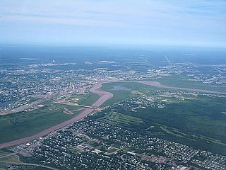
The Petitcodiac River is a river located in south-eastern New Brunswick, Canada. Local tourist businesses often refer to it as the "chocolate river" due to its distinctive brown mud floor and brown waters. Stretching across a meander length of 79 kilometres, the river traverses Westmorland, Albert, and Kings counties, draining a watershed area of about 2,071 square kilometres (800 sq mi). The watershed features valleys, ridges, and rolling hills, and is home to a diverse population of terrestrial and aquatic species. Ten named tributaries join the river in its course toward its mouth in Shepody Bay. Prior to the construction of a causeway in 1968, the Petitcodiac River had one of the world's largest tidal bores, which ranged from 1 to 2 metres (3.3–6.6 ft) in height and moved at speeds of 5 to 13 kilometres per hour (3.1–8.1 mph). With the opening of the causeway gates in April 2010, the river is flushing itself of ocean silts, and the bore is returning to its former size.
Hillsborough is a former village in Albert County in the province of New Brunswick, Canada. It was an incorporated village prior to 2023 but is now part of the much larger incorporated village of Fundy Albert.
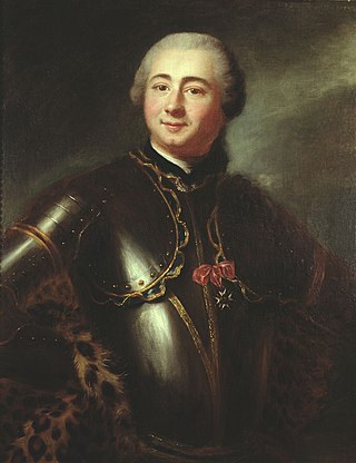
Charles Deschamps de Boishébert was a member of the Compagnies Franches de la Marine and was a significant leader of the Acadian militia's resistance to the Expulsion of the Acadians. He settled and tried to protect Acadians refugees along the rivers of New Brunswick. At Beaubears National Park on Beaubears Island, New Brunswick he settled refugee Acadians during the Expulsion of the Acadians.

Riverside-Albert is a disincorporated village in Fundy Albert, New Brunswick, Canada. It resides in the geographic parish of Hopewell in Albert County.
Route 114 is a 137.6 km (85.5 mi) Canadian secondary highway in southeastern New Brunswick.
Hopewell Cape is a Canadian village and headland in Albert County, New Brunswick at the northern end of Shepody Bay and the mouth of the Petitcodiac River.
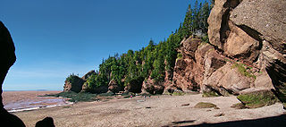
Shepody Bay is a tidal embayment, an extension of the Bay of Fundy in New Brunswick, Canada, which consists of 77 square kilometres (30 sq mi) of open water and 40 km2 (15 sq mi) of mudflats, with 4 km2 (1.5 sq mi) of saline marsh on the west, and eroding sand and gravel beaches covering an area of approximately 1 km2 (0.39 sq mi) on the eastern shore. The intertidal mudflats "support internationally important numbers of the crustacean Corophium volutator, the principal food source for millions of fall migrating shorebirds".

Beaubears Island is an island at the confluence of the Northwest Miramichi and Southwest Miramichi Rivers near Miramichi, New Brunswick. The island is most famous for being the site of an Acadian refugee camp during the French and Indian War. The camp was under the command of leader of the Acadian resistance to the expulsion, Charles Deschamps de Boishébert et de Raffetot.
The Battle of Petitcodiac was an engagement which occurred during the Bay of Fundy campaign of the French and Indian War. The battle was fought between the British colonial forces from Massachusetts and Acadian militiamen led by French officer Charles Deschamps de Boishébert et de Raffetot on September 4, 1755. It took place at the Acadian village of Village-des-Blanchard on the Petitcodiac River.

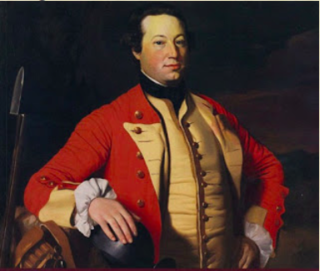
The St. John River campaign occurred during the French and Indian War when Colonel Robert Monckton led a force of 1150 British soldiers to destroy the Acadian settlements along the banks of the Saint John River until they reached the largest village of Sainte-Anne des Pays-Bas in February 1759. Monckton was accompanied by Captain George Scott as well as New England Rangers led by Joseph Goreham, Captain Benoni Danks, as well as William Stark and Moses Hazen, both of Rogers' Rangers.
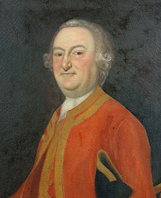
The Petitcodiac River campaign was a series of British military operations from June to November 1758, during the French and Indian War, to deport the Acadians that either lived along the Petitcodiac River or had taken refuge there from earlier deportation operations, such as the Ile Saint-Jean campaign. Under the command of George Scott, William Stark's company of Rogers Rangers, Benoni Danks and Gorham's Rangers carried out the operation.
The Bay of Fundy campaign occurred during the French and Indian War when the British ordered the Expulsion of the Acadians from Acadia after the Battle of Fort Beauséjour (1755). The campaign started at Chignecto and then quickly moved to Grand-Pré, Rivière-aux-Canards, Pisiguit, Cobequid, and finally Annapolis Royal. Approximately 7,000 Acadians were deported to the New England colonies.

The Gulf of St. Lawrence campaign occurred during the French and Indian War when British forces raided villages along present-day New Brunswick and the Gaspé Peninsula coast of the Gulf of Saint Lawrence. Sir Charles Hardy and Brigadier-General James Wolfe were in command of the naval and military forces respectively. After the siege of Louisbourg, Wolfe and Hardy led a force of 1,500 troops in nine vessels to the Gaspé Bay arriving there on September 5. From there they dispatched troops to Miramichi Bay, Grande-Rivière, Quebec and Pabos, and Mont-Louis, Quebec. Over the following weeks, Sir Charles Hardy took 4 sloops or schooners, destroyed about 200 fishing vessels and took about two hundred prisoners.

Hopewell is a geographic parish in eastern Albert County, New Brunswick, Canada.

Harvey is a geographic parish in southern Albert County, New Brunswick, Canada.
