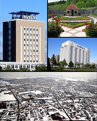
Eniwa is a city in Ishikari Subprefecture, Hokkaido, Japan. It is on the Ishikari plain, 8 km north of Chitose, and 26 km south of the prefectural capital Sapporo. It is reached through route 36 and the Chitose Railway Line. The town is separated into three major areas: Eniwa in the south, Megumino in the center, and Shimamatsu in the north.
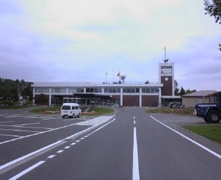
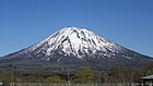
Kyōgoku is a town located in Shiribeshi Subprefecture, Hokkaido, Japan. Kyōgoku sits at the eastern foot of Mount Yōtei, an active stratovolcano volcano which dominates the skyline of the town.

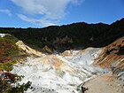
Shōwa-shinzan is a volcanic lava dome in the Shikotsu-Toya National Park, Hokkaido, Japan, next to Mount Usu. The mountain was created between 28 December 1943 and September 1945. Initially, a series of strong earthquakes shook the area, and wheat fields were rapidly uplifted. Lava broke through the surface and the current peak was created. The peak is now 398 m (1,306 ft) tall, and still actively smoking.

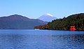
Mount Usu is an active stratovolcano in the Shikotsu-Tōya National Park, Hokkaido, Japan. It has erupted four times since 1900: in 1910, 1944–45, August 7, 1977, and on March 31, 2000. To the north lies Lake Tōya. Mount Usu formed on the southern rim of the caldera containing the lake.

Lake Tōya is a volcanic caldera lake in Shikotsu-Toya National Park, Abuta District, Hokkaidō, Japan. It is part of "Toya Caldera and Usu Volcano Global Geopark" which joins in Global Geoparks Network. The stratovolcano of Mount Usu lies on the southern rim of the caldera. The lake is nearly circular, being 10 kilometers in diameter from the eastwest and 9 kilometers from the northsouth. The town of Tōyako comprises most of the area surrounding the lake and the town of Sōbetsu is located on the eastern side.

Mount Yōtei is an active stratovolcano located in Shikotsu-Toya National Park, Hokkaidō, Japan. It is also called Yezo Fuji or Ezo Fuji (蝦夷富士), "Ezo" being an old name for the island of Hokkaido, because it resembles Mount Fuji. The mountain is also known as Makkari Nupuri (マッカリヌプリ). It is one of the 100 famous mountains in Japan.
Chitose is a city located in Ishikari Subprefecture, Hokkaido, Japan, and home to the New Chitose Airport, the biggest international airport in Hokkaido and closest airport to Sapporo, as well as the neighboring Chitose Air Base. As of February 1, 2024, the city had an estimated population of 97,919, with 52,196 households, and a population density of 165 persons per km². The total area is 594.50 km². The city was founded on July 1, 1958. The city is notable for having a Peace Pagoda, built by the Japanese Buddhist order Nipponzan Myohoji in 1978.

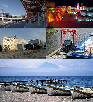
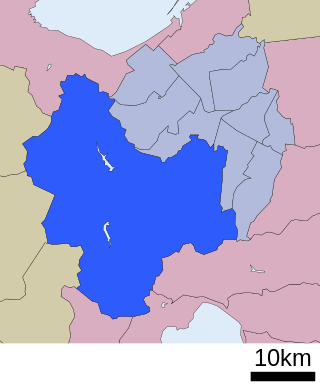
Tōyako is a town in Iburi Subprefecture, Hokkaido, Japan. It was formed on March 23, 2006, through the merger of the town of Abuta and the village of Tōya. As of 1 October 2020, the town has an estimated population of 8,442, and a population density of 47 persons per km2. The total area is 180.54 km2.

Lake Shikotsu is a caldera lake in Chitose, Hokkaidō, Japan. It is a part of the Shikotsu-Toya National Park.

Mount Tarumae is located in the Shikotsu-Toya National Park in Hokkaidō, Japan. It is located near both Tomakomai and Chitose towns and can be seen clearly from both. It is on the shores of Lake Shikotsu, a caldera lake. Tarumae is a 1,041 metre active andesitic stratovolcano, with a lava dome.
Minami-ku (南区) is one of the 10 wards in Sapporo, Hokkaidō, Japan. Minami-ku is directly translated as "south ward". Having the area of 657.48 km2 in total, Minami-ku occupies 60 percent of the area of Sapporo.

The Usuzan Ropeway is Japanese aerial lift line in Sōbetsu, Hokkaidō, operated by Wakasa Resort. Opened in 1965, the line climbs Mount Usu, the active volcano in Shikotsu-Tōya National Park. The observatory has a view of Lake Tōya, Shōwa Shinzan, and the central crater of Mount Usu.

The Kamori Kankō (加森観光) is a tourist company operating hotels and amusement parks, mainly in Hokkaidō, Japan. The company is headquartered in Sapporo. Its most important resort facility has been Rusutsu Resort. The company was founded in 1981, and its group rapidly expanded after 1998, through mergers of underperforming facilities.

Mount Eniwa is an active volcano located in Shikotsu-Toya National Park in Hokkaidō, Japan. It sits opposite Mount Tarumae and Mount Fuppushi on the shores of Lake Shikotsu, the caldera lake that spawned the volcanoes. Mount Eniwa is the tallest of the three volcanoes.

Mount Fuppushi is a dormant volcano located in Shikotsu-Toya National Park in Hokkaidō, Japan. It sits adjacent to Mount Tarumae and opposite Mount Eniwa. Mount Fuppushi is on the south shore of Lake Shikotsu, the caldera lake that spawned the volcanoes.

Mount Morappu is a mountain located in Shikotsu-Toya National Park in Hokkaidō, Japan. It sits on the shore of Lake Shikotsu, a caldera lake. It also hosts a nationally established ski slope.

Mount Monbetsu is a mountain located in Shikotsu-Toya National Park in Hokkaidō, Japan. It sits on the shore of Lake Shikotsu, a caldera lake. It also hosts a radio relay station.

Lake Kuttara is a nearly circular caldera lake in Shiraoi, Hokkaidō, Japan. It is part of Shikotsu-Tōya National Park. The lake is recognized as having the best water quality in all of Japan. With a transparency of 19 metres (62 ft), the lake ranks second to Lake Mashū according to the Ministry of the Environment.

Mount Horohoro is a mountain in Hokkaidō. It is located on the border between Date and Shiraoi in Hokkaidō, Japan. It is the tallest mountain in the Iburi subprefecture. From the top, Lake Tōya, Lake Shikotsu, Mount Yōtei, Mount Eniwa, and even the outskirts of Sapporo are all visible.
National parks in Hokkaido are 6 protected areas. Those are: Rishiri Rebun Sarobetsu National Park, Shiretoko National Park, Akan Mashu National Park, Kushiro Shitsugen National Park, Daisetsuzan National Park, and Shikotsu Toya National Park. Natural Parks, including the national park areas, are established in about 10% of the total land area of Hokkaido Prefecture.