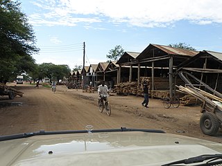
Shinyanga, also known as Mji wa Shinyanga in the national language, is a city in northern Tanzania. The city is the location of the regional headquarters of Shinyanga Region as well as the district headquarters of Shinyanga Urban District. The region and district are named after the town.

Kwimba District is one of the seven districts of the Mwanza Region of Tanzania. It is bordered to the north by the Magu District, to the east by Maswa District and Kishapu District, to the south by Shinyanga Rural District, and to the west by Misungwi District. The district seat is at Ngudu. Sumve is another important settlement in Kwimba District, hosting a hospital and large church.

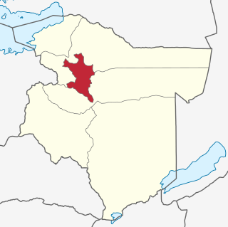
Shinyanga Region is one of Tanzania's 31 administrative regions. The region covers a land area of 18,555 km2 (7,164 sq mi). The region is comparable in size to the combined land area of the nation state of Fiji. The region is bordered to the north by the Mwanza, Mara, and Kagera Regions and to the south by the Tabora Region. In addition, the Kigoma Region borders the region to the west, and the Simiyu Region and a sliver of Singida Region to the east. The regional capital is the municipality of Shinyanga. According to the 2022 national census, the region had a population of 2,241,299.

Misungwi District is one of the seven districts of the Mwanza Region of Tanzania. It is bordered to the north by Nyamagana District and Magu District, to the east by Kwimba District, to the south by Shinyanga Rural District and to the west by Nyang'hwale District and Lake Victoria. Misungwi is often spelled with an extra 's' to make it Missungwi. The administrative centre is in the town of Misungwi.

Bariadi District is one of the five districts of the Simiyu Region of Tanzania, East Africa. As of 2002, the population was 605,509.

Meatu District is one of the five districts of the Simiyu Region of Tanzania. It is bordered to the north by the Itilima District, to the west by the Maswa District and Shinyanga Region to the east by the Arusha Region, to the southeast by the Manyara Region and to the south by the Singida Region. Its district capital is the town of Mwanhuzi.
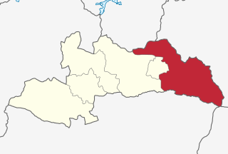
Kishapu District is one of the three districts of the Shinyanga Region of Tanzania. It is bordered to the north by the Maswa District, to the south by the Tabora Region, to the east by the Meatu District and to the west by the Shinyanga Rural and Urban Districts.

Shinyanga Urban District is one of the eight districts of the Shinyanga Region of Tanzania and includes the city of Shinyanga. It is bordered to the north by the Mwanza Region, to the south by the Shinyanga Rural District, to the east by the Kishapu District and to the west by the Kahama Urban District.
Nzega District is one of the seven districts of the Tabora Region of Tanzania. It is bordered to the north by Shinyanga Region, to the south and southwest by Uyui District and to the east by Igunga District. Its administrative seat is the town of Nzega.

Uyui District is one of the seven districts of the Tabora Region of Tanzania. It is bordered to the north by Nzega District and Igunga District as well as by the Shinyanga Region, to the south by Sikonge District, to the west by Urambo District and Kaliua District, and to the east by the Singida Region. Tabora Urban District is an enclave within the Uyui District. Its administrative seat is the city of Tabora.
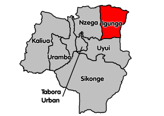
Igunga is one of the seven districts of the Tabora Region of Tanzania. It is bordered to the north by the Shinyanga Region, to the east by the Singida Region, to the south by the Uyui District and to the west by the Nzega District. Its administrative seat is the town of Igunga. Igunga is now divided by two Constituencys: Igunga Constituency and Manonga Constituency, whereby Manonga town is Choma Chankola. Igunga is the second district in production

Iramba is one of the six districts of the Singida Region of central Tanzania. It is bordered to the Northwest by the Shinyanga Region, to the North by Simiyu Region, to the east by the Mkalama District, to the South by Ikungi District and to the West by the Tabora Region. Its administrative seat is the town of Kiomboi.

Geita District is located in the Geita Region of Tanzania. According to the 2022 census, the population of the district was 1,035,214. The district is bordered to the east by Mwanza Region and Nyang'hwale District, to the south by Shinyanga Region and Mbogwe District, and to the west by Chato District.
The main natural resources in Tanzania are land, rivers, lakes the ocean, and forests/woodlands. Natural resources are used for crops cultivation, grazing, wildlife, wood, fishing and minerals' mining.

Geita Region is one of Tanzania's 31 administrative regions. The region covers an area of 20,054 km2 (7,743 sq mi)."Geita Region Size". The region is comparable in size to the combined land area of the nation state of Slovenia. Geita Region is bordered to the east by Lake Victoria, Mwanza Region and Shinyanga Region. The region is bordered by Tabora Region and Kigoma Region to the south and south west respectively. Lastly, Gieta is borders Kagera Region to the west.
Bariadi is a Tanzanian town and regional capital of Simiyu Region, and the is also administrative seat of Bariadi District. Bariadi also refers to Bariadi Ward, another administrative unit in the district.

Nyang'hwale District is one of the five districts of Geita Region of Tanzania. Its administrative centre is the village Kharumwa. It is bordered to the north by Sengerema District, to the east by Misungwi District and Shinyanga Rural District, to the south by Kahama Rural District, and to the west by Geita District.
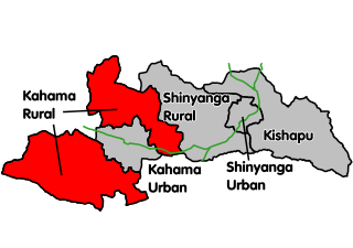
Kahama Rural District is a former districts of the Shinyanga Region of Tanzania. Its administrative centre was the town of Kahama. The district consists of two separate parts, divided by Kahama Urban District. The area to the northeast is Msalala District, while the part to the southwest is Ushetu Council. In 2012 the two districts were officially formed.
Bukomela is an administrative ward in Kahama Rural District, Shinyanga Region, Tanzania. In 2016 the Tanzania National Bureau of Statistics report there were 7,049 people in the ward, from 6,492 in 2012.

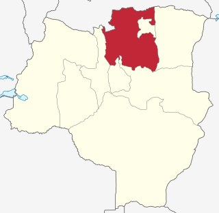
Msalala District is a district council in the Shinyanga Region of Tanzania's lake zone established in 2012. The district lies in the middle of the region just north-east of the town of Kahama.
