Transport in Tanzania includes road, rail, air and maritime networks. The road network is 86,472 kilometres (53,731 mi) long, of which 12,786 kilometres (7,945 mi) is classified as trunk road and 21,105 kilometres (13,114 mi) as regional road. The rail network consists of 3,682 kilometres (2,288 mi) of track. Commuter rail service is in Dar es Salaam only. There are 28 airports, with Julius Nyerere International being the largest and the busiest. Ferries connect Mainland Tanzania with the islands of Zanzibar. Several other ferries are active on the countries' rivers and lakes.
Shinyanga, also known as Mji wa Shinyanga in the national language, is a city in northern Tanzania. The city is the location of the regional headquarters of Shinyanga Region as well as the district headquarters of Shinyanga Urban District. The region and district are named after the town.
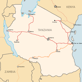
The Central Line, formerly known as the Tanganyika Railway is the most important railway line in Tanzania, apart from TAZARA. It runs west from Dar es Salaam to Kigoma on Lake Tanganyika via Dodoma. A branch leads to Mwanza on Lake Victoria.

Mwanza Region is one of Tanzania's 31 administrative regions. The region covers a land area of 25,233 km2 (9,743 sq mi). The region is comparable in size to the combined land area of the nation state of North Macedonia. Mwanza Region is bordered to the north through Lake Victoria by the Kagera Region and Mara Region, to the east by Simiyu Region, to the south by the Shinyanga Region and to the west by Geita Region. The regional capital is the city of Mwanza. According to the 2022 national census, the region had a population of 3,699,872 and national census of 2012 had 2,772,509. Mwanza Region is the second region with high population in Tanzania after Dar es Salaam Region.

Shinyanga Region is one of Tanzania's 31 administrative regions. The region covers a land area of 18,555 km2 (7,164 sq mi). The region is comparable in size to the combined land area of the nation state of Fiji. The region is bordered to the north by the Mwanza, Mara, and Kagera Regions and to the south by the Tabora Region. In addition, the Kigoma Region borders the region to the west, and the Simiyu Region and a sliver of Singida Region to the east. The regional capital is the municipality of Shinyanga. According to the 2022 national census, the region had a population of 2,241,299.

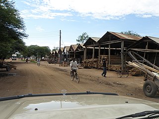
Kahama Urban District is one of the five districts of the Shinyanga Region of Tanzania. Its administrative centre is the town of Kahama. It is bordered to the north and south by Kahama Rural District, to the east by Nzega District and to the west by Bukombe District.
As of 2021, there are 31 regions of Tanzania which are divided into 184 districts.

Geita Region is one of Tanzania's 31 administrative regions. The region covers an area of 20,054 km2 (7,743 sq mi)."Geita Region Size". The region is comparable in size to the combined land area of the nation state of Slovenia. Geita Region is bordered to the east by Lake Victoria, Mwanza Region and Shinyanga Region. The region is bordered by Tabora Region and Kigoma Region to the south and south west respectively. Lastly, Gieta is borders Kagera Region to the west.
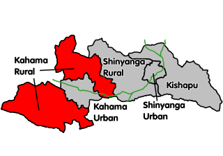
Kahama Rural District is a former districts of the Shinyanga Region of Tanzania. Its administrative centre was the town of Kahama. The district consists of two separate parts, divided by Kahama Urban District. The area to the northeast is Msalala District, while the part to the southwest is Ushetu Council. In 2012 the two districts were officially formed.
The Tanzanian Championship is the second tier of league football in Tanzania. The league is made up of sixteen teams that play thirty rounds, home and away.The league was formed in 1930.

Bukoba Rural District is one of the eight districts of the Kagera Region of Tanzania. It is bordered to the north by Missenyi District, to the east by Lake Victoria and Bukoba Urban District, to the south by Muleba District and to the west by Karagwe District. Its administrative seat is Bukoba town.
Kahama is an administrative ward in Kahama Urban District, Shinyanga Region, Tanzania with a postcode number 37304.In 2016 the Tanzania National Bureau of Statistics report there were 7,189 people in the ward, from 6,621 in 2012.
The Isaka–Kigali Standard Gauge Railway is a planned railway line linking the town of Isaka in Tanzania to the city of Kigali in Rwanda.

The Tanzania Standard Gauge Railway is a railway system, under construction, linking the country to the neighbouring countries of Rwanda, Uganda and Burundi, and through these to the Democratic Republic of the Congo, as part of the East African Railway Master Plan. The new standard gauge railway (SGR), is intended to replace the old, inefficient metre-gauge railway system.

Mtwara Mikindani Municipal District Council is one of eight regional councils of the Mtwara Region in Tanzania. It is bordered to the north by the Lindi Region, to the east by the Indian Ocean and to the south and west by the Mtwara District. In 2016, the municipality has a total population of 113,732.

Nanyamba Town, is a district established in 2016 of the Mtwara Region in the southern coastal Tanzania. Nanyamba is in the eastern portion of the Mtwara Region, near the coast.

Newala Town, is a district level town council in the Mtwara Region in the southern coastal Tanzania. The town is in the south central portion of the Mtwara Region, on the northern bank of the Ruvuma River that is the border between Tanzania and Mozambique. The district was established on the 25th of September, 2015.

Buchosa District, is a district in the Mwanza Region in the southern coastal Tanzania. The district is on the south shore of Lake Victoria west of the city of Mwanza and north of the Geita Region. Much of the district is large islands in the lake. The district was established in 2015.

Itigi District is a district council in the Singida Region of central Tanzania established in 2015. The district lies in the south-western portion of the Singida Region with 279,069 people and encompasses a large area mostly made up of protected game reserves.

Ushetu District is a district council in the Shinyanga Region of Tanzania's lake zone established in 2012. The district lies in west most portion of the region just south and west of the town of Kahama.


