Transport in Tanzania includes road, rail, air and maritime networks. The road network is 86,472 kilometres (53,731 mi) long, of which 12,786 kilometres (7,945 mi) is classified as trunk road and 21,105 kilometres (13,114 mi) as regional road. The rail network consists of 3,682 kilometres (2,288 mi) of track. Commuter rail service is in Dar es Salaam only. There are 28 airports, with Julius Nyerere International being the largest and the busiest. Ferries connect Mainland Tanzania with the islands of Zanzibar. Several other ferries are active on the countries' rivers and lakes.
Manyara Region is one of Tanzania's 31 administrative regions. The regional capital is the town of Babati. According to the 2012 national census, the region had a population of 1,425,131, which was lower than the pre-census projection of 1,497,555. For 2002–2012, the region's 3.2 percent average annual population growth rate was tied for the third highest in the country. It was also the 22nd most densely populated region with 32 people per square kilometre.
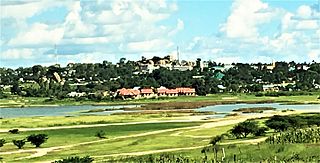
Shinyanga, also known as Mji wa Shinyanga in the national language, is a city in northern Tanzania. The city is the location of the regional headquarters of Shinyanga Region as well as the district headquarters of Shinyanga Urban District. The region and district are named after the town.

Mtwara is the capital city of Mtwara Region in southeastern Tanzania. In the 1940s, it was planned and constructed as the export facility for the disastrous Tanganyika groundnut scheme, but was somewhat neglected when the scheme was abandoned in 1951. The city is spread out over a large area planned to accommodate up to 200,000 people. The present population is around 141,000. As part of the development associated with the failed Tanganyika groundnut scheme, Mtwara features a deep-water port that can accommodate ocean-going vessels, and a range of large municipal buildings, including a post office. Recent improvements in the port made it possible for big container ships to berth there.

Tabora Urban is one of the seven districts in the Tabora Region of Tanzania. This district is mostly the city of Tabora and its suburbs. It is bordered almost completely by the Uyui District. It has a small border with Nzega District to the north. Its administrative seat is the city of Tabora.

Singida Urban District is one of the six districts of the Singida Region of Tanzania. It is bordered to the south and west by the Ikungi District and to the north and east by the Singida Rural District. Its administrative seat is the town of Singida.

Manyoni District is one of the six districts in the Singida Region of Tanzania. The district capital is the town of Manyoni. The district is bordered to the north by the Ikungi District, to the east by the Dodoma Region, to the south by the Iringa Region, to the southwest by the Mbeya Region and to the west by the Tabora Region. In 2015 the Itigi District was created from the Manyoni District, separating the Itigi Division that was the large portion of the south western of the district.
Isaka is a small town and station on the narrow-gauge Mwanza railway line of Tanzania which connects to the seaport of Dar es Salaam.
Itigi is a town in central Tanzania. It is located in Itigi District of the Singida Region.

Dodoma City District, officially the Dodoma Municipal Council is one of seven districts of the Dodoma Region of Tanzania. It is bordered to the west by Bahi District, and to the east by Chamwino District. It covers an area of 2,607 km2 (1,007 sq mi). The district is comparable in size to the land area of Luxembourg. Its administrative seat is the city of Dodoma, also the legislative capital of Tanzania. The 2012 National Tanzania Census states the population for the district as 410,956.

Geita Region is one of Tanzania's 31 administrative regions. The region covers an area of 20,054 km2 (7,743 sq mi)."Geita Region Size". The region is comparable in size to the combined land area of the nation state of Slovenia. Geita Region is bordered to the east by Lake Victoria, Mwanza Region and Shinyanga Region. The region is bordered by Tabora Region and Kigoma Region to the south and south west respectively. Lastly, Gieta is borders Kagera Region to the west.

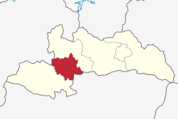
Singida Rural District is one of the six districts of the Singida Region of Tanzania. It is bordered to the north by Mkalama District, to the east by Manyara Region and Dodoma Region, to the south by Ikungi District and to the west by Singida Urban District. Its administrative seat is the town of Singida.

Muheza is a town and capital of Muheza District in the Tanga Region of Tanzania. In the Muheza district, the town covers five wards; Majengo ward to the east, Tanganyika ward to the north, Genge and Majengo ward to the east, and Kwemkabala ward to the west. Paved trunk road T13 from Segera to the Kenyan border passes through Muheza town. The town also has a station on the Tanga-Arusha Railway.

Nyang'hwale District is one of the five districts of Geita Region of Tanzania. Its administrative centre is the village Kharumwa. It is bordered to the north by Sengerema District, to the east by Misungwi District and Shinyanga Rural District, to the south by Kahama Rural District, and to the west by Geita District.
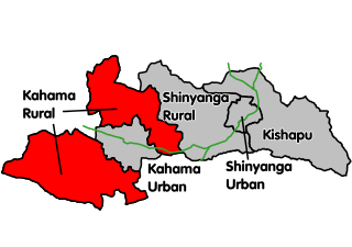
Kahama Rural District is a former districts of the Shinyanga Region of Tanzania. Its administrative centre was the town of Kahama. The district consists of two separate parts, divided by Kahama Urban District. The area to the northeast is Msalala District, while the part to the southwest is Ushetu Council. In 2012 the two districts were officially formed.

Mbogwe District is one of the five districts of Geita Region of Tanzania. It is bordered to the north by Chato District and Geita District, to the east by Kahama Rural District and Kahama Urban District, to the south by Kahama Rural District, and to the west by Bukombe District.
Singida is a city in central Tanzania. The city is the location of the regional headquarters of Singida Region as well as the district headquarters of Singida Urban District. The region and district are named after the city.
Lamadi is a town and a ward in Busega District of Simiyu Region, Tanzania. It is located on the shore of Lake Victoria. On 'dala dala' mini-busses in the area, the town's name is sometimes misspelled as 'Ramadi' the town have street (mitaa) that are Itongo, Makanisani, Majengo, Msekula Road, Mwalukonge and three village that are Lukungu, Mwabayanda and Kalago The main tribes in Lamadi Town are Sukuma, Jita,Kurya,Zanaki,Luo and Waha from Kigoma. The people like to visit Lamadi Town because is fevered by many attraction.

Bukoba Urban District is one of the eight districts of the Kagera Region of Tanzania. It is bordered to east by Lake Victoria and to the west by Bukoba Rural District. Its administrative seat is the town of Bukoba.

Msalala District is a district council in the Shinyanga Region of Tanzania's lake zone established in 2012. The district lies in the middle of the region just north-east of the town of Kahama.