Ushetu District

Last updated

Ushetu
Ushetu District in Shinyanga 2022.svg
Ushetu District location in the Shinyanga Region
Coordinates: 4°06′24″S32°24′18″E / 4.1068°S 32.405°E / -4.1068; 32.405 Coordinates: 4°06′24″S32°24′18″E / 4.1068°S 32.405°E / -4.1068; 32.405
Country Flag of Tanzania.svg  Tanzania
Region Shinyanga Region
District Ushetu District
Established [1] 23 November 2012
HeadquartersKisuke
Government
  TypeCouncil
  Chairman [2] Gagi Lala Gagi
  Director [2] Linno Pius Mwageni
Area
[3] [4] :10
  Total5,311 km2 (2,051 sq mi)
  Water22 km2 (8 sq mi)
Population
 (2016) [5] :132
  Total296,515
  Density56/km2 (140/sq mi)
Time zone UTC+3 (EAT)
Postcode [6]
37xxx
Area code 028
Website District Website

Ushetu District is a district council in the Shinyanga Region of Tanzania's lake zone established in 2012. The district lies in west most portion of the region just south and west of the town of Kahama.

Contents

History

The district was created on 23 November 2012 by splitting the Kahama District into one new town council of Kahama Municipality, and two new district councils of Msalala District and Ushetu District. The official inauguration of the district was on 1 July 2013. [7] [8] :1 [4] :9

Geography

The district lies in the west of the Shinyanga Region to the south and east of Kahama Town. To the north-east of the district is Kahama Town of the Shinyanga Region the north is Mbogwe District and west Bukombe District both of the Geita Region. To the east and south is the Tabora Region with the Nzega District to the east, and Uyui District and Kaliua District to the south from east to west respectively. The district covers an area of 5,311 square kilometres (2,051 sq mi) of which only 22 km2 (8.5 sq mi) is water. [1] [9] :12 [4] :10

Climate

The districts climate is tropical savanna climate with the Aw Koppen-Geiger system classification. The average temperature is 23 °C (73 °F) with an average rainfall of 973 millimetres (38.3 in). [10]

Administrative divisions

The district has the two division of Mweli and Dakama, 20 wards, and 112 villages. [1] [9] :12

Wards (2016 population) [5] :131

  • Bukomela (7,049)
  • Bulungwa (26,757)
  • Chambo (15,762)
  • Chona (20,067)
  • Idahina (25,992)
  • Igunda (7,163)
  • Igwamanoni (16,180)
  • Kinamapula (13,785)
  • Kisuke (5,114)
  • Mapamba (6,811)
  • Mpunze (10,140)
  • Nyamilangano (6,251)
  • Nyankende (15,761)
  • Sabasabini (12,556)
  • Ubagwe (17,997)
  • Ukune (12,723)
  • Ulewe (19,880)
  • Ulowa (20,881)
  • Ushetu (19,043)
  • Uyogo (16,604)

Demographics

In 2016 the Tanzania National Bureau of Statistics report there were 296,515 people in the district, from 273,075 in 2012. People of the district are of the tribes of Wasukuma, Wasumbwa, and Wanyamwezi with small populations of Waha, and Wahangaza. [5] :131 [1]

In 2012, the district had 43,497 households of 6 to 7 people and yearly population growth rate of 3.3%. [4] :11

Economy

The Ushetu District has 2,149 square kilometres (830 sq mi) of agricultural land, which predominantly used to grow maize, cotton and rice. There is 1,044.4 km2 (403.2 sq mi) of grazing land that is used mostly by cattle and goats, as well as a small number of sheep. [4] :10 [11]

The district has 2,110 square kilometres (810 sq mi) of forest reserve for forestry, also which includes 900 km2 (350 sq mi) of protected areas such as the Kigosi National Park which can be used for beekeeping and tourism. [12]

Education

There are 102 primary schools, and 18 secondary schools in Ushetu District. [9] :31

Health

The district has one hospital, three health care centers, and 25 dispensaries. In 2019, 165,111 (56%) of the population had access to safe, clean, and reliable water. [9] :30-32

Roads

There are no paved roads, or national roads in the district. There are 221 kilometres (137 mi) of gravel, and 664 km (413 mi) of dirt roads, for a 885 km (550 mi) road network. [13] [9] :5

Related Research Articles

<span class="mw-page-title-main">Ludewa District</span> District of Njombe Region, Tanzania

Ludewa District is one of six districts in the Njombe Region in Tanzania, East Africa. Prior to 2012, the district was one of the seven districts of Iringa Region. The town of Ludewa is the administrative seat of the district. A hospital is located in the city. The district is bordered to the north by the Njombe Rural District and Makete District, to the southeast by the Ruvuma Region and to the southwest by the country of Malawi across Lake Nyasa.

<span class="mw-page-title-main">Shinyanga</span> City in Shinyanga Region, Tanzania

Shinyanga, also known as Shinyanga Mji in the local Swahili language, is a city in northern Tanzania. The city is the location of the regional headquarters of Shinyanga Region as well as the district headquarters of Shinyanga Urban District. The region and district are named after the town.

<span class="mw-page-title-main">Mwanza Region</span> Region of Tanzania

Mwanza Region is one of Tanzania's 31 administrative regions The regional capital is the city of Mwanza. Mwanza Region is home to Ukerewe Island, the largest lake island in Africa as well as Saanane Island National Park, the smallest national park in Tanzania.

<span class="mw-page-title-main">Shinyanga Region</span> Region of Tanzania

Shinyanga Region is one of Tanzania's 31 administrative regions. The regional capital is the municipality of Shinyanga.

Meatu District District in Simiyu Region, Tanzania

Meatu District is one of the five districts of the Simiyu Region of Tanzania. It is bordered to the north by the Itilima District, to the west by the Maswa District and Shinyanga Region to the east by the Arusha Region, to the southeast by the Manyara Region and to the south by the Singida Region. Its district capital is the town of Mwanhuzi.

As of 2021,there are 31 regions of Tanzania which are divided into 184 districts.

<span class="mw-page-title-main">Kondoa Mjini</span> Town in Kondoa District, Dodoma Region, Tanzania

Kondoa is a town and administrative ward in the Kondoa District of the Dodoma Region of Tanzania.

<span class="mw-page-title-main">Geita Region</span> Region of Tanzania

Geita Region is one of Tanzania's 31 administrative regions. The region covers an area of 20,054 km2 (7,743 sq mi). The region is comparable in size to the combined land area of the nation state of Slovenia. Geita Region is bordered to the east by Lake Victoria, Mwanza Region and Shinyanga Region. The region is bodered by Tabora Region and Kigoma Region to the south and south west respectively. Lastly, Gieta is borders Kagera Region to the west.

<span class="mw-page-title-main">Kaliua District</span> District in Tabora Region, Tanzania

Kaliua District is one of the seven districts of the Tabora Region of Tanzania. It is bordered to the north by Kahama and Ushetu Districts, to the east by Uyui District and Urambo District, to the south by Katavi Region and to the west by Uvinza District and Geita Region. Its administrative seat is the town of Kaliua.

<span class="mw-page-title-main">Kahama Rural District</span> District in Shinyanga Region, Tanzania

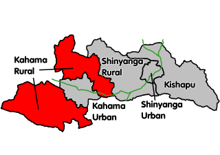
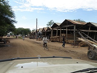
Kahama Rural District is one of the five districts of the Shinyanga Region of Tanzania. Its administrative centre is the town of Kahama. The district consists of two separate parts, divided by Kahama Urban District. The area to the northeast is Msalala District, while the part to the southwest is Ushetu Council.

<span class="mw-page-title-main">Bukoba Urban District</span> District in Kagera Region, Tanzania

Bukoba Urban District is one of the eight districts of the Kagera Region of Tanzania. It is bordered to east by Lake Victoria and to the west by Bukoba Rural District. Its administrative seat is the town of Bukoba.

Kahama is an administrative ward in Kahama Urban District, Shinyanga Region, Tanzania with a postcode number 37304.In 2016 the Tanzania National Bureau of Statistics report there were 7,189 people in the ward, from 6,621 in 2012.

<span class="mw-page-title-main">Mtwara-Mikindani District</span> District of Mtwara Region, Tanzania

Mtwara Mikindani Municipal District Council is one of eight regional councils of the Mtwara Region in Tanzania. It is bordered to the north by the Lindi Region, to the east by the Indian Ocean and to the south and west by the Mtwara District. In 2016, the municipality has a total population of 113,732.

<span class="mw-page-title-main">Nanyamba Town</span> District in Mtwara Region of Tanzania

Nanyamba Town, is a district established in 2016 of the Mtwara Region in the southern coastal Tanzania. Nanyamba is in the eastern portion of the Mtwara Region, near the coast.

<span class="mw-page-title-main">Newala Town</span> District in Mtwara, Tanzania

Newala Town, is a district level town council in the Mtwara Region in the southern coastal Tanzania. Newala Town is in the south central portion of the Mtwara Region, on the northern bank of the Ruvuma River that is the border between Tanzania and Mozambique. The district was established on the 25th of September, 2015.

<span class="mw-page-title-main">Buchosa District</span> District in Mwanza, Tanzania

Buchosa District, is a district in the Mwanza Region in the southern coastal Tanzania. The district is on the south shore of Lake Victoria west of the city of Mwanza and north of the Geita Region. Much of the district is large islands in the lake. The district was established in 2015.

<span class="mw-page-title-main">Itigi District</span> District in Singida, Tanzania

Itigi District is a district council in the Singida Region of central Tanzania established in 2015. The district lies in the south-western portion of the Singida Region with 123,515 people and encompasses a large area mostly made up of protected game reserves.

<span class="mw-page-title-main">Msalala District</span> District in Shinyanga, Tanzania

Msalala District is a district council in the Shinyanga Region of Tanzania's lake zone established in 2012. The district lies in the middle of the region just north-east of the town of Kahama.

<span class="mw-page-title-main">Mpimbwe District</span> District in Katavi, Tanzania

Mpimbwe District is a district council in the Katavi Region of Tanzania's Southern Highlands established in 2012. The district lies in the south of the region on Lake Rukwa.

<span class="mw-page-title-main">Nsimbo District</span> District in Katavi, Tanzania

Nsimbo District is a district council in the Katavi Region of Tanzania's Southern Highlands established in 2012. The district lies in the middle of the region east of the city of Mpanda. It is a tropical environment of mostly forest reserves and agricultural economy.

References

  1. 1 2 3 4 "Historia". ushetudc.go.tz (in Swahili). Kisuke: Ushetu District Council. Archived from the original on 24 June 2022. Retrieved 10 September 2022.
  2. 1 2 "Halmashauri ya Wilaya ya Ushetu". ushetudc.go.tz (in Swahili). Kisuke: Ushetu District Council. Archived from the original on 21 July 2022. Retrieved 10 September 2022.
  3. "Takwimu". ushetudc.go.tz (in Swahili). Kisuke: Ushetu District Council. Archived from the original on 24 June 2022. Retrieved 10 September 2022.
  4. 1 2 3 4 5 "Ushetu District Council Strategic Plan" (PDF). ushetudc.go.tz. Kisuke: Ushetu District Council. 2013. Archived (PDF) from the original on 24 June 2022. Retrieved 10 September 2022.
  5. 1 2 3 2016 Makadirio ya Idadi ya Watu katika Majimbo ya Uchaguzi kwa Mwaka 2016, Tanzania Bara [Population Estimates in Administrative Areas for the Year 2016, Mainland Tanzania](PDF) (Report) (in Swahili). Dar es Salaam, Tanzania: National Bureau of Statistics. 1 April 2016. Archived (PDF) from the original on 27 December 2021. Retrieved 3 July 2022.
  6. "Shinyanga Postcodes" (PDF). Tanzania Communications Regulatory Authority. Archived (PDF) from the original on 29 July 2022. Retrieved 16 August 2022.
  7. "JPM uplifts Kahama to Municipal status". The Guardian . Kahama. 29 January 2021. Archived from the original on 17 September 2021. Retrieved 10 September 2022.
  8. "Ushetu District Council Investment Profile" (PDF). ushetudc.go.tz. Kisuke: Ushetu District Council. 2017. Archived (PDF) from the original on 24 June 2022. Retrieved 10 September 2022.
  9. 1 2 3 4 5 "Shinyanga Region Investment Guide" (PDF). shinyanga.go.tz. Shinyanga: United Nations Development Programme. 2020. Archived (PDF) from the original on 19 June 2022. Retrieved 7 September 2022.
  10. "Climate Ushetu (Tanzania)". climate-data.org (in English and German). Germany: Climate-data. Archived from the original on 3 April 2022. Retrieved 10 September 2022.
  11. "Kilimo na Ufugaji". ushetudc.go.tz (in Swahili). Kisuke: Ushetu District Council. Archived from the original on 24 June 2022. Retrieved 10 September 2022.
  12. "Shughuli za Uwindaji na Mazao ya Misitu" (in Swahili). Kisuke: Ushetu District Council. Archived from the original on 24 June 2022. Retrieved 10 September 2022.
  13. "Shinyanga Region Roads Network" (PDF). tanroads.go.tz. Dodoma, Tanzania: TANROADS. Archived (PDF) from the original on 22 June 2022. Retrieved 8 September 2022.