Related Research Articles

Shirakawa is a city located in Fukushima Prefecture, Japan. As of 1 April 2020, the city had an estimated population of 59,393 in 23,546 households and a population density of 190 persons per km2. The total area of the city was 305.3 square kilometres (117.9 sq mi).

The Japanese dry garden or Japanese rock garden, often called a zen garden, is a distinctive style of Japanese garden. It creates a miniature stylized landscape through carefully composed arrangements of rocks, water features, moss, pruned trees and bushes, and uses gravel or sand that is raked to represent ripples in water. Zen gardens are commonly found at temples or monasteries. A zen garden is usually relatively small, surrounded by a wall or buildings, and is usually meant to be seen while seated from a single viewpoint outside the garden, such as the porch of the hojo, the residence of the chief monk of the temple or monastery. Many, with gravel rather than grass, are only stepped into for maintenance. Classical zen gardens were created at temples of Zen Buddhism in Kyoto during the Muromachi period. They were intended to imitate the essence of nature, not its actual appearance, and to serve as an aid for meditating about the true meaning of existence.

Shirakawa is a town located in Kamo District, Gifu Prefecture, Japan. As of 1 January 2019, the town had an estimated population of 8,288 and a population density of 36 persons per km2, in 3159 households. The total area of the town was 237.90 square kilometres (91.85 sq mi).

Hideki Shirakawa is a Japanese chemist, engineer, and Professor Emeritus at the University of Tsukuba and Zhejiang University. He is best known for his discovery of conductive polymers. He was co-recipient of the 2000 Nobel Prize in Chemistry jointly with Alan MacDiarmid and Alan Heeger.
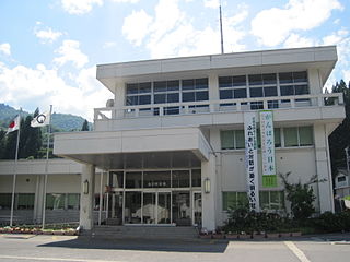
Shirakawa is a village located in Ōno District, Gifu Prefecture, Japan. It is best known for being the site of Shirakawa-gō, a small, traditional village showcasing a building style known as gasshō-zukuri. Together with Gokayama in Nanto, Toyama, it is one of UNESCO's World Heritage Sites.

Ten-ei is a village located in Fukushima Prefecture, Japan. As of 1 January 2020, the village had an estimated population of 5,258 in 1717 households, and a population density of 23 persons per km². The total area of the village was 225.52 square kilometres (87.07 sq mi).

Nishigō is a village located in Fukushima Prefecture, Japan. As of 1 March 2020, the village had an estimated population of 20,351 in 7618 households and a population density of 110 persons per km2. The total area of the village was 192.06 square kilometres (74.15 sq mi)..

Shin-Shirakawa Station (新白河駅) is a railway station in the village of Nishigō, Fukushima, Japan, operated by East Japan Railway Company.
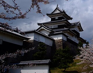
Komine Castle is a Japanese castle located in what is now the city of Shirakawa, southern Fukushima Prefecture, Japan. Throughout the middle to later Edo period, Komine Castle was home to the Abe clan, daimyō of Shirakawa Domain. It was also referred to as Shirakawa-Komine Castle or simply Shirakawa Castle. The castle is one of the 100 Fine Castles of Japan, and in 2007 was designated a National Historic Site. It should not be confused with the older Shirakawa Castle also located in Shirakawa, Fukushima, also known as Karame-jō (搦目城) or Yūki-Shirakawa-jō (結城白川城). The castle grounds are also a noted venue for viewing sakura in spring.

The Shō River has its source in Mount Eboshi in the Shōkawa-chō area of Takayama, Gifu Prefecture, Japan. After flowing for 115 km (71 mi) through the northern part of Gifu Prefecture and the western part of Toyama Prefecture, it empties into Toyama Bay.
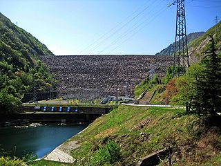
Miboro Dam is a dam on the Shō River in Shirakawa, in Gifu Prefecture Japan. It supports a 256 MW hydroelectric power station. Of the nine dams on the Shō River, it is the furthest upstream.

Sakaigawa Dam is a dam in Nanto, Toyama Prefecture and Shirakawa, Gifu Prefecture, Japan. It is named for the Sakaigawa River, upon which it is built. The dam has an associated 27 MW hydroelectric power station about 2.9 km (1.8 mi) downstream. It was commissioned in June 1993.
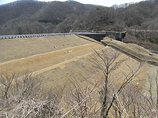
Hatori Dam is a dam in Ten'ei, Fukushima Prefecture, Japan. Hatori Dam is managed directly by the Ministry of Agriculture, Forestry and Fisheries, and is intended to provide irrigation for the Shirakawa area of the Abukuma River Basin. The dam is an earth dam with a height of 37.1 meters. The reservoir created by the dam is called Lake Hatori, and has been developed as a resort area.
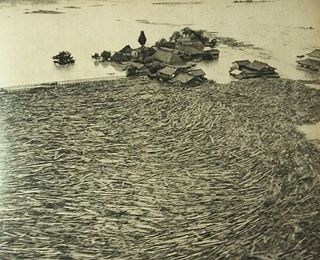
The 1953 North Kyushu flood was a flood which hit Northern Kyushu, Japan in June 1953. The flood was caused by cloudbursts and prolonged rain from the Meiyu rain front which dropped 1,000 mm of rain over Mount Aso and Mount Hiko. This downpour resulted in the overflow of many of the surrounding rivers, such as the Chikugo River.
The Hanaguri Ide is a specially constructed 387-meter canal in Kikuyō, Kumamoto, Japan, which lets water flow into the downstream without depositing the mixed ash. The Aso area from which water flows is rich in such ash, volcanic in nature. This structure was credited to Katō Kiyomasa who had it constructed it in the early 1600s.

The Tsubawara Dam, also known as the Tsubakihara Dam, is a gravity dam on the Shō River about 5 km (3.1 mi) north of Shirakawa in Gifu Prefecture, Japan. It was constructed between 1952 and 1953. The dam has an associated 107 MW hydroelectric power station which was built in two parts. The first part of the power station was commissioned in 1954 and the second part of the power station was commissioned in 1975. Of the nine dams on the Shō River it is the seventh furthest downstream.

The Hatogaya Dam is a gravity dam on the Shō River about 2 km (1.2 mi) south of Shirakawa in Gifu Prefecture, Japan. It was constructed between 1954 and 1956. The dam has an associated 43 MW hydroelectric power station which was commissioned in 1956. Of the nine dams on the Shō River it is the eighth furthest downstream.

The Oshirakawa Dam is a rock-fill dam on the Oshirakawa River about 16 km (9.9 mi) southwest of Shirakawa in Gifu Prefecture, Japan. It was constructed between 1961 and 1963. The dam has an associated 66.3 MW hydroelectric power station located about 7.1 km (4.4 mi) downstream which was commissioned in 1963.
Shirakawa Dam is an earth-fill dam located in Nara prefecture in Japan. The dam is used for agriculture. The catchment area of the dam is 6 km2. The dam impounds about 15 ha of land when full and can store 1360 thousand cubic meters of water. The construction of the dam was started in 1971 and completed in 1996.
References
- ↑ "Shirakawa Dam - Dams in Japan" . Retrieved 2022-02-22.
- ↑ Ogoshi, Haruyuki; Oashi, Naoto (1981). Grouting at the soft rock foundation of Shirakawa Dam. ISRM International Symposium. OnePetro.