The Casselman River is a 56.5-mile-long (90.9 km) tributary of the Youghiogheny River in western Maryland and Pennsylvania in the United States. The Casselman River drains an area of 576 square miles.

Chartiers Creek is a tributary of the Ohio River in Western Pennsylvania in the United States. The creek was named after Peter Chartier, a trapper of French and Native American parentage who established a trading post at the mouth of the creek in 1743.

Chartiers Run is a tributary of Chartiers Creek in Washington County, Pennsylvania in the United States. It was named after Peter Chartier, a trapper of French and Native American parentage who established a trading post at the mouth of Chartiers Creek in 1743.
Saw Mill Run is a tributary of the Ohio River in Pennsylvania. It is an urban stream, and lies entirely within Allegheny County, Pennsylvania. The stream enters the Ohio just downstream from the Forks of the Ohio in Pittsburgh, at a place that was founded as the town of Temperanceville in the 1830s. It provides an entry through the elevated plateau south of Pittsburgh known as the South Hills, and land transportation has paralleled the stream since the nineteenth century.

White Thunder Creek is a stream in the U.S. state of South Dakota.

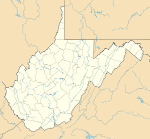
Girty Run is a stream in the U.S. state of West Virginia.
Buffalo Creek is a stream in the U.S. states of Pennsylvania and West Virginia. It rises in East Finley Township, Washington County, Pennsylvania. Its tributaries are Brushy Run, Mill Run, Indian Camp Run, Buck Run, and Dutch Fork. These streams flow through the townships of East Findley, Donegal, Hopewell, and Buffalo, and the creek itself empties into the Ohio River at Wellsburg, West Virginia.
Tebolt Run is a 3.46 mi (5.57 km) long 2nd order tributary to Big Sandy Creek in Fayette County, Pennsylvania. This is the only stream of this name in the United States.
West Branch Caldwell Creek is a 8.80 mi (14.16 km) long 2nd order tributary to Caldwell Creek in Warren County, Pennsylvania. It is the only stream of this name in the United States.
Dunderdale Creek is a 2.75 mi (4.43 km) long 1st order tributary to Caldwell Creek in Warren County, Pennsylvania. It is the only stream of this name in the United States.
Conneauttee Creek is a 13.26 mi (21.34 km) long 4th order tributary to French Creek in Crawford County, Pennsylvania. This is the only stream of this name in the United States.
Little Conneauttee Creek is a 14.27 mi (22.97 km) long 3rd order tributary to Conneauttee Creek in Crawford County, Pennsylvania and Erie County, Pennsylvania. This is the only stream of this name in the United States.
Darrows Creek is a 4.80 mi (7.72 km) long 3rd order tributary to Conneauttee Creek in Erie County, Pennsylvania. This is the only stream of this name in the United States.
West Branch Cussewago Creek is a 5.55 mi (8.93 km) long 2nd order tributary to Cussewago Creek in Crawford and Erie Counties, Pennsylvania. This is the only stream of this name in the United States.

Potecasi Creek is a 41.28 mi (66.43 km) long 4th order tributary to the Meherrin River in Hertford County, North Carolina. This is the only stream of this name in the United States.

Baker Mill Branch is a 3.53 mi (5.68 km) long 2nd order tributary to Deep Creek in Sussex County, Delaware. This is the only stream of this name in the United States.
Shorts Ditch is a 2.14 mi (3.44 km) long 1st order tributary to Deep Creek in Sussex County, Delaware. This is the only stream of this name in the United States.
Rum Bridge Branch is a 2.63 mi (4.23 km) long 2nd order tributary to Deep Creek in Sussex County, Delaware. This is the only stream of this name in the United States.
McColleys Branch is a 4.28 mi (6.89 km) long 2nd order tributary to Deep Creek in Sussex County, Delaware. This is the only stream of this name in the United States.

Crutchfield Branch is a 2.16 mi (3.48 km) long 4th order tributary to Mayo Creek in Halifax County, Virginia.