
Staraya Ladoga ; Finnish: Vanha Laatokka; Old Norse: Aldeigjuborg) is a rural locality in Volkhovsky District of Leningrad Oblast, Russia, located on the Volkhov River near Lake Ladoga, 8 kilometers (5.0 mi) north of the town of Volkhov, the administrative center of the district.

Solnechnogorsk is a town and the administrative center of Solnechnogorsky District in Moscow Oblast, Russia, located on the Moscow–St. Petersburg Highway and the Moscow–St. Petersburg railway, on the coast of Senezh Lake, 65 kilometers (40 mi) northwest from Moscow. Population: 52,944 (2010 Census); 58,374 (2002 Census); 55,554 (1989 Census).

Valday is a town and the administrative center of Valdaysky District in Novgorod Oblast, Russia, located on the southwestern shore of Lake Valdayskoye, the biggest one in the set of lakes in the highest region of the Valdai Hills, on the M10 Highway connecting Moscow and St. Petersburg, 386 kilometers (240 mi) from Moscow and 140 kilometers (87 mi) from Veliky Novgorod, the administrative center of the oblast. Population: 16,098 (2010 Census); 18,703 (2002 Census); 19,173 (1989 Census).
Demyansk is an urban locality and the administrative center of Demyansky District of Novgorod Oblast, Russia, located along the Yavon River. Municipally, it is incorporated as Demyanskoye Urban Settlement, the only urban settlement in the district. Population: 5,365 (2010 Census); 5,825 (2002 Census); 5,999 (1989 Census).

Pavlovo, also known as Pavlovo-na-Oke, is a town and the administrative center of Pavlovsky District in Nizhny Novgorod Oblast, Russia, located on the right bank of Oka River in the northwestern part of the Volga Upland. As of the 2010 Census, its population was 60,698.
Chudovo is a town and the administrative center of Chudovsky District in Novgorod Oblast, Russia, located on the Kerest River. Population: 15,397 (2010 Census); 17,434 (2002 Census); 17,982 (1989 Census).

Pestovo is a town and the administrative center of Pestovsky District in Novgorod Oblast, Russia, located in the Valdai Hills on the Mologa River. Population: 15,903 (2010 Census); 15,990 (2002 Census); 15,941 (1989 Census).

Shimsk is an urban locality and the administrative center of Shimsky District of Novgorod Oblast, Russia. Municipally, it is incorporated as Shimskoye Urban Settlement, the only urban settlement in the district. It is located on a highway connecting Veliky Novgorod and Pskov, 48 kilometers (30 mi) southwest of Veliky Novgorod. Shimsk lies on Shelon River, approximately 10 kilometers (6.2 mi) upstream from the point where it drains into Lake Ilmen. Population: 3,895 (2010 Census); 3,842 (2002 Census); 3,992 (1989 Census).

Kesova Gora is an urban locality and the administrative center of Kesovogorsky District of Tver Oblast, Russia, located 32 kilometers (20 mi) from Kashin and 50 kilometers (31 mi) from Bezhetsk. Population: 3,877 (2010 Census); 4,076 (2002 Census); 4,208 (1989 Census).

Uglovka is an urban locality in Okulovsky District of Novgorod Oblast, Russia, located on the Moscow – Saint Petersburg Railway. Municipally, it is incorporated as Uglovskoye Urban Settlement in Okulovsky Municipal District, one of the three urban settlements in the district. Population: 3,064 (2010 Census); 3,553 (2002 Census); 4,041 (1989 Census).

Navashino is a town in Nizhny Novgorod Oblast, Russia, located on a branch of the Oka River, 10km east of Murom and 158 kilometers (98 mi) southwest of Nizhny Novgorod. As of the 2010 Census, its population was 16,416.

Perevoz is a town and the administrative center of Perevozsky District in Nizhny Novgorod Oblast, Russia, located on the Pyana River, 120 kilometers (75 mi) southeast of Nizhny Novgorod, the administrative center of the oblast. Population: 9,201 (2010 Census); 9,386 (2002 Census); 8,313 (1989 Census).

Batetsky District is an administrative and municipal district (raion), one of the twenty-one in Novgorod Oblast, Russia. It is located in the northwest of the oblast and borders with Luzhsky District of Leningrad Oblast in the northwest, Novgorodsky District in the east, and with Shimsky District in the south. The area of the district is 1,600 square kilometers (620 sq mi). Its administrative center is the rural locality of Batetsky. District's population: 6,335 (2010 Census); 6,996 ; 7,622 (1989 Census). The population of the administrative center accounts for 35.6% of the district's total population.

Demyansky District is an administrative and municipal district (raion), one of the twenty-one in Novgorod Oblast, Russia. It is located in the south of the oblast and borders with Krestetsky District in the north, Valdaysky District in the northeast, Firovsky District of Tver Oblast in the southeast, Ostashkovsky District of Tver Oblast in the south, Maryovsky District in the southwest, Starorussky District in the west, and with Parfinsky District in the northwest. The area of the district is 3,200 square kilometers (1,200 sq mi). Its administrative center is the urban locality of Demyansk. Population: 13,001 (2010 Census); 16,020 ; 18,488 (1989 Census). The population of Demyansk accounts for 41.3% of the district's total population.
Krestetsky District is an administrative and municipal district (raion), one of the twenty-one in Novgorod Oblast, Russia. It is located in the center of the oblast and borders with Malovishersky District in the north, Okulovsky District in the northeast, Valdaysky District in the southeast, Demyansky District in the south, Parfinsky District in the southwest, and with Novgorodsky District in the northwest. The area of the district is 2,790.63 square kilometers (1,077.47 sq mi). Its administrative center is the urban locality of Kresttsy. Population: 12,940 (2010 Census); 15,667 ; 16,957 (1989 Census). The population of Kresttsy accounts for 67.4% of the district's total population.

Maryovsky District is an administrative and municipal district (raion), one of the twenty-one in Novgorod Oblast, Russia. It is located in the south of the oblast and borders with Demyansky District in the north, Ostashkovsky and Penovsky Districts of Tver Oblast in the southeast, Andreapolsky District of Tver Oblast and Kholmsky District in the southwest, Poddorsky District in the west, and with Starorussky District in the northwest. The area of the district is 1,800 square kilometers (690 sq mi). Its administrative center is the rural locality of Maryovo. District's population: 4,673 (2010 Census); 5,711 ; 6,835 (1989 Census). The population of Maryovo accounts for 49.2% of the district's total population.
Pestovsky District is an administrative and municipal district (raion), one of the twenty-one in Novgorod Oblast, Russia. It is located in the east of the oblast and borders with Chagodoshchensky District of Vologda Oblast in the north, Ustyuzhensky District of Vologda Oblast in the northeast, Sandovsky District of Tver Oblast in the southeast, Lesnoy District of Tver Oblast in the south, Moshenskoy District in the west, and with Khvoyninsky District in the northwest. The area of the district is 2,120 square kilometers (820 sq mi). Its administrative center is the town of Pestovo. Population: 21,676 (2010 Census); 23,931 ; 25,331 (1989 Census). The population of Pestovo accounts for 73.4% of the district's total population.

Valdaysky District is an administrative and municipal district (raion), one of the twenty-one in Novgorod Oblast, Russia. It is located in the southeast of the oblast and borders with Okulovsky District in the north, Bologovsky District of Tver Oblast in the east, the territory of the closed administrative-territorial formation of Ozyorny of Tver Oblast in the southeast, Firovsky District of Tver Oblast in the south, Demyansky District in the southwest, and with Krestetsky District in the northwest. The area of the district is 2,701.63 square kilometers (1,043.11 sq mi). Its administrative center is the town of Valday. Population: 26,476 (2010 Census); 29,943 ; 32,373 (1989 Census). The population of Valday accounts for 60.8% of the district's total population.
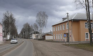
Maryovo is a rural locality and the administrative center of Maryovsky District of Novgorod Oblast, Russia, located in the south of the oblast, on the Maryovka River, a tributary of the Pola River. Municipally, it is the administrative center of Maryovskoye Rural Settlement. Population: 2,297 (2010 Census); 2,631 (2002 Census); 2,797 (1989 Census).
Poddorye is a rural locality and the administrative center of Poddorsky District of Novgorod Oblast, Russia, located in the southwest of the oblast, on the Redya River, a left tributary of the Lovat River. Municipally, it is the administrative center of Poddorskoye Rural Settlement. Population: 1,860 (2010 Census); 1,957 (2002 Census); 2,122 (1989 Census).

