
A ruby is a pink-ish red to blood-red colored gemstone, a variety of the mineral corundum. Ruby is one of the most popular traditional jewelry gems and is very durable. Other varieties of gem-quality corundum are called sapphires. Ruby is one of the traditional cardinal gems, alongside amethyst, sapphire, emerald, and diamond. The word ruby comes from ruber, Latin for red. The color of a ruby is due to the element chromium.
The Lisu people are a Tibeto-Burman ethnic group who inhabit mountainous regions of Myanmar (Burma), southwest China, Thailand, and the Indian state of Arunachal Pradesh.

The 10th Princess Mary's Own Gurkha Rifles,, was originally a rifle regiment of the British Indian Army. The regiment was first formed in 1890, taking its lineage from a police unit and over the course of its existence it had a number of changes in designation and composition. It took part in a number of campaigns on the Indian frontiers during the 19th and early 20th centuries, before fighting in the First World War, the Third Anglo-Afghan War and the Second World War. Following India's independence in 1947, the regiment was one of four Gurkha regiments to be transferred to the British Army. In the 1960s it was active in the Malayan Emergency and Indonesian Confrontation. It was amalgamated with the other three British Gurkha regiments to form the Royal Gurkha Rifles in 1994.
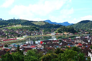
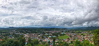
Mogok is a city in the Pyin Oo Lwin District of Mandalay Division of Myanmar, located 200 kilometres (120 mi) north of Mandalay and 148 kilometres (92 mi) north-east of Shwebo.
The Southern Asia Division (SUD) of Seventh-day Adventists is headquartered at Hosur, Tamil Nadu, India. It heads the activities of the Seventh-day Adventist Churches and its affiliated bodies in India, Nepal and Bhutan.The Division has 1,607,719 members as of June 30, 2018.

Myinmu is a river town in the south-east of the Sagaing Division in Burma. The town has a rich history linked to World War II during the Burma Campaign against the Japanese, in 1944. It was also under the control of the Portuguese Missionaries in the 19th century. One of the first agricultural cooperatives was established here in 1905.

Mong Hsu Township is a township of Loilen District in the Shan State of Myanmar. The principal town is Mong Hsu. Om-pu waterfall on Nam Parng River of Mong Hsu is the second largest waterfall of Shan State. The nearest commercial airport to Mong Hsu is Lashio Airport.

Momeik, also known as Mong Mit in Shan, is a town situated on the Shweli River in northern Shan State of Myanmar (Burma).

The Third Anglo-Burmese War, also known as the Third Burma War, was a conflict that took place during 7–29 November 1885, with sporadic resistance and insurgency continuing into 1887. It was the final of three wars fought in the 19th century between the Burmese and the British. The war saw the loss of sovereignty of an independent Burma under the Konbaung dynasty, whose rule had already been reduced to the territory known as Upper Burma, the region of Lower Burma having been annexed by the British in 1853, as a result of the Second Anglo-Burmese War.

Burmese Gurkhas are a group of Nepali language speaking Burmese people of Gurkha ethnic group living in Myanmar. While the Gurkhas have lived in Burma for many centuries, it was during the British rule in Burma that the majority of the Gurkha migrated from Nepal.

Myinmu Township is a township in the southeast of the Sagaing Division in Burma (Myanmar), west of Mandalay. The principal town is Myinmu which lies on the northern bank of the Irrawaddy River. History of Myinmu is closely linked to the World War II against the Japanese Army when British General Sir Douglas Gracey occupied the town after crossing the Irrawaddy River.
Mankat is a large village in Banmauk Township, Katha District, in the Sagaing Region of northern-central Burma. The area is known for its Mankat Forest reserve.
Kutkai is a town and seat of Kutkai Township, in the Shan State of eastern-central Burma. It lies along National Highway 3, approximately 24 kilometres to the north of Lashio.
Yegyibauk is a river village on the Myitnge River in Amarapura Township, Mandalay District, in the Mandalay Region of central Burma. It is located just to the southwest of Myitnge. The village was mentioned in the Agricultural Journal of India by the Indian Council of Agricultural Research in 1914.
Gwebin is a village in Mogok Township, Pyin Oo Lwin District, in the Mandalay Region of central Burma. It is located 16 miles (26 km) west of Mogok. A track connects it to Shwenyaungbin and Mogok.
Yenatha or Yentha is a village in Madaya Township, Pyin Oo Lwin District, in the Mandalay Region of central Burma. It is located 7 miles northeast of Madaya, connected by the National Highway 31. The Japanese were reported to have "put up pockets of resistance" at Yenatha during World War II. The Madaya River flows nearby to the south and joins the Irrawaddy River as well as the Yenatha Canal as part of the Mandalay Canal network. The Yenatha Irrigation Scheme has been funded by the Asian Development Bank, who recognizes the importance and potential of agriculture and fisheries in the area. The canal involves a pump irrigation scheme and cost some 9,900,000 kyat to build. A Leprosy hospital lies to the south of Yenatha.
Hsohsa is a village in Hsi Hseng Township, Taunggyi District, in the Shan State of eastern Burma. It is located northeast of the town of Loisawn. It is a primary agricultural village, with extensive fields around it. The village is named after Hso Hsa Hpa, a ruler of ancient Shan who was the son of Sao Pet Law.
Langkho, Laangkher, or Linkhay is a town and seat of Langkho Township and Langkho District, in the Shan State of eastern Burma. It is located east of Wān Long. It is served by Langhko Airport and is accessed along the National Road 45. A bridge in the vicinity crossing the Nam Teng River the town lies on is called Nam Kok Bridge. This town is famous for being the song "Langkho A Win", written by Sai Htee Saing.
Panlong Subtownship is a subtownship of the Wa Self-Administered Division of Shan State, formerly and conterminously part of Hopang District.

Mongmit or Möngmit, also known as Momeik, was a Shan state in the Northern Shan States in what is today Burma. The capital was Mongmit town. The state included the townships of Mongmit and Kodaung.
