| Sian Ka'an | |
|---|---|
IUCN category Ia (strict nature reserve) | |
 Sian Ka'an | |
 Location in Mexico | |
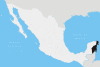
| Location | Tulum, Quintana Roo, Mexico |
| Coordinates | 19°30′N87°45′W / 19.5°N 87.75°W Coordinates: 19°30′N87°45′W / 19.5°N 87.75°W |
| Area | 2,797 km2 (1,080 sq mi) [1] |
| Established | 1986 |
| Type | Natural |
| Criteria | vii, x |
| Designated | 1987 (11th session) |
| Reference no. | 410 |
| State Party | Mexico |
| Region | Latin America and the Caribbean |
| Designated | 27 November 2003 |
| Reference no. | 1329 [2] |
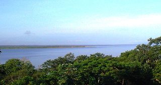
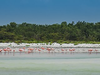
Sian Ka'an is a biosphere reserve in the municipality of Tulum in the Mexican state of Quintana Roo. It was established in 1986 and became a UNESCO World Heritage Site in 1987. [3]

Quintana Roo, officially the Free and Sovereign State of Quintana Roo, is one of the 31 states which, with the Federal District, make up the 32 federal entities of Mexico. It is divided into 11 municipalities and its capital city is Chetumal.

The United Nations Educational, Scientific and Cultural Organization is a specialized agency of the United Nations (UN) based in Paris. Its declared purpose is to contribute to peace and security by promoting international collaboration in education, sciences, and culture in order to increase universal respect for justice, the rule of law, and human rights along with fundamental freedom proclaimed in the United Nations Charter. It is the successor of the League of Nations' International Committee on Intellectual Cooperation.
A World Heritage Site is a landmark or area which is selected by the United Nations Educational, Scientific and Cultural Organization (UNESCO) as having cultural, historical, scientific or other form of significance, and is legally protected by international treaties. The sites are judged important to the collective interests of humanity.
Contents
With the participation of scientists, technicians, students, fishermen, farmers, rural promotors and administrators, together with regional and international partners, have successfully carried out more than 200 conservation projects basing all conservation actions on scientific and technical information for planning and implementing environmental policies and the proposal of viable solutions for sustainable use of natural resources and focusing their efforts established within eight protected natural areas that include the reefs of Banco Chinchorro, and Xcalak at South of Quintana Roo, Sian Ka'an Biosphere Reserve, Cancun, the island of Cozumel that is located in front of Xcaret and Contoy Island up North, covering 780,000 acres (3,200 km2). These areas lie in parts of all seven Caribbean Sea coastal municipalities of the state, with the largest part being in eastern Felipe Carrillo Puerto Municipality, where the vast majority of Sian Ka'an Biosphere Reserve lies.

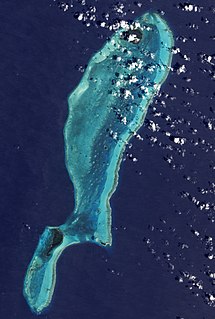
Banco Chinchorro is an atoll reef lying off the southeast coast of the Municipality of Othón P. Blanco in Quintana Roo, Mexico, near Belize. It was featured throughout the 2009 semi-documentary film Alamar by Pedro González-Rubio.
Xcalak is a village of 375 inhabitants in the municipality of Othón P. Blanco, Quintana Roo, on the Caribbean coast of Mexico. It is one of the last "unspoiled" stretches of Mexican Caribbean located on the southern end of the Costa Maya. The world's second largest barrier reef passes just off-shore from Xcalak and it is also a departure point for dive trips to the Chinchorro Banks atoll reef system. It is designated a Mexican national reef park and is an excellent site for snorkeling, scuba diving and fly fishing. It is 60 kilometers (37 mi) south of Mahahual, the site of a new large cruise ship pier, and just north of the border with Belize. The Mahahual pier was destroyed by hurricane Dean in 2007. This section of coast is now being developed by the tourism industry and has a growing number of Americans and other expatriates investing in beach front property north of town. However, development is nowhere close to the degree of development of its Northern cities Cancún and Playa del Carmen.

Cozumel is an island and municipality in the Caribbean Sea off the eastern coast of Mexico's Yucatán Peninsula, opposite Playa del Carmen. It is separated from mainland by Cozumel Channel and is close to the Yucatán Channel. The municipality is part of the state of Quintana Roo, Mexico.
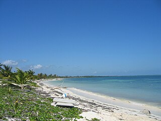
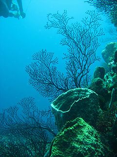
Part of the reserve is on land and part is in the Caribbean Sea, including a section of coral reef. The reserve has an area of 5,280 km2. [4]
The Caribbean Sea is a sea of the Atlantic Ocean in the tropics of the Western Hemisphere. It is bounded by Mexico and Central America to the west and south west, to the north by the Greater Antilles starting with Cuba, to the east by the Lesser Antilles, and to the south by the north coast of South America.

A coral reef is an underwater ecosystem characterized by reef-building corals. Reefs are formed of colonies of coral polyps held together by calcium carbonate. Most coral reefs are built from stony corals, whose polyps cluster in groups.
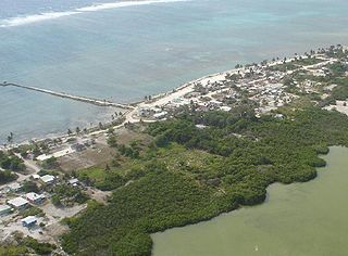
The reserve also includes some 23 known archaeological sites of the Maya civilization [3] including Muyil. Remains of the Decauville railway Vigía Chico-Santa Cruz, which was operated from 1905 to 1932, can be found at several places.

The Maya civilization was a Mesoamerican civilization developed by the Maya peoples, and noted for its logosyllabic script—the most sophisticated and highly developed writing system in pre-Columbian Americas—as well as for its art, architecture, mathematics, calendar, and astronomical system. The Maya civilization developed in an area that encompasses southeastern Mexico, all of Guatemala and Belize, and the western portions of Honduras and El Salvador. This region consists of the northern lowlands encompassing the Yucatán Peninsula, and the highlands of the Sierra Madre, running from the Mexican state of Chiapas, across southern Guatemala and onwards into El Salvador, and the southern lowlands of the Pacific littoral plain.

Muyil was one of the earliest and longest inhabited ancient Maya sites on the eastern coast of the Yucatan Peninsula. It is located approximately 15 kilometres (9.3 mi) south of the coastal site of Tulum, in the Municipality of Felipe Carrillo Puerto in the state of Quintana Roo, Mexico. Artifacts found here date back from as early as 350 BC. to as late as 1200-1500 AD. The ruins of Muyil are an example of Peten architecture, like those found in southern Mayan sites with their steep walled pyramids such as Tikal in Guatemala. It is situated on the Sian Ka'an lagoon, a name meaning "Where the Sky is Born". Muyil was located along a trade route on the Caribbean once accessible via a series of canals. Among the most commonly traded goods were Jade, obsidian, chocolate, honey, feathers, chewing gum, and salt. It is believed that throughout much of its history, Muyil had strong ties to the center of Coba located some 44 kilometres (27 mi) the north / northwest. The 2010 federal census reported a population of 191 inhabitants in the locality.

The Decauville railway Vigía Chico-Santa Cruz was a nearly 57 km (35 mi) long 600 mm gauge railway line, which was built during the Caste War of Yucatán at Santa Cruz in Mexico and operated from 1905 to 1932.
Within the Amigos de Sian Ka'an project objectives are the identification, protection and management of additional areas with high biodiversity value as well as those critical for maintenance of the life cycles of endangered, threatened and migratory species in the Riviera Maya and providing environmental education through books, journals and pamphlets and giving technical assistance and training to Mayan communities working with ecotourism.
Biodiversity refers to the variety and variability of life on Earth. Biodiversity is typically a measure of variation at the genetic, species, and ecosystem level. Terrestrial biodiversity is usually greater near the equator, which is the result of the warm climate and high primary productivity. Biodiversity is not distributed evenly on Earth, and is richest in the tropics. These tropical forest ecosystems cover less than 10 percent of earth's surface, and contain about 90 percent of the world's species. Marine biodiversity is usually highest along coasts in the Western Pacific, where sea surface temperature is highest, and in the mid-latitudinal band in all oceans. There are latitudinal gradients in species diversity. Biodiversity generally tends to cluster in hotspots, and has been increasing through time, but will be likely to slow in the future.

The Riviera Maya is a tourism and resort district south of Cancun, Mexico. It straddles the coastal Federal Highway 307, along the Caribbean coastline of the state of Quintana Roo, located in the eastern portion of the Yucatán Peninsula. Historically, this district started at the city of Playa del Carmen and ended at the village of Tulum, although the towns of Puerto Morelos, situated to the north of Playa del Carmen, as well as the town of Felipe Carrillo Puerto, situated 40 kilometres (25 mi) to the south of Tulum, are both currently being promoted as part of the Riviera Maya tourist corridor.