Related Research Articles
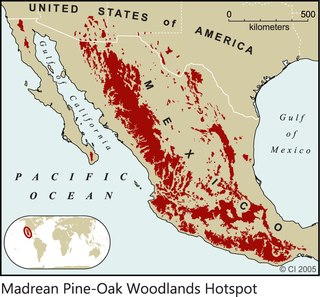
The Madrean pine–oak woodlands are subtropical woodlands found in the mountains of Mexico and the southwestern United States. They are a biogeographic region of the tropical and subtropical coniferous forests and temperate broadleaf and mixed forests biomes, located in North America.

The Madrean Sky Islands are enclaves of Madrean pine–oak woodlands, found at higher elevations in a complex of small mountain ranges in southern and southeastern Arizona, southwestern New Mexico, and northwestern Mexico. The sky islands are surrounded at lower elevations by the Sonoran and Chihuahuan deserts. The northern west–east perimeter of the sky island region merges into the higher elevation eastern Mogollon Rim and the White Mountains of eastern Arizona.

The Santa Cruz River is a tributary river to the Gila River in Southern Arizona and northern Sonora, Mexico. It is approximately 184 miles (296 km) long.

Alnus oblongifolia is a large alder, birch-family tree up to 72 feet (22 m), from the southwestern United States and northern Sonora, Mexico. It grows across Arizona into western New Mexico mountain ranges. In central Arizona its range extends across the transition zone to the White Mountains region of eastern Arizona–western New Mexico border.

The Altar Valley is a 45-mile (72 km) long north-south valley, trending slightly northeast from Sasabe, Arizona on the Mexico border to the Avra Valley west of the Tucson Mountains. It is delimited by Arizona State Route 86, from east-to-west on the north separating it from the Avra Valley which then trends northwesterly, merging into the plains and drainage of the Santa Cruz River.
The Sierra San Luis range is a mountain range in northwest Chihuahua, northeast Sonora, Mexico at the northern region of the Sierra Madre Occidental cordillera. The region contains sky island mountain ranges, called the Madrean Sky Islands, some separated from the Sierra Madre Occidental proper, and occurring in the northeastern Sonoran Desert, and extreme west-northwestern Chihuahuan Desert. Many of the ranges occur in southeast Arizona.
Sierra del Tigre is a mountain range in northeastern Sonora, Mexico at the northern region of the Sierra Madre Occidental. The region contains sky island mountain ranges, called the Madrean Sky Islands, some separated from the Sierra Madre Occidental proper, and occurring in the northeastern Sonoran Desert, and extreme west-northwestern Chihuahuan Desert. Many of the ranges occur in southeast Arizona.

The Patagonia Mountains are a 15-mile-long (24 km) mountain range within the Coronado National Forest, and in Santa Cruz County, Arizona, United States.
The Sierra San Antonio is a mountain range in southernmost Arizona state (U.S.) and northern Sonora state (México).

Yucca × schottii is a plant species in the genus Yucca, native to southern Arizona, southwestern New Mexico, and the northern parts of Sonora and Chihuahua. The common names are Schott's yucca, hoary yucca, and mountain yucca. The "×" in the name indicates that this is a nothospecies, regarded as being a natural hybrid between two other species. In this case, Yucca × schottii is believed to have originated as a hybrid between Y. baccata and Y. madrensis. Yucca × schottii is firmly established and does reproduce freely in the wild.

Salix bonplandiana, , is a perennial species of willow tree native to southern and southwest Mexico and extending into central Guatemala; in western Mexico it is a tree of the Sierra Madre Occidental cordillera, but also occurring in other small locales, for example Baja California Sur, northern Sonora, San Luis Potosi, etc. A core disjunct area occurs in central and southeast Arizona, in advantageous locales, especially associated with higher elevations and water.
Eysenhardtia orthocarpa is a species of small flowering tree, in the legume family, Fabaceae. Its range is at the northern region of the Sierra Madre Occidental cordillera of eastern Sonora; it is also in central Sonora, with the species ranging into southeast Arizona and the extreme southwest, bootheel region of New Mexico, the entire sky island region at the northern cordillera called Madrean Sky Islands.
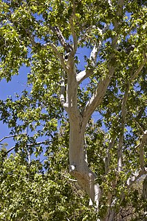
Platanus wrightii, the Arizona sycamore, is a sycamore tree native to Arizona and New Mexico with its range extending south into the Mexican states of Sonora, Chihuahua, and Sinaloa.

The Atascosa Mountains is a mountain range in western Santa Cruz County, Arizona, United States. It is sandwiched between the larger Tumacacori Mountains to the north, and a small east–west border range to the south, the Pajarito Mountains; the Pajaritos are on the U.S.–Mexico border and abut the Sierra La Esmeralda range in northern Sonora.

The San Luis Mountains are a small, lower elevation mountain range of central-southern Pima County Arizona adjacent to the U.S.-Mexico border, northeast of Sasabe, Arizona–Sasabe, Sonora.
The Pajarito Mountains is a small mountain range of western Santa Cruz County, Arizona, United States, that extend south into Sonora, Mexico. The range is adjacent the Atascosa Mountains at its north, with both ranges in the center of a north-south sequence of ranges called the Tumacacori Highlands. The Highlands have the Tumacacori Mountains at the north, and south of the U.S.-Mexico border, the Sierra La Esmeralda range. The Tumacacori Highlands are part of a regional conservancy study of "travel corridors" for cats, called Cuatro Gatos, Four Cats, for mountain lions, ocelot, bobcat, and jaguar.

The Tumacacori Mountains is a mountain range in Santa Cruz and Pima counties in southern Arizona, United States. The highest peak in the range is an unnamed summit with an elevation of 5,736 feet (1,748 m).
References
- Arizona Highways. Emerald Isle, Terry Greene Sterling, photography, Jack Dykinga, February, 2010, pp. 40–43.