
The Dominican Republic is a country in the West Indies that occupies the eastern five-eighths of Hispaniola. It has an area of 48,670 km2, including offshore islands. The land border shared with Haiti, which occupies the western three-eighths of the island, is 376 km long. The maximum length, east to west, is 390 km from Punta de Agua to Las Lajas, on the border with Haiti. The maximum width, north to south, is 265 km from Cape Isabela to Cape Beata. The capital, Santo Domingo, is located on the south coast.

Baoruco, alternatively spelt Bahoruco, is a province of the Dominican Republic located in the southwest of the country, part of the Enriquillo Region, along with the provinces of Barahona, Independencia and Pedernales. Before 1952 it included what is now Independencia Province.

Barahona is a province of the Dominican Republic. Located in the country's southwestern region, it is dividing into 11 municipalities and its capital bears the city of the same name. Barahona borders the provinces of Pedernales to the southwest, Baoruco and Independencia to the north, and Azua to the east along with coastline to the south with the Caribbean Sea. The province has an approximately three hours drive from Santo Domingo the capital of the Dominican Republic. In 2019, volunteers from Amigos de las Americas visited to facilitate projects within the various municipalities of Barahona.

Pedernales is the southernmost province of the Dominican Republic, including the offshore island of Isla Beata. It was split from Barahona in 1957. Of its 2,074.53 km2, 1,374 km2 belongs to the Jaragua National Park. A third of its population is of Haitian origin, the highest ratio within the country.

Pico Duarte is the highest peak in the Dominican Republic, on the island of Hispaniola and in all the Caribbean. At 3,101 m (10,174 ft) above sea level, it gives Hispaniola the 16th-highest maximum elevation of any island in the world. Additionally, it is only 85 kilometres northeast of the region's lowest point, Lake Enriquillo, 46 m below sea level. It is part of the Cordillera Central range, which extends from the plains between San Cristóbal and Baní to the northwestern peninsula of Haiti, where it is known as the Massif du Nord. The highest elevations of the Cordillera Central are found in the Pico Duarte and Valle Nuevo massifs.
Lake Enriquillo is a hypersaline lake in the Dominican Republic located in the southwestern region of the country. Its waters are shared between the provinces of Bahoruco and Independencia, the latter of which borders Haiti. Lake Enriquillo is the largest lake in both the Dominican Republic and Hispaniola, as well as the entire Caribbean. It is also the lowest point for an island country.

Enriquillo, also known as "Enrique" by the Spaniards, was a Taíno cacique who rebelled against the Spaniards between 1519 and 1533. Enriquillo's rebellion is the best known rebellion of the early Caribbean period. He was born on the shores of Lake Jaragua and was part of the royal family of Jaragua. Enriquillo's aunt Anacaona was Queen of Jaragua, and his father Magiocatex was the crown prince. He is considered a hero in the modern day Dominican Republic for his resistance in favor of the indigenous peoples. Dominican friar Bartolomé de las Casas, who documented and rallied against Spanish abuse of the native peoples, wrote sympathetically of Enriquillo.
Neiba is a city in the southwest of the Dominican Republic. It is the capital city of the Baoruco province, and is located 180 kilometres west of the national capital, Santo Domingo, close to the shore of Lake Enriquillo, the largest lake in the West Indies.
Jaragua National Park is a Dominican national park located in Pedernales Province, in the extreme southwest of the Dominican Republic. Jaragua has a total area of 1,374 km², the largest such protected area in the Caribbean.

The Hispaniolan hutia is a small, threatened, rat-like mammal endemic to forests on the Caribbean island of Hispaniola. It lives in burrows or trees, and is active at night when it feeds on roots and fruits. A member of the hutia subfamily (Capromyinae), it is endangered from habitat loss and introduced species, such as rats or feral dogs.

The Bahoruco Mountain Range—Sierra de Bahoruco is a mountain range located in the far southwestern region of the Dominican Republic. It is within Pedernales, Independencia, Barahona, and Bahoruco Provinces. A large part of the area is protected within the Sierra de Bahoruco National Park, also a Biosphere reserve.

The Hispaniolan parrot, also known as Hispaniolan amazon, is a species of psittaciform bird of the family Psittacidae endemic to Hispaniola, which includes the Dominican Republic and Haiti. Its white forehead, light beak, white eye-ring, blue ear patch, and maroon belly patch are the main features that differentiate it from other amazons. Its body measures about 28 centimeters in length. A typical adult weighs 250g (8.75 oz).

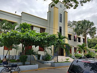
The Dominican city of Pedernales is the capital of the Pedernales Province, in the Dominican Republic. It is located in the southwest of the country, on the Dominican Republic–Haiti border, and has a crossing to the Haitian town of Anse-à-Pitres.

Lago de Oviedo, also known as Laguna de Oviedo, is a saltwater lake in Jaragua National Park, Pedernales Province, Dominican Republic.

Bahía de las Águilas, is an 8 km-long (5 mi) beach along the southwestern coast of the Dominican Republic in the province of Pedernales near the southernmost part of the border with Haiti. The bay is part of the Jaragua National Park, and it is considered by many Dominicans as one of the most beautiful beaches in the world, in some writers' opinion. The bay is a protected area as is the surrounding park; hence there is an abundance of sea life a few steps off the beach within its waters.
Under UNESCO’s Man and the Biosphere Programme, there are 125 biosphere reserves recognized as part of the World Network of Biosphere Reserves in Latin America and the Caribbean. These are distributed across 21 countries in the region.

The Hispaniolan moist forests are a tropical moist broadleaf forest ecoregion on the island of Hispaniola. They cover 46,000 km2 (18,000 sq mi), around 60% of the island's area.
The Hispaniolan dry forests are a tropical dry broadleaf forest ecoregion on the island of Hispaniola. They cover 15,123 km2 (5,839 sq mi), around 20% of the island's area.

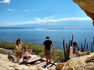
Cotubanamá National Park is located on the lower southeastern coast of the Dominican Republic, spanning across the provinces of La Altagracia and La Romana with an area of 791.9 sq. kilometers which includes a range of dense humid and dry subtropical forests, mangroves, beaches, and caves.

