Lødingen is a municipality in Nordland county in Norway. Lødingen is located on the southeastern corner of the island of Hinnøya, and is part of the traditional district of Ofoten. The administrative centre of the municipality is the village of Lødingen. The other main village is Vestbygda. Lødingen has the nickname "Biketown" because it hosts several annual bicycle races like Lofoten Insomnia and Vestbygd-rittet.

Hadsel is a municipality in Nordland county, Norway. It is part of the traditional district of Vesterålen. The administrative centre of the municipality is the town of Stokmarknes. Other villages in Hadsel include Fiskebøl, Gjerstad, Grønning, Grytting, Hanøyvika, Hennes, Kaljord, Melbu, Sanden, and Sandnes.
Bø is a municipality in Nordland county, Norway. It is part of the Vesterålen region. The administrative centre of the municipality is the village of Straume. Other villages in the municipality include Auvåg, the village of Bø, Eidet, Guvåg, Hovden, Klakksjorda, Malnes, Nykvåg, Utskor, and Vågen. The Litløy Lighthouse is located on the tiny island of Litløya off the coast of Bø.

Øksnes is a municipality in Nordland county, Norway. It is located on the northwestern part of the large island of Langøya, which is a part of the traditional region of Vesterålen. The administrative centre of the municipality is the village of Myre. Other villages in Øksnes include Alsvåg, Barkestad, Breidstrand, Nyksund, Strengelvåg, and Stø.

Andøy is the northernmost municipality in Nordland county, Norway. It is part of the Vesterålen archipelago. The main island in the municipality is Andøya. The administrative centre of the municipality is the village of Andenes. Other villages in the municipality include Bjørnskinn, Bleik, Dverberg, Fiskenes, Fornes, Nordmela, Risøyhamn, Skarstein, Å, Åknes, and Åse.

Hinnøya is the fourth largest island in Norway. The 2,204.7-square-kilometre (851.2 sq mi) lies just off the western coast of Northern Norway. The island sits on the border of Nordland and Troms counties. The western part of the island is in the district of Vesterålen, the southwestern part is in the Lofoten district, the southeastern part is in the Ofoten district, and the northeastern part is in Southern Troms.

Bjerka is a village in the municipality of Hemnes in Nordland county, Norway. It is located along the European route E06 highway and the Nordland Line, about 20 kilometres (12 mi) southeast of Hemnesberget and about 7 kilometres (4.3 mi) north of the municipal center of Korgen.

Straume is the administrative centre of Bø Municipality in Nordland county, Norway. The village is located on the island of Langøya in the Vesterålen archipelago. The village is located about 10 kilometres (6.2 mi) from the village of Bø and the village of Eidet, in the west central part of the municipality.
Reine is the administrative centre of Moskenes Municipality in Nordland county, Norway. The fishing village is located on the island of Moskenesøya in the Lofoten archipelago, above the Arctic Circle, about 300 kilometres (190 mi) southwest of the town of Tromsø. Reine Church is located here and it serves the northern part of the municipality.

Reipå is a village in the municipality of Meløy in Nordland county, Norway. It is located along Norwegian County Road 17 about 6 kilometres (3.7 mi) north of the village of Ørnes. The lakes Lysvatnet and Markavatnet both lie to the east of the village. Fore Church is located in Reipå, serving northern Meløy.

Straumsnes or Strømsnes is a village in the municipality of Fauske in Nordland county, Norway. It is located in the Valnesfjord area of Fauske. The town of Fauske lies 15 kilometres (9.3 mi) to the east and the town of Bodø lies about 40 kilometres (25 mi) to the west. The village sits just inland of Skjerstad Fjord, along the southern shore of the lake Valnesfjordvatnet.
Liland is a village in Sortland Municipality in Nordland county, Norway. The village is located on the island of Hinnøya along the Sortlandssundet strait, about 10 kilometres (6.2 mi) northeast of the town of Sortland, and just north of the Kvalsaukan Bridge.
Alsvåg is a village in the municipality of Øksnes in Nordland county, Norway. It is located on the western bank of the Gavlfjorden on the island of Langøya and about 8 kilometres (5.0 mi) east of the municipal centre of Myre. Alsvåg Church is located in this village.
Strand is a village in Sortland Municipality in Nordland county, Norway. The village is located on the island of Hinnøya at the eastern end of the Sortland Bridge which crosses the Sortlandsundet strait and connects to the town of Sortland on Langøya island. It is located about 5 kilometres (3.1 mi) north of the village of Sigerfjord.
Holand is a village in Sortland Municipality in Nordland county, Norway. The village is located on the island of Langøya along the Sortlandssundet strait, about 10 kilometres (6.2 mi) southwest of the town of Sortland and about 4 kilometres (2.5 mi) southwest of the village of Bø.
Bø is a village in Sortland Municipality in Nordland county, Norway. The village is located on the island of Langøya along the Sortlandssundet strait, about 6 kilometres (3.7 mi) southwest of the town of Sortland and about 4 kilometres (2.5 mi) northeast of the village of Holand.

Sigerfjord Church is a parish church of the Church of Norway in Sortland Municipality in Nordland county, Norway. It is located in the village of Sigerfjord on the island of Hinnøya. It is one of the three churches for the Sortland parish which is part of the Vesterålen prosti (deanery) in the Diocese of Sør-Hålogaland. The white, wooden church was built in a long church style in 1933 by the architect Harald Sund. The church seats about 280 people.
Holmstad is a village in Sortland Municipality in Nordland county, Norway. The village is located along the Eidsfjorden on the island of Langøya, about 12 kilometres (7.5 mi) west of the town of Sortland. Indre Eidsfjord Church is located in this village.

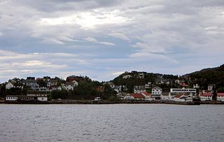
Sortland (help·info) is a town and the administrative centre of Sortland Municipality in Nordland county, Norway. The town is located on the east coast of the island of Langøya, along the Sortlandsundet strait. In 1997, the municipality decided to declare "town status" for the urban area of Sortland. Sortland is the largest town and commercial centre in the whole Vesterålen region and it is becoming known as "the blue town by the strait" since many of the buildings are painted blue.


