The Rio Grande in the United States or the Río Bravo in Mexico is one of the principal rivers in the southwestern United States and in northern Mexico. The length of the Rio Grande is 1,896 miles (3,051 km), making it the 4th longest river in the United States and in North America by main stem. It originates in south-central Colorado, in the United States, and flows to the Gulf of Mexico. The Rio Grande drainage basin (watershed) has an area of 182,200 square miles (472,000 km2); however, the endorheic basins that are adjacent to and within the greater drainage basin of the Rio Grande increase the total drainage-basin area to 336,000 square miles (870,000 km2).

The geography of Chile is extremely diverse, as the country extends from a latitude of 17° South to Cape Horn at 56° and from the Pacific Ocean at its west to the Andes at its east. Chile is situated in southern South America, bordering the South Pacific Ocean and a small part of the South Atlantic Ocean. Chile's territorial shape is considered among the world's most unusual; from north to south, the country extends 4,270 km (2,653 mi), and yet it only averages 177 km (110 mi) east to west. Chile reaches from the middle of South America's west coast straight down to the southern tip of the continent, where it curves slightly eastward. Diego Ramírez Islands and Cape Horn, the southernmost points in the Americas, where the Pacific and Atlantic oceans meet, are Chilean territory. Chile's northern neighbors are Peru and Bolivia, and its border with Argentina to the east, at 5,150 km (3,200 mi), is the world's third-longest. The total land size is 756,102 km2 (291,933 sq mi). The very long coastline of 6,435 km (3,999 mi) gives Chile the 11th largest exclusive economic zone of 3,648,532 km2 (1,408,706 sq mi).

The terms international waters or transboundary waters apply where any of the following types of bodies of water transcend international boundaries: oceans, large marine ecosystems, enclosed or semi-enclosed regional seas and estuaries, rivers, lakes, groundwater systems (aquifers), and wetlands.
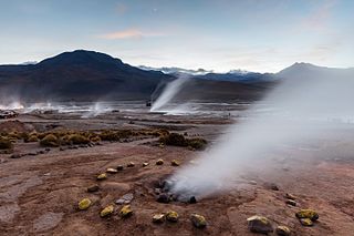
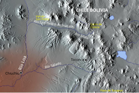
El Tatio is a geothermal field with many geysers located in the Andes Mountains of northern Chile at 4,320 metres (14,170 ft) above mean sea level. It is the third-largest geyser field in the world and the largest in the Southern Hemisphere. Various meanings have been proposed for the name "El Tatio", including "oven" or "grandfather". The geothermal field has many geysers, hot springs, and associated sinter deposits. These hot springs eventually form the Rio Salado, a major tributary of the Rio Loa, and are a major source of arsenic pollution in the river. The vents are sites of populations of extremophile microorganisms such as hyperthermophiles, and El Tatio has been studied as an analogue for the early Earth and possible past life on Mars.

Water resources law is the field of law dealing with the ownership, control, and use of water as a resource. It is most closely related to property law, and is distinct from laws governing water quality.

The Paraguay River is a major river in south-central South America, running through Brazil, Bolivia, Paraguay and Argentina. It flows about 2,695 kilometres (1,675 mi) from its headwaters in the Brazilian state of Mato Grosso to its confluence with the Paraná River north of Corrientes and Resistencia.
Water right in water law is the right of a user to use water from a water source, e.g., a river, stream, pond or source of groundwater. In areas with plentiful water and few users, such systems are generally not complicated or contentious. In other areas, especially arid areas where irrigation is practiced, such systems are often the source of conflict, both legal and physical. Some systems treat surface water and ground water in the same manner, while others use different principles for each.

The Biobío River is the second largest river in Chile. It originates from Icalma and Galletué lakes in the Andes and flows 380 km to the Gulf of Arauco on the Pacific Ocean.

The Loa River is a U-shaped river in Chile's northern Antofagasta Region. At 440 km (270 mi) long, it is the country's longest river and the main watercourse in the Atacama Desert.

Salar de Atacama, located 55 km (34 mi) south of San Pedro de Atacama, is the largest salt flat in Chile. It is surrounded by mountains and lacks drainage outlets. To the east, it is enclosed by the main chain of the Andes, while to the west lies a secondary mountain range called Cordillera de Domeyko. The landscape is dominated by imposing volcanoes such as Licancabur, Acamarachi, Aguas Calientes, and Láscar, the latter being one of Chile's most active volcanoes. These volcanoes are situated along the eastern side of the Salar de Atacama, forming a north–south trending line that separates it from smaller endorheic basins.
The Lauca River is a binational river. It originates in the Chilean Altiplano of the Arica and Parinacota Region, crosses the Andes and empties into Coipasa Lake in Bolivia.

The Maipo River is the main river flowing through the Santiago Metropolitan Region and the Valparaíso Region of Chile. It is located just south of the capital of Santiago. The Mapocho River, which flows through central Santiago, is one of its tributaries. Its headwaters are on the west slope of Maipo volcano, in the Andes. The Maipo River is by far the major source of irrigation and potable water for the region.

Water conflict typically refers to violence or disputes associated with access to, or control of, water resources, or the use of water or water systems as weapons or casualties of conflicts. The term water war is colloquially used in media for some disputes over water, and often is more limited to describing a conflict between countries, states, or groups over the rights to access water resources. The United Nations recognizes that water disputes result from opposing interests of water users, public or private. A wide range of water conflicts appear throughout history, though they are rarely traditional wars waged over water alone. Instead, water has long been a source of tension and one of the causes for conflicts. Water conflicts arise for several reasons, including territorial disputes, a fight for resources, and strategic advantage.
Water Resources Management (WRM) in Chile is widely known for its 1981 Water Code—written after General Augusto Pinochet took control through a military coup d'état. Free-market mechanisms became the economic philosophy in WRM, including the development of water markets and tradable water permits. A major reform to the 1981 Water Code was signed in 2005 to address social equity and environmental protection concerns. Water resources management in Chile is shared among the private sector which provides investment for infrastructure and distribution, and agencies provide regulatory oversight, maintain records, and issue water rights. Chile is negotiating formalized agreements with both Bolivia and Argentina to manage shared resources and water storage projects. Chile is also supported in rural water supply with $150 million in loans by the World Bank and the Inter-American Development Bank.
The Canal Lauca is an artificial channel to divert the waters of the Lauca River westward through a canal and tunnel into the Azapa Valley for purposes of irrigation in the valley and hydroelectric-power generation. Its construction began 1948 and water diversion began 14 years later from a dam located about 16 miles southwest of Lago Cotacotani Lake.
Gabriel E. Eckstein is an Israeli-born lawyer and professor at the Texas A&M University School of Law. His work focuses on water and environmental law and policy at the local, national, and international spheres. He is particularly known for his work addressing laws, regulations, and policies for managing transboundary freshwater resources, and especially the international law of transboundary groundwater resources. From 2017 until 2022, Eckstein represented the Plurinational State of Bolivia in its case against Chile in the Dispute over the Status and Use of the Waters of the Silala, and appeared before the International Court of Justice in April 2022.

The Bolivia–Chile border is an international border of South America. It separates Bolivia from Chile along Cordillera Occidental on the western edge of the Altiplano Plateau. There is an ongoing dispute about the nature of Silala River and Chile's use of its waters.

Dispute over the Status and Use of the Waters of the Silala is a case at the International Court of Justice. In the case, Chile petitioned the Court to declare the Silala River an "international watercourse whose use by Chile and Bolivia is governed by customary international law." Chile presented the case in 2016 while the Bolivian case against Chile, Obligation to Negotiate Access to the Pacific Ocean, was still ongoing. According to France 24 the case came as a surprise.
José Félix Mendieta Villarroel is a Bolivian politician and trade unionist who served as a member of the Chamber of Deputies from Cochabamba, representing circumscription 28 from 2010 to 2015.