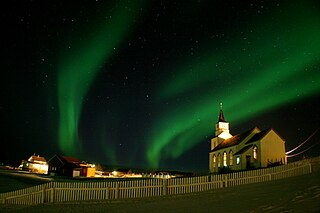
Sørreisa is a municipality in Troms county, Norway. The administrative centre of the municipality is the village of Sørreisa. Other villages include Grunnreisa, Skøelva, and Smørsgård.

Dyrøy is a municipality in Troms county, Norway. The administrative centre of the municipality is the village of Brøstadbotn. Other villages include Dyrøyhamn, Espenes, Holm, and Hundstrand.
Tranøy is a former municipality in Troms county, Norway. The municipality was situated on the southern coast of the large island of Senja. The municipality existed from 1838 until its dissolution in 2020 when it was merged into the new Senja Municipality. The administrative centre was the village of Vangsvik in the eastern part of the municipality. Other important villages included Stonglandseidet, Skrollsvika, and Å.

Torsken is a former municipality that was located on the western coast of the large island of Senja in Troms county, Norway. The municipality existed from 1902 until its dissolution in 2020 when it was merged into the new Senja Municipality. The administrative centre of the municipality was the village of Gryllefjord. Other larger villages in Torsken Municipality included the villages of Torsken, Medby, and Flakstadvåg.

Berg is a former municipality in Troms county, Norway. The municipality existed from 1838 until its dissolution in 2020 when it was merged into the new Senja Municipality. The administrative centre of the municipality was the village of Skaland. Other villages included Finnsæter, Mefjordvær, and Senjahopen. The municipality was located on the western part of the large island of Senja.

Lenvik is a former municipality in Troms county, Norway. The municipality existed from 1838 until its dissolution in 2020. The municipality was partly situated on the mainland and partly on the island of Senja in what is now Senja Municipality. The administrative centre was the town of Finnsnes, where the Gisund Bridge connects Senja to the mainland on Norwegian County Road 86. Other villages in the municipality included Aglapsvik, Gibostad, Botnhamn, Fjordgård, Finnfjordbotn, Husøy, Langnes, Laukhella, Silsand, and Rossfjordstraumen.

Senja (Norwegian) or Sážžá (Northern Sami) is an island in Senja Municipality in Troms county, Norway in northern Europe. With an area of 1,586.3 square kilometres (612.5 sq mi), it is the second largest island in Norway. It has a wild, mountainous outer (western) side facing the Atlantic, and a mild and lush inner (eastern) side. The island is located within Senja Municipality, which was established on 1 January 2020. The island of Senja had 7,864 inhabitants as of 1 January 2017. Most of the residents live along the eastern coast of the island, with Silsand being the largest urban area on the island. The fishing village of Gryllefjord on the west coast has a summer-only ferry connection to the nearby island of Andøya: the Andenes–Gryllefjord Ferry.
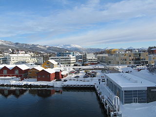
Finnsnes is a small town that is the administrative centre of Senja Municipality in Troms county, Norway. The town is located on the mainland part of Norway, just across the Gisundet strait from the island of Senja. The Gisund Bridge connects Finnsnes to the suburban villages of Silsand and Laukhella on the island of Senja. The municipality is well-provided with kindergartens and a decentralized school system on both primary and secondary levels. There are also three schools on the upper secondary/high school level and a center for decentralized studies at the university level. Finnsnes Church is located in the center of the town.
Vangsvik or Vangsvika is a village in Senja Municipality in Troms county, Norway. The village has a population of about 350. The village has a school, Vangsvik Chapel, store, and medical office. There is also a large fish farming facility nearby. The Senja Rutebil has its headquarters in Vangsvik. The village was the administrative centre of the old Tranøy Municipality until 1 January 2020 when it was merged into Senja Municipality.

Laukhella is a village in Senja Municipality in Troms county, Norway. The village lies to the west of the village of Silsand on the island of Senja. It is located along the Laksfjorden, about 5 km (3.1 mi) west of the town of Finnsnes.

Gryllefjord is a fishing village in Senja Municipality in Troms county, Norway. It is located on the island of Senja, along the Gryllefjorden in the northern part of the municipality. The 0.25-square-kilometre (62-acre) village has a population (2017) of 383 which gives the village a population density of 1,532 inhabitants per square kilometre (3,970/sq mi).
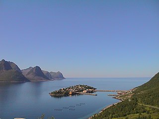
Senjahopen or Senjehopen is a village in Senja Municipality in Troms county, Norway. Senjahopen is located along the Mefjorden on the northwest part of the large island of Senja, where it is one of the most important fishing villages on the island. Another nearby fishing village is Mefjordvær, which located about 3 kilometres (1.9 mi) to the northwest.

Gibostad is a village on the large island of Senja in Senja Municipality in Troms county, Norway. Gibostad is a former trading centre, located about 20 km (12 mi) north of the Gisund Bridge. Many of the buildings in the harbour area are about 200 years old. The soil is very fertile and therefore suitable for farming, which is why Senja is also home to an agricultural school at Senja High School. The lake Lysvatnet is located just west of the village.
Husøy is a village in Senja Municipality in Troms county, Norway. The village covers the entire island of Husøy which is located in the Øyfjorden off the northwest coast of the large island of Senja. The village/island is located about 53 kilometres (33 mi) southwest of the city of Tromsø. The village of Fjordgård sits about 4 kilometres (2.5 mi) across the fjord on the island of Senja.
Sørkjosen is a village in Nordreisa Municipality in Troms county, Norway. The village is located along the shores of the Reisafjorden about 5 kilometres (3.1 mi) northwest of the municipal center of Storslett. Sørkjosen has many industries including fishing, dairy production, and a sawmill.
Hillesøy is a former municipality in Troms county in Norway. The 461-kilometre (286 mi) municipality existed from 1855 until its dissolution in 1964. It was located on both sides of the Malangen fjord in what is now Tromsø Municipality and Senja Municipality. The administrative centre was located at Brensholmen on the western shore of the island of Kvaløya. Brensholmen is also the location of Hillesøy Church, the main church for the municipality.

Torsken is a village in Senja Municipality in Troms county, Norway. It is located along the Torskenfjorden on the southwestern part of the island of Senja. The Skipsfjorden branches off the main fjord just east of the village. The historic Torsken Church is located in this village. There is one road into the village, from the municipal centre of Gryllefjord.

Skjervøy is the administrative centre in Skjervøy Municipality in Troms county, Norway. The town is located on the island of Skjervøya along the Kvænangen, near the mouth of the Reisafjorden. The 1.29-square-kilometre (320-acre) village has a population (2017) of 2,460 which gives the village a population density of 1,907 inhabitants per square kilometre (4,940/sq mi).
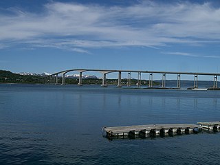
Gisundet is a strait in Senja Municipality in Troms county, Norway. The 35-kilometre (22 mi) long strait separates the island of Senja from the mainland. The strait flows into the Malangen fjord in the north and into the Finnfjorden in the south. The strait is crossed by the Gisund Bridge which connects the village of Silsand on the island to the town of Finnsnes on the mainland.
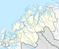
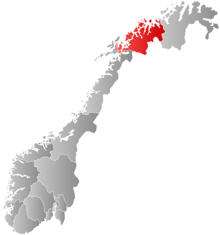
Senja is a municipality in Troms county, Norway. It was established on 1 January 2020 when the municipalities of Berg, Lenvik, Torsken, and Tranøy were merged into one municipality. It is located in the traditional district of Hålogaland. The administrative centre of the municipality is the town of Finnsnes. The municipality includes all of the island of Senja, the smaller surrounding islands, and part of the mainland between the Gisundet strait and the Malangen fjord.