
Medora is a village in Macoupin County, Illinois, United States. The population was 379 at the 2020 census, down from 419 in 2010.
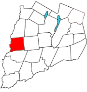
Pittsfield is a town in Otsego County, New York, United States. The population was 1,366 at the 2010 census.

Combined Locks is a village in Outagamie County, Wisconsin, United States. The population was 3,328 at the 2010 census.

Kimberly is a village in Outagamie County, Wisconsin, United States. The population was 7,320 at the 2020 census. The village is east of Appleton.

Stann Creek District is a district in the south east region of Belize. According to the 2010 census, the district had a population of 32,166 people. Its capital is the town of Dangriga, formerly known as "Stann Creek Town." Stann comes from "stanns," or safe havens used by colonialists coming from the "old world" to the "new world."

Toledo District is the southernmost and least populated district in Belize. Punta Gorda is the District capital. According to the Human Development Index (HDI), it is the second most developed region in the country. The district has a diverse topography which features rainforests, extensive cave networks, coastal lowland plains, and offshore cays. Toledo is home to a wide range of cultures such as Mopan, Kekchi Maya, Creole, Garifuna, East Indians, Mennonites, Mestizos, and descendants of US Confederate settlers.
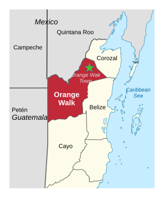
Orange Walk District is a district in the northwest of the nation of Belize, with its district capital in Orange Walk Town.

Nim Li Punit is a Maya Classic Period site in the Toledo District of the nation of Belize, located 50 kilometres north of the town of Punta Gorda, and directly adjacent to the village of Indian Creek. Nim Li Punit is sometimes known as Big Hat or Top Hat; the name is Kekchi Maya for "Big Hat", referring to the large elaborate head-dress on a stela sculpture found on site depicting one of the site's ancient kings. It is bordered by the Maya Mountains to the west and lowland swamps and the Caribbean Sea to the east.

San Pedro Columbia is a village in Toledo District, Belize, located about two miles from the ancient Maya ruins of Lubaantun. In 2000 San Pedro Columbia had a population of about 700 people. The population is mostly Q'eqchi Maya with some Mopan Maya. San Pedro Columbia has Belize's largest settlement of Kekchi. Most of the population came to Belize from the Petén region of Guatemala in the late 19th century. The village is known for the hand woven embroidery produced there.
Roaring Creek is a small village in the Cayo District of Belize, just north-west of Belmopan. Its name is derived from the creek waterfalls which flow into the Belize River next to the Guanacaste Park area.

Indian Church is a small remote village in the Orange Walk District of Belize. It is located on the west bank of New River, neighbouring the town of San Carlos to its south, and the Maya ruins of Lamanai to its north. According to the 2010 census, Indian Church has a population of 267 people in 66 households. The village is named for the historic Spanish churches recovered among the ancient Maya ruins. The residents lived among the ruins until 1991 when the Government of Belize established the 2-square-mile (5.2 km2) Lamanai Archaeological Reserve maintained by Belize's Institute of Archaeology.

Hopkins Village is a coastal village in eastern Belize.

Monkey River is a coastal watercourse in southern Belize that rises in the Maya Mountains and discharges to the Caribbean Sea near Monkey River Town. One of Belize's major rivers, Monkey River has northern headwaters which originate in the Cockscomb Basin Wildlife Sanctuary, where the Swasey Branch drains the East Basin of that wildlife sanctuary. Further south, the Bladen Branch watercourse drains the eastern slopes of the Maya Mountains including the ancient Mayan settlement areas of Lubaantun and Nim Li Punit. These two watercourses join to form the Monkey River approximately 16 kilometres upstream from the mouth of the Monkey River. The Monkey River is readily navigated throughout the year using small boats, but navigation above the major confluence becomes more difficult due to lack of depth when the dry season starts about February. Habitats in this watershed provide cover for such diverse species as the ocelot, jaguar, Guatemalan black howler, bare-throated tiger heron, Morelet's crocodile, fer-de-lance and manatee.
Xnaheb is an archaeological site of the pre-Columbian Maya civilization, one of five primary sites identified in the southern Belize region. The center is built on a ridge of foothills that extends from the Maya Mountains, in what is now the Toledo District of Belize. Based on certain architectural similarities between the two sites, it is possible that Xnaheb was founded as an offshoot of Nim Li Punit.
Gardenia is a village in Belize District, Belize located about 20 miles (32 km) north of Belize City.
Bomba is a settlement located in the nation of Belize. It is a mainland village located in Belize District. On November 1, 2016 it was announced that the residents now have electricity.
Indian Creek is a Mennonite settlement that is also an administrative village in Orange Walk District in Belize. Its inhabitants are German-speaking so called "Russian" Mennonites.
Maya Beach Village is a village in the Stann Creek District of Belize located on the Placencia Peninsula, between Riversdale Village and Seine Bight. Based on the 2010 national census, Maya Beach has a population of 225 year round residents. The village is home to a number of resorts, boutique hotels, and vacation homes.

Seine Bight is a village on the Placencia Peninsula located in the Stann Creek District of Belize. It is located 2+1⁄2 miles south of Maya Beach Village and North of the village of Placencia. This small village has roughly 1,000 inhabitants, mostly Garifuna people who subsist on fishing, hunting, and homegrown vegetables. The early settlers named their village for their favored fishing tackle, Seine fishing and a bight, a bend or curve in a coastline.
Riversdale is a village in the Stann Creek District of Belize located on the northern end of the Placencia Peninsula. Based on the 2010 national census, the Riversdale area has a population of 567 year round residents although the number living in village itself is closer to 100. The village is home to a single resort, Lost Reef Resort.
