
Wellfleet is a town in Barnstable County, Massachusetts, United States, and is located halfway between the "tip" and "elbow" of Cape Cod. The town had a population of 2,750 at the 2010 census, which swells nearly sixfold during the summer. A total of 70% of the town's land area is under protection, and nearly half of it is part of the Cape Cod National Seashore. Wellfleet is famous for its oysters, which are celebrated in the annual October Wellfleet OysterFest.

Alpine County is a county in the U.S. state of California. As of the 2010 census, the population was 1,175. making it California's least populous county. The county seat is the Census Designated Place of Markleeville. There are no incorporated cities in the county.

Valdez–Cordova Census Area is a census area located in the state of Alaska, United States. As of the 2010 census, the population was 9,636. It is part of the unorganized borough and therefore has no borough seat. Its largest communities are Valdez and Cordova.

Wetzel County is a county in the U.S. state of West Virginia. As of the 2010 census, the population was 16,583. Its county seat is New Martinsville. The county, founded in 1846, is named for Lewis Wetzel, a famous frontiersman and Indian fighter. Its northern border aligns with the Mason-Dixon line but is to the west of the actual Mason-Dixon line.

Grant County is a county located in the U.S. state of New Mexico. As of the 2010 census, the population was 29,514. Its county seat is Silver City. The county was founded in 1868 and named for Ulysses S. Grant, 18th President of the United States.

Silver Bow County is a county in the U.S. state Montana. As of the 2010 United States Census, the population was 36,400. Its county seat is Butte. In 1977, the city and county governments consolidated to form the single entity of Butte-Silver Bow. Additionally, the town of Walkerville is a separate municipality from Butte and is within the county.
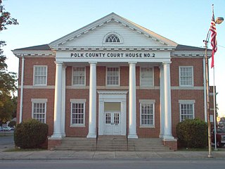
Polk County is a county located in the northwestern part of the U.S. state of Georgia. As of the 2010 census, the population was 41,475. The county seat is Cedartown. The county was created on December 20, 1851 by an act of the Georgia General Assembly and named after James K. Polk, the eleventh President of the United States.

Park County is one of the 64 counties in the U.S. state of Colorado. As of the 2010 census, the population was 16,206. The county seat is Fairplay. The county was named after the large geographic region known as South Park, which was named by early fur traders and trappers in the area.

Custer County is the tenth-least populous of the 64 counties in the U.S. state of Colorado. As of the 2010 census, the population was 4,255. The county seat is Westcliffe.

Silver Cliff is a statutory town that is the most populous town in Custer County, Colorado, United States. The population was 587 at the 2010 census, up from 512 in 2000.

Pembroke is a town in Plymouth County, Massachusetts, United States. The population was 17,837 at the 2010 census.

Madison is a town in Carroll County, New Hampshire, United States. The population was 2,502 at the 2010 census. Madison includes the village of Silver Lake and the village district of Eidelweiss.

Bandera is the county seat of Bandera County, Texas, United States, in the Texas Hill Country, which is part of the Edwards Plateau. The population was 857 at the 2010 census. It is part of the San Antonio Metropolitan Statistical Area.

Tysons, formerly known as Tysons Corner, is a census-designated place (CDP) and unincorporated community in Fairfax County, Virginia, United States. Located in Northern Virginia between the community of McLean and the town of Vienna along the Capital Beltway (I-495), it lies within the Washington Metropolitan Area. Tysons is home to two super-regional shopping malls—Tysons Corner Center and Tysons Galleria—and the corporate headquarters of numerous companies such as Intelsat, DXC Technology, Gannett, Hilton Worldwide, Cvent, Freddie Mac, Capital One, and Booz Allen Hamilton. Tysons is Fairfax County's central business district and a regional commercial center. It has been characterized as a quintessential example of an edge city. The population was 19,627 as of the 2010 census.
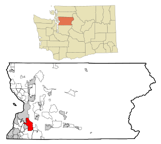
Silver Firs is a census-designated place (CDP) in Snohomish County, Washington, United States. The population was 20,891 at the 2010 census. It lies northeast of the city of Mill Creek. Silver Firs is one of two CDPs that were created out of the former Seattle Hill-Silver Firs CDP in 2010, the other being Eastmont.

Harrison Township is one of fifteen townships in Wayne County, Indiana, United States. As of the 2010 census, its population was 392 and it contained 138 housing units.

Silver Creek is an unincorporated community and census-designated place (CDP) in Silver Creek Township, Wright County, Minnesota, United States. As of the 2010 census, its population was 256. The community is located along Wright County Road 8 near 112th Street NW. Wright County Road 39 is nearby.

Tyler Run is a census-designated place (CDP) in York County, Pennsylvania, United States. The population was 1,901 at the 2010 census. The area was part of the Tyler Run-Queens Gate CDP at the 2000 census.

Queens Gate is a census-designated place (CDP) in York County, Pennsylvania, United States. The population was 1,464 at the 2010 census. The area was part of the Tyler Run-Queens Gate CDP at the 2000 census.

Eastmont is a census-designated place (CDP) in Snohomish County, Washington, United States. The population was 20,101 at the 2010 census. Eastmont is one of two CDPs that were created out of the former Seattle Hill-Silver Firs CDP in 2010, the other being Silver Firs. Eastmont is the location of Community Transit's Eastmont Park & Ride, which is serviced by Sound Transit Express route 513.


