Sima de las Cotorras (in English: Sinkhole of the Parrots/Parakeets) is a sinkhole located in the El Ocote Biosphere Reserve in western Chiapas, southern Mexico. It is one of a number of sinkholes in the area, all produced by tectonic and erosive processes on the region's limestone. Although not the largest and deepest of the area's sinkholes, it is best known because of a tourism project which focuses on the thousands of Mexican green parakeets who live there most of the year, flying in and out in circular patterns.
Sima de Cotorras Ecotourism Center was established in 1985 to give local Zoque families an alternate means of generating income, preserve the local environment and give younger generations a reason to not migrate from the area. The project has built a road, a restaurant and cabins for visitors, and offers rappelling into the sinkhole as well as guided tours to see the cave paintings, the tropical vegetation at the bottom of the formation and the areas around the sinkhole rim. However, most visitors are local and visit for a day only to see the parakeets. The Center has had its problems balancing ecological concerns with keeping it economically viable.
Location and environment
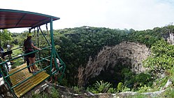
Entrance to ecotourism park
The sinkhole is part of a larger park called El Ocote Biosphere Reserve, located in the western part of the Mexican state of Chiapas, about 90 minutes from the state capital of Tuxtla Gutierrez.[1][2] It belongs to the municipality of Ocozocoautla de Espinoza, about 19km over rough roads from the town center.[3][4] This part of Chiapas is dominated by the Zoque people, who call the area Coita, a Zoque word that means “place of rabbits.”[5][6] The nearest community to the sinkhole is Piedra Parada, which has about 500 residents.[6]
The climate of the area is mostly warm and humid, with a rainy season from June to October, receiving an average of 1,500mm of precipitation per year.[6][7] It is in the Sierra Madre de Chiapas, at an altitude of about 820 meters above sea level. This area gets cold enough in the winter to need a light jacket.[3][4]
Most of the vegetation of the area has been wiped out or severely degraded by agriculture, forestry and other human activity.[7]
Geology of the sinkhole
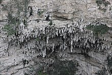
Portion of the wall of the sinkhole showing stalactites
The Sima de las Cotorras belongs to a Karst topography system, based on the folding, fracturing and erosion of limestone.[6][7] This particular system is defined by its drainage system, with the La Venta River on the surface and the main underground river being El Paraíso. Despite its proximity to the Pacific, drainage is towards the Gulf of Mexico.[6][7] Most of this ecological system is covered by the El Ocote Biosphere Reserve.[6]
There are two main forces that shape the landscape. Tectonic forces from the movement of the North American plate over the Farallon and Cocos plates creates anticline folds, with a northeasterly orientation. The folding creates cracks in the relatively soft rock and water running above and below erode in and around these fractures. The two processes have created a number of formations including canyons, arches, caves, waterfalls, small pools of water and sinkholes.[6][7] These same processes make the soil acidic and strewn with loose rock.[7]
These sinkholes are vertical depressions formed by the cracking, erosion and collapse of limestone over thousands of years.[1][6][7] The Sima de las Cotorras is 140 metres (460ft) meters deep, and 160 metres (520ft) in diameter, with a straight drop of 97 metres (318ft) meters.[1][8] The opening is elliptical, with the north and southwest rims elevated in relation to the rest. The low point of the rim is in the east.[9][7] The process reveals the layers of rock, and about 70 metres (230ft) meters down, stalactites and stalagmites can be seen among the layers from the surface.[3][10][11] There are also caves within the sinkhole walls, which have also been produced by erosion.[7] This type of sinkhole is similar to those found in the Yucatán, but in general these do not contain pooled water at the bottom.[4]
Biology of the sinkhole
Two beetles mating on a flower on the park.
Instead the interior of the sinkhole is home to a tropical forest, whose plant and animal life is distinct from that of the surrounding ecosystem.[3]
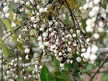
The wider reserve serves as a buffer area for the microclimate of the Sima de las Cotorras. Outside the sinkhole and up to its rim, the climate is drier, mostly grassland/shrub from cattle grazing, and areas called lomería, rocky areas with limited growth, mostly shrubs, due to dense limestone. In some of the higher elevations there are still some forests.[2] Around the sinkhole itself, there are many copal trees, Protium copal (family Burseraceae), which gave the sinkhole its original name of Sima del Copal.[3]
The interior of the sinkhole holds and preserves more moisture.[7] From its bottom grows a tropical deciduous rainforest microsystem with broadleafed species such as cedar, mahogany, Fabaceas espinosa and Burseraceas baja, Manilkara zapota, scrubs of the family Guaiacum and more, with trees reaching as high as 30 meters tall.[4][10][2] The plant species here are not found outside the sinkhole.[8]
The Sima's most famous resident is Psittacara holochlorus, the Mexican parrot, which is endangered. Chiapas is home to over 68% of Mexico's parrots (family Psittacidae). And many of Mexico's parrot species are endangered, mostly due to shrinking habitat, along with the illegal pet trade and other exploitation of the animals. There are an estimated 3,000 parrots associated with the sinkhole and they can be found there most of the year, with the exception November to January, when the weather is too cool for them. The forest of the sinkhole is also their nesting site.[2] From the evening until the early morning, the parrots are congregated in the sinkhole forest, where the noise they make can be quite loud.[1][10] The parrots’ noise will cease if a predator such as a falcon is seen nearby.[1] The parrots leave the sinkhole to look for food, which includes from mango trees in people's backyards as far away as Tuxtla Gutierrez. They leave the sinkhole in groups, flying in circles on wind currents in order to leave and enter.[1] Inside the sinkhole, the parrots are the most numerous kind of bird. Outside, it is dominated by small birds of the family Tyrannidae.[2]
Archeological site
Evidence of human habitation in the area goes back at least 7,500 years, with evidence of hunter/gatherers.[4] However, there were no major pre-Hispanic settlements in this area.[6] The area of the park was first explored and academically documented in the mid 20th century, noting local caves and archeological finds such as pottery. But documentation still remains sparse especially in comparison to other such sites in Mexico.[6]
The significant archeological find in and around the Sima de las Cotorras are cave paintings, arrowheads, and much later pottery shards, possibly Zoque.[1][6] The most important of these are the cave paintings, which number about 75.[1][3] On a rock outcropping on the north wall, there is a human figure with lance, and with a sun and moon above. One of the side caves has on its roof the outlines of hands made by blowing red ochre onto the wall.[4] Other images include circles, spirals and animals.[3][12] The appearance of cave painting in such a geological formation and especially so high up the sinkhole walls makes them a rarity, and the site is under consideration by UNESCO for protective status.[7]
Ecological park
The El Ocote Biosphere Reserve was established in 1972, extendingover 8 hectares, protecting over a hundred species of birds, and dozens of mammals, reptiles and insects, some endangered.[10][13] With the exception of the Sima de la Cotorras, the park has not been developed for tourism, and its formations are almost completely unknown outside of their region. The other sinkholes in the area get no tourism activity at all. The tourism activity based on the flight of the parrots has made the sinkhole relatively famous and it is now better known as the “sinkhole of the parrots” rather than its official name.[6][7]
Tourism activity here began with the establishment of the Sima de Cotorras Ecotourism Center in 1985 and the building of a road from the town of Ocozocoautla to the site.[2] The center was established to provide alternative work for the local Zoque people. Today it is run by the Tzamanguimó cooperative, which consists of a number of families all from the nearby community of Piedra Parada.[2][6]
The project is also registered with the federal government as an ecotourism site, with the aim of being sustainable, providing income for local residents with minimal impact. The group welcomes researchers as well as visitors onto the site.[2] The main challenge has been how to take advantage of the site without damaging it.[6] The ground is unstable and highly porous. Many underground cavities are still unknown, making building risky. The largest structure on the premises is the restaurant. Built near the rim, its site was chosen because of the stability of the rock, not because it was the most aesthetically pleasing place to put the structure. Waste disposal is a main issue because of the threat of groundwater contamination, prompting several composting activities. Bringing water, electricity and more are also challenges.[7]
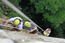
By far the main attraction of the site are the parrots that fly in and out of sinkhole each day, generally leaving in the early morning and returning at night.[3][2] It is also possible to rappel to the bottom of the sinkhole, as well as explore local caves and hike both in and around the sinkhole.[1][3][14]
Facade of the cabins for visitors, inside the ecological park of Sima de las Cotorras.Interior overview of the cabins inside the ecological park of Sima de las Cotorras.
Where possible constructions are based on local materials to allow them to blend into the local environment. Paving and path construction is based on local rock. Pre Hispanic architecture formed the basis of the buildings on the site, including the rock foundation seen on the restaurant building.[7] The Center has eight cabins for up to five persons each, a camping area and tours with local guides.[14]
Tourists practicing rappel, descending from Sima de las Cotorras.
It has eight cabins which can house five people each.[1] It currently has a restaurant, several cabins to house multiple people, a camping área, a path around the rim of the sinkhole, rappelling and tours to see the cave paintings and the rainforest that covers the sinkhole's floor.[2]
The Center has provided an alternative source of work other than agriculture and for some, a means for income when before they had none. Despite this, the project has not been claimed as a great success. According to theses done at the Universidad Intercultural de Chiapas, the tourism possibilities here have not been fully exploited.[2][6] As of 2016, only about 10 to 15 people per day visit the site.[5] Most visitors come by their own cars or through local ecoadventure tourism agencies.[6] Most tourists are between 41–60 years of age, followed by the 31-40 age bracket and those in the 18-30 year bracket. About half come from the state capital of Tuxtla Gutierrez, with about 13% from Mexico City, 12.5 from other parts of Mexico. Only about 2 percent are foreigners.[2]
The main problems for the site are the lack of promotion and poor access. The roads leading to the site are very poor, especially the last ten km, and signage is poor or non-existent. The park is difficult to access for those with disabilities. Most visitors learn of the site through word-of-mouth, with some from television and much fewer from other media.[2][7] The lack of services means that those who do come do not stay for long. Two-thirds come only to see the parrots, some will stay and eat at the restaurant, but very few stay the night.[2]
The project over the years has received intermittent support from various government institutions such as PEMEX, the Secretary of Tourism, SEMARNAT and the Comision Nacional para el Desarrollo de los Pueblos Indígenas, in areas such as finance, customer service and construction. But these interventions have not always been helpful, with functionaries using technical jargon and dismissing local knowledge of the area.[2] Changes in political parties has led to varying attitudes towards the project and its ecological focus, with errors being made such as cutting down trees to make way for cement electrical poles and the construction on non-composting toilets.[7]
At its height, the Center generated about 80 to 100 jobs directly,[7] but since the tourist demand has declined.[6] The project is specifically geared to keep young people in the area, but they have not shown sufficient interest in its continuation. Most members of the cooperative are between 50 and 80 years of age.[2][6][7] Only about 30% of the local population recognizes the area's intangible value, but 80% favor efforts to make the area better known.[6] Even with sufficient interest and promotion, the area is not suited for large-scale tourism. One reason is the need to keep ecological concerns first and the other is that alternative and eco-tourism are not major attractions for most Mexicans.[2][7]
Chiapas, officially the Free and Sovereign State of Chiapas, is one of the states that make up the 32 federal entities of Mexico. It comprises 124 municipalities as of September 2017 and its capital and largest city is Tuxtla Gutiérrez. Other important population centers in Chiapas include Ocosingo, Tapachula, San Cristóbal de las Casas, Comitán, and Arriaga. Chiapas is the southernmost state in Mexico, and it borders the states of Oaxaca to the west, Veracruz to the northwest, and Tabasco to the north, and the Petén, Quiché, Huehuetenango, and San Marcos departments of Guatemala to the east and southeast. Chiapas has a significant coastline on the Pacific Ocean to the southwest.
Tuxtla Gutiérrez is the capital and the largest city of the Mexican southeastern state of Chiapas. It is the seat of the municipality of the same name, the most developed and populated in the state. A busy government, commercial and services-oriented city, Tuxtla had one of the fastest-growing rates in Mexico in the last 40 years. Unlike many other areas in Chiapas, it is not a major tourist attraction, but a transportation hub for tourists coming into the state, with a large airport and a bus terminal.
San Cristóbal de las Casas, also known by its native Tzotzil name, Jovel, is a town and municipality located in the Central Highlands region of the Mexican state of Chiapas. It was the capital of the state until 1892, and is still considered the cultural capital of Chiapas.
Chiapa de Corzo is a small city and municipality situated in the west-central part of the Mexican state of Chiapas. Located in the Grijalva River valley of the Chiapas highlands, Chiapa de Corzo lies some 15 km (9.3 mi) to the east of the state capital, Tuxtla Gutiérrez. Chiapa has been occupied since at least 1400 BCE, with a major archeological site which reached its height between 700 BCE and 200 CE. It is important because the earliest inscribed date, the earliest form of hieroglyphic writing and the earliest Mesoamerican tomb burial have all been found here. Chiapa is also the site of the first Spanish city founded in Chiapas in 1528. The "de Corzo" was added to honor Liberal politician Angel Albino Corzo.
Soconusco is a region in the southwest corner of the state of Chiapas in Mexico along its border with Guatemala. It is a narrow strip of land wedged between the Sierra Madre de Chiapas mountains and the Pacific Ocean. It is the southernmost part of the Chiapas coast extending south from the Ulapa River to the Suchiate River, distinguished by its history and economic production. Abundant moisture and volcanic soil has always made it rich for agriculture, contributing to the flowering of the Mokaya and Olmec cultures, that were based on Theobroma cacao and rubber of Castilla elastica.
Sumidero Canyon is a deep natural canyon located just north of the city of Chiapa de Corzo in the state of Chiapas, in southern Mexico. The canyon's creation began around the same time as the Grand Canyon in the U.S. state of Arizona, by a crack in the area's crust and subsequent erosion by the Grijalva River, which still runs through it. Sumidero Canyon has vertical walls which reach as high as 1,000 metres (3,300 ft), with the river turning up to 90 degrees during the 13-kilometre (8.1 mi) length of the narrow passage.
The Chiapas Bridge is a steel bridge over a kilometer in length which spans the Nezahualcoyotl or Malpaso Dam in northern Chiapas, Mexico. Construction of the bridge began in 2002 and finished fourteen months later, voted the best infrastructure project in Mexico in 2004. The bridge and the highway it is part of cuts driving time from Mexico City to the state capital by 3.5 hours and makes the rural area in northern Chiapas more accessible and open to ecotourism.
Cerro Sarisariñama is a tepui, a flat-topped mountain in Jaua-Sarisariñama National Park at the far south-west of Bolívar State, Venezuela, near the border with Brazil. Its altitude range is between 300 m (980 ft) and 2,350 m (7,710 ft). The name of the mountain originates from the tale of local Ye'kuana Indians about an evil spirit living in caves up in the mountain and devouring human flesh with a sound "Sari... sari...".
The Petén–Veracruz moist forests is an ecoregion of the tropical and subtropical moist broadleaf forest biome found in Belize, Guatemala, and Mexico.
Ocozocoautla de Espinosa, colloquially Coita, is a town and municipality in the Mexican state of Chiapas. It is located in the western part of the state, 24 km west of Tuxtla Gutierrez covering parts of the Depresión Central and the Montañas del Norte. It is bordered to the north by Tecpatán, to the east by Berriozábal, Tuxtla Gutiérrez and Suchiapa, to the south by Villaflores and to the west by Jiquipilas and Cintalapa. The name comes from the Nahua language and means ‘forest of ocozote trees’. ‘De Espinosa’ was added in 1928 to honor Raymundo Enríquez Espinosa who was the first governor of the state of Chiapas. Ocozocoautla gained city status in 1926. The climate is warm and humid and the vegetation is mostly high and medium rainforest.
Mapastepec is a town and municipality in the southeastern state of Chiapas, Mexico. Its name derives from the place name mapachtepec, "Hill of the Raccoon", a compound of the Nahuatl words mapachi ("raccoon") and tepetl ("mountain").
Palenque is a city and municipality located in the north of the state of Chiapas, Mexico. The city was named almost 200 years before the nearby Mayan ruins were discovered in the 18th century. The area has a significant indigenous population, mostly of the Ch'ol people, a Mayan descendant. The city is the only urban area in a municipality of over 600 communities, and is surrounded by rainforest. Deforestation has had dramatic effects on the local environment, with howler monkeys occasionally seen in the city as they seek food. While most of the municipality's population is economically marginalized, working in agriculture, the Palenque archeological site is one of the most important tourist attractions for the area and the state of Chiapas. It is the poorest major city in the state of Chiapas.
Sima Humboldt is an enormous sinkhole located on the summit of the plateau of Sarisariñama tepui in Bolívar State, Venezuela. It is unusual for several reasons, including its enormous size and depth, its location on the top of the only forested tepui, having a patch of forest on its base and also due to the weathering process that formed this sinkhole. The feature is named after scientist and explorer Alexander von Humboldt.
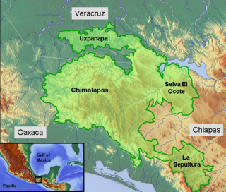
The Selva Zoque, which includes the Chimalapas rain forest, is an area of great ecological importance in Mexico. Most of the forest lies in the state of Oaxaca but parts are in Chiapas and Veracruz. It is the largest tract of tropical rainforest in Mexico, and contains the majority of terrestrial biodiversity in the country. The forest includes the Selva El Ocote, a federally-protected biosphere reserve, but is otherwise not yet protected. Despite the rich ecology of the region, a 2003 study that focused on bird populations stated that "the fauna of the heart of the Chimalapas, including its vast rainforests, have seen little or no study". As it is an impoverished region, efforts to preserve the ecology are often at odds with demands to improve the economy.
The Malpaso Dam, officially known as the Nezahualcóyotl Dam, is located in the Centro region of Chiapas, Mexico near the border with Tabasco and Veracruz. It was the first of several major dams built on the Grijalva River to generate hydroelectric energy and has the second largest reservoir in Mexico, after the Belisario Dominguez Dam. Construction of the dam occurred in the 1960s and flooded not only the riverbed but also hectares of rainforest and farmland, various towns and villages and archeological sites. These include the former town of Quechula, whose 16th century Dominican church will appear when water is at low levels, and the archeological site of San Isidro which contains one of only two known double Mesoamerican ball courts. Commissioning of the dam's 1,080 MW power station began in 1969 and ended in 1977. The reservoir and later construction of a federal highway has spurred ecotourism in the area.
The Regional Museum of Anthropology and History of Chiapas is the largest museum in Tuxtla Gutiérrez in Chiapas and one of the most important of its kind in Mexico. It primarily consists of two main halls with one dedicated to the state’s Mesoamerican archeology and the other to the history of the state starting from the Spanish conquest. The archeological display focus on the native Zoque and Mayan cities, and the historical displays extend in time until the early 20th century. In addition to its permanent collection, it also has a temporary exhibit hall and auditorium to host events such as book signings, summer classes, conferences and more.
The cuisine of Chiapas is a style of cooking centered on the Mexican state of the same name. Like the cuisine of rest of the country, it is based on corn with a mix of indigenous and European influences. It distinguishes itself by retaining most of its indigenous heritage, including the use of the chipilín herb in tamales and soups, used nowhere else in Mexico. However, while it does use some chili peppers, including the very hot simojovel, it does not use it as much as other Mexican regional cuisines, preferring slightly sweet seasoning to its main dishes. Large regions of the state are suitable for grazing and the cuisine reflects this with meat, especially beef and the production of cheese. The most important dish is the tamal, with many varieties created through the state as well as dishes such as chanfaina, similar to menudo and sopa de pan. Although it has been promoted by the state of Chiapas for tourism purposes as well as some chefs, it is not as well known as other Mexican cuisine, such as that of neighboring Oaxaca.
The monk parakeet, also known as the Quaker parrot, is a species of true parrot in the family Psittacidae. It is a small, bright-green parrot with a greyish breast and greenish-yellow abdomen. Its average lifespan is 20–30 years. It originates from the temperate to subtropical areas of Argentina and the surrounding countries in South America. Self-sustaining feral populations occur in many places, mainly in North America and Europe.
Mezcalapa is a municipality in the Mexican state of Chiapas, located approximately 71 kilometres (44 mi) northwest of the state capital of Tuxtla Gutiérrez. Its municipal seat is Raudales Malpaso.
Selva El Ocote is a biosphere reserve in Mexico. It includes mid-elevation and highland rain forests and extensive caverns.
1 2 3 4 5 6 7 8 9 10 11 12 13 14 15 16 17 18 19 Alarcon Hernandez, Perla (February 2010). Implicaciones y Contradicciones del Ecoturismo en la Sima de las Cotorras, Ocozocoautla de Espinoza, Chiapas (masters). El Colegio de la Frontera Sur.
1 2 3 4 5 6 7 8 9 10 "Es la "Sima de las Cotorras" un atractivo más de Chiapas". NOTIMEX. Mexico City. February 23, 2008.
1 2 3 4 5 6 David Diaz Gomez (October 13, 2002). "Tierra de fosas, selvas y cascadas". Reforma. Mexico City. p.14.
1 2 3 4 5 6 7 8 9 10 11 12 13 14 15 16 17 18 19 20 21 Espinosa Perez, Laura Irene (2016). Las otras joyas, una aventura de altura, Un acercamiento de la sensibilización turística de la Ribera Piedra Parada (bachelors). Universidad Intercultural de Chiapas San Cristobal de las Casas.
This page is based on this Wikipedia article Text is available under the CC BY-SA 4.0 license; additional terms may apply. Images, videos and audio are available under their respective licenses.