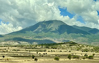
Tanzanite is the blue and violet variety of the mineral zoisite, caused by small amounts of vanadium. Tanzanite belongs to the epidote mineral group. Tanzanite is only found in Simanjiro District of Manyara Region in Tanzania, in a very small mining area approximately 7 km (4.3 mi) long and 2 km (1.2 mi) wide near the Mererani Hills.
Manyara Region is one of Tanzania's 31 administrative regions. The regional capital is the town of Babati. According to the 2012 national census, the region had a population of 1,425,131, which was lower than the pre-census projection of 1,497,555. For 2002–2012, the region's 3.2 percent average annual population growth rate was tied for the third highest in the country. It was also the 22nd most densely populated region with 32 people per square kilometre.

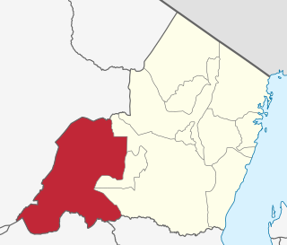
Babati Rural District is a district of Manyara Region of Tanzania, East Africa. The administrative capital of the district is Babati town, 172 km (107 mi) south of Arusha. The district covers an area of 6,069 km2 (2,343 sq mi), a large proportion (640 km2) of which is covered by the water bodies of Lake Babati, Lake Burunge and Lake Manyara. The district is bordered to the north by Arusha Region, to the south east by Simanjiro District, to the south by Dodoma Region, to the south west by Hanang District, and to the north west by Mbulu District. Babati Urban District is located within the district.

Arusha Region is one of Tanzania's 31 administrative regions and is located in the north of the country. The region's capital and largest city is the city of Arusha. The region is bordered by Kajiado County and Narok County in Kenya to the north, the Kilimanjaro Region to the east, the Manyara and Singida Regions to the south, and the Mara and Simiyu regions to the west. Arusha Region is home to Ngorongoro Conservation Area, a UNESCO World Heritage Site. The region is comparable in size to the combined land and water areas of the state of Maryland in the United States.

Meatu District is one of the five districts of the Simiyu Region of Tanzania. It is bordered to the north by the Itilima District, to the west by the Maswa District and Shinyanga Region to the east by the Arusha Region, to the southeast by the Manyara Region and to the south by the Singida Region. Its district capital is the town of Mwanhuzi.

Same is one of the seven districts of the Kilimanjaro Region of Tanzania. It is bordered to the north by the Mwanga District, to the northeast by Kenya, to the south and southeast by the Korogwe District and Lushoto District of Tanga Region, and to the west by Simanjiro District of Manyara Region. The district capital is the town of Same, Tanzania. The south Pare Mountains are located within the district's boundaries and so is a part of Mkomazi National Park. According to the 2002 Tanzania National Census, the population of the Same District was 212,235. The population had risen to 300,303 according to the 2022 Tanzania National Census.
Mwanga is one of the seven districts of the Kilimanjaro Region of Tanzania. The district covers an area of 1,831 km2 (707 sq mi), It is bordered to the northeast by Kenya, to the northwest by the Moshi Rural District, to the southwest by Simanjiro District of Manyara Region, and to the south by the Same District. Its administrative seat is the town of Mwanga. The tallest peak in the district is Kindoroko at 2,100m in the North Pare Mountains that are located entirely within the district. According to the 2022 Tanzania National Census, the population of Mwanga District was 148,763.
Kilindi is one of eleven administrative districts of Tanga Region in Tanzania. The District covers an area of 6,444 km2 (2,488 sq mi). It is bordered to the east by the Handeni District and Handeni Town Council, to the south west by the Kiteto District and north west by the Simanjiro District of Manyara Region. Kilindi District is bordered to the south by Gairo District and Kilosa District of Morogoro Region. The district created from Handeni District in 2002. The district seat (capital) is the town of Songe. According to the 2022 census, the district has a total population of 398,391.
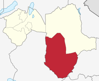
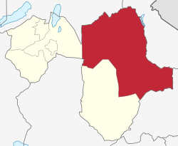
Kiteto District is one of the six districts of the Manyara Region of Tanzania. It is bordered to the north by the Simanjiro District, to the east by the Tanga Region and to the south and west by the Dodoma Region. The district headquarters are located in Kibaya.

Meru District, officially the Meru District Council is one of seven districts of the Arusha Region of Tanzania.The District is bordered to the north by Longido District, to the east by Siha and Hai Districts of Kilimanjaro Region, to the south by Simanjiro District of Manyara Region, and to the west by Arusha Rural District and Arusha Urban District. It covers an area of 1,266 km2 (489 sq mi). The district is comparable in size to the land area of Faroe Islands. Meru District has an max elevation of 3,800 m (12,500 ft) at Rhino Point on Mount Meru. The administrative capital of the district is Usa River. According to the 2022 Tanzania National Census, the population of Meru District council was 331,603.

Terrat is a ward and village in the Simanjiro district about 80 km from Arusha in Tanzania. The population in the area is Maasai who regularly gather in the village for its market where animals, cloths, kitchen utensils etc. are sold. The buildings in the village are one-storeyed, mostly cement walled with corrugated iron roofs, scattered at the banks of a small river. According to the 2012 census, the ward has a population of 8,586.
Makiba is an administrative ward in the Meru District of the Arusha Region of Tanzania. The ward is bordered by Mererani ward located in Manyara Region which is the only source of Tanzanite on earth. Makiba is a transit ward to Merenani from Arusha Region, the largest importer of the gemstone. According to the 2002 census, the ward has a total population of 12,056.
Mbuguni is an administrative ward in the Meru District of the Arusha Region of Tanzania. The road that goes to Mererani, Manyara Region actually passes through Mbuguni ward. Making Mbuguni a trade route for the Tanzanite gemston. According to the 2002 census, the ward had a total population of 14,880.

Oltroto or also spelt as Oltoroto is a Tanzanian administrative ward located in Arusha Rural District of the Arusha Region. Oltoroto means "a place to collect chalk" in Maasai language. The ward is bordered by Ilkiding'a to the north, Sokon II to the east, Moivo to the south and finally Olorieni and Kiranyi wards to the west. The ward is home to plateau mountain called Oldonyo Sapuk and on the east of the ward is Kivesi Hill at 1,897 meters tall. The ward covers an area of 11.85 km2 (4.58 sq mi), and has an average elevation of 1,699 m (5,574 ft). According to the 2012 census, the ward had a total population of 15,451
Mto wa Mbu is an administrative ward and town in the Monduli district of the Arusha Region of Tanzania. According to the 2012 census, the ward had a total population of 11,405. The name Mto wa Mbu means " The river of Mosquitoes " in the Swahili Language.
Sombetini is one of the 19 administrative wards of the Arusha City Council located in the Arusha Region of Tanzania. The ward is bordered by Elerai ward to the north, Unga Limited and Sokon I wards to the east. The wards of Olasiti and Terrat are located in to west and south respectively. The ward covers an area of 5.173 km2 (1.997 sq mi), According to the 2012 census, the ward had a total population of 48,268.

Babati Urban District is one of the six districts of the Manyara Region of Tanzania. Babati Urban District is surrounded by Babati Rural District. The administrative capital of the district is Babati town.
Orkesumet is a town and a ward in the Manyara Region of Tanzania. It is the district headquarter of Simanjiro District.
Terrat is an administrative ward in the Arusha Urban District located in the Arusha Region of Tanzania. Not to be confused with Terrat ward in Simanjiro, Manyara region. According to the 2012 census, the ward has a total population of 21,790.
Jumanne Mhero Ngoma was a Tanzanian man who was credited by the Tanzanian government with discovering the gemstone tanzanite.