
The Aare or Aar is the main tributary of the High Rhine and the longest river that both rises and ends entirely within Switzerland.

The geography of Switzerland features a mountainous and landlocked country located in Western and Central Europe. Switzerland's natural landscape is marked by its numerous lakes and mountains. It is surrounded by five countries: Austria and Liechtenstein to the east, France to the west, Italy to the south and Germany to the north. Switzerland has a maximum north–south length of 220 kilometres (140 mi) and an east–west length of about 350 kilometres (220 mi).

The Alpine region of Switzerland, conventionally referred to as the Swiss Alps, represents a major natural feature of the country and is, along with the Swiss Plateau and the Swiss portion of the Jura Mountains, one of its three main physiographic regions. The Swiss Alps extend over both the Western Alps and the Eastern Alps, encompassing an area sometimes called Central Alps. While the northern ranges from the Bernese Alps to the Appenzell Alps are entirely in Switzerland, the southern ranges from the Mont Blanc massif to the Bernina massif are shared with other countries such as France, Italy, Austria and Liechtenstein.

The Bernese Alps are a mountain range of the Alps, located in western Switzerland. Although the name suggests that they are located in the Berner Oberland region of the canton of Bern, portions of the Bernese Alps are in the adjacent cantons of Valais, Fribourg and Vaud, the latter being usually named Fribourg Alps and Vaud Alps respectively. The highest mountain in the range, the Finsteraarhorn, is also the highest point in the canton of Bern.

The river Ticino is the most important perennial left-bank tributary of the Po. It has given its name to the Swiss canton through which its upper portion flows.

The Engadin or Engadine is a long high Alpine valley region in the eastern Swiss Alps in the canton of Graubünden in southeasternmost Switzerland with about 25,000 inhabitants. It follows the route of the Inn from its headwaters at Maloja Pass in the southwest running roughly northeast until the Inn flows into Austria, little less than one hundred kilometers downstream. The En/Inn subsequently flows at Passau into the Danube, making it the only Swiss river to drain into the Black Sea. The Engadine is protected by high mountain ranges on all sides and is famous for its sunny climate, beautiful landscapes and outdoor activities.

The Swiss rail network is noteworthy for its density, its coordination between services, its integration with other modes of transport, timeliness and a thriving domestic and trans-Alp freight system. It is made necessary by strong regulations on truck transport, and is enabled by properly coordinated intermodal logistics.

Monte Rosa is a mountain massif in the eastern part of the Pennine Alps, on the border between Italy and Switzerland (Valais). The highest peak of the massif, amongst several peaks of over 4,000 m (13,000 ft), is the Dufourspitze, the second highest mountain in the Alps and western Europe, after Mont Blanc. The east face of the Monte Rosa towards Italy has a height of about 2,400 metres (7,900 ft) and is the highest mountain wall of the Alps.

The Bernese Oberland, sometimes also known as the Bernese Highlands, is the highest and southernmost part of the canton of Bern. It is one of the canton's five administrative regions. It constitutes the Alpine region of the canton and the northern side of the Bernese Alps, including many of its highest peaks, among which the Finsteraarhorn, the highest in both range and canton.
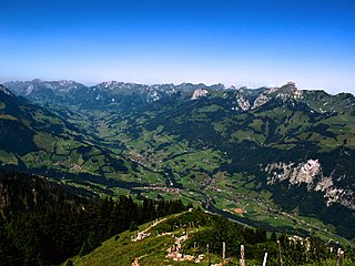
The Simmental is an alpine valley in the Bernese Oberland of Switzerland. It expands from Lenk to Boltigen, in a more or less south-north direction (Obersimmental), and from there to the valley exit at Wimmis near Spiez it takes a west-east orientation (Niedersimmental). It comprises the municipalities of Lenk, St. Stephan, Zweisimmen, Boltigen, Oberwil, Därstetten, Erlenbach, Diemtigen and Wimmis. The Simme flows through the valley.

The Vorderrhein, or Anterior Rhine, is the left of the two initial tributaries of the Rhine. It is longer than the Hinterrhein, but has a lower discharge than the latter at their confluence, which marks the beginning of the Alpine Rhine section.
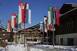
Lenk im Simmental is a municipality in the Obersimmental-Saanen administrative district in the canton of Bern in Switzerland.

The Kander is a river in Switzerland. It is 44 kilometres (27 mi) long and has a watershed of 1,126 square kilometres (435 sq mi). Originally a tributary of the Aare, with a confluence downstream of the city of Thun, since 1714 it flows into Lake Thun upstream of the city.

The Wildhorn is a mountain of the Alps, straddling the border between the Swiss cantons of Bern and Valais. At 3,250 metres (10,663 ft) above sea level, it is the highest summit of the Bernese Alps west of the Gemmi Pass. It forms a large glaciated massif, about 10 km wide, extending between the Sanetsch Pass and the Rawil Pass. Along with the Muverans, the Diablerets and the Wildstrubel, the Wildhorn is one of the four distinct mountain massifs of the Bernese Alps that lie west of the Gemmi Pass. The massif of the Wildhorn is at the centre between the valleys of the Saane, Simme and the Rhone (Valais). It comprises several distinct summits, including the Arpelistock, Le Sérac, the Geltenhorn, the Sex Noir, the Sex Rouge, the Schnidehorn and the Six des Eaux Froides. The main crest is between the glaciers named Tungelgletscher and Glacier du Wildhorn. South of the main summit is the almost equally high summit of Mont Pucel. The Wildhorn is surrounded by several large mountain lakes: the Lac de Sénin, the Lauenensee, the Iffigsee, the Lac de Tseuzier and the Lac des Audannes. The Tungelgletscher, on the north-east face, was measured as 1.9 km in length in 1973.

The Vanil Noir is a mountain of the Fribourg Prealps, located on the border between the cantons of Fribourg and Vaud in western Switzerland. Reaching a height of 2,389 metres above sea level, the Vanil Noir is the highest summit of the canton of Fribourg and of the Alpine foothills lying north of the Saane and Simme. It is also the northernmost point in the canton of Vaud above 2,300 metres and the most prominent summit of both cantons.

The Lötschberg line is a railway in Switzerland, connecting Spiez in the canton of Bern with Brig in the canton of Valais. It crosses the Bernese Alps, from the Bernese Oberland to Upper Valais, through the Lötschberg Tunnel in the middle of the line. Together with the Simplon Tunnel south of Brig, it constitutes one of the major railways through the Alps and an important north-south axis in Europe. The Lötschberg axis is backed by the lower and longer Lötschberg Base Tunnel, part of the New Railway Links through the Alps project.

Overdeepening is a characteristic of basins and valleys eroded by glaciers. An overdeepened valley profile is often eroded to depths which are hundreds of metres below the lowest continuous surface line along a valley or watercourse. This phenomenon is observed under modern day glaciers, in salt-water fjords and fresh-water lakes remaining after glaciers melt, as well as in tunnel valleys which are partially or totally filled with sediment. When the channel produced by a glacier is filled with debris, the subsurface geomorphic structure is found to be erosionally cut into bedrock and subsequently filled by sediments. These overdeepened cuts into bedrock structures can reach a depth of several hundred metres below the valley floor.
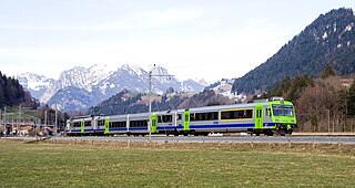
The Spiez–Zweisimmen railway is a single-track standard-gauge line in Switzerland that is currently operated by BLS AG. It was formerly owned by the Spiez-Erlenbach-Zweisimmen-Bahn (SEZ), also called the Simmentalbahn. The line runs from Spiez through the Simmental to Zweisimmen. It is marketed as part of the GoldenPass Line between Lucerne and Montreux, which also includes the metre-gauge Brünig Railway and Montreux–Lenk im Simmental line and part of the standard-gauge Lake Thun Railway.

The area of Oeschinen Lake and Kander river valley in Switzerland have been subject of multiple large landslides during the Holocene. Both the number and timing of landslides is controversial, with the most recent estimates stating that the large Kander landslide occurred about 3,210 years ago and the smaller Oeschinen Lake landslide 2,300 years ago. Both may have been caused by earthquakes, and the latter landslide generated the Oeschinen Lake. More recent landslides have occurred, and unstable rock masses occur in the landslide area.

The GoldenPass Express is a luxury railway service that operates between Montreux, on Lake Geneva, and Interlaken, in the Bernese Oberland, in Switzerland. The train is owned and operated jointly by the Montreux Oberland Bernois Railway (MOB) and BLS AG (BLS). As such, it uses the MOB's 1,000 mm gauge line between Montreux and Zweisimmen. In Zweisimmen, the train cars change gauges in order to operate on BLS' 1,435 mm gauge lines from Zweisimmen to Spiez and then from Spiez to Interlaken. The automatic gauge changeover, which adjusts both the track gauge and the height of the car body, is believed to the first of its kind in the world when implemented on 11 December 2022.
