
Purnia is the fourth largest city of Bihar and is emerging as the largest economic hub in North Bihar. It serves as the administrative headquarters of both Purnia district and Purnia division in the Indian state of Bihar. It is well known for its favourable climate like Darjeeling and has an abundance of resources for human settlements and economic activities.

Saharsa is a city and municipal corporation in the Saharsa District in the eastern part of the state of Bihar, India. It is situated near the eastern banks of the Kosi River. It serves as the administrative headquarters for the Saharsa District and is also the Divisional headquarters of the Kosi Division.
Supaul is a town and a municipality that is headquarters of Supaul district in the Indian state of Bihar. Supaul is the administrative headquarters of this district. There Are 11 block under the Supaul district Supaul, Kishanpur, Saraigarh-Bhaptiyahi, Pipra, Triveniganj, Raghopur, chhatapur, Nirmali, Marauna, Basantpur and pratapganj.

The East Central Railway is one of the 19 railway zones in India. It is headquartered at Hajipur and comprises Sonpur, Samastipur, Danapur, Pt. Deen Dayal Upadhyaya, and Dhanbad divisions.

Jamalpur is a city in the Indian state of Bihar. It is situated 9 km from the Munger city centre. Jamalpur is a part of Munger-Jamalpur twin cities.It is main railhead for reaching Munger city.

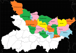
Madhepura district is one of the thirty-eight districts of Bihar state, India, and Madhepura town is the administrative headquarters of this district. Madhepura district is a part of Kosi division.

Supaul district is one of the thirty-eight districts of Bihar, India. The town Supaul is the district's administrative headquarters. The district, which was split from the former Saharsa district on 14 March 1991, occupies 2,410 km2 (931 sq mi).

Nawada district is one of the thirty-eight districts of the Indian state of Bihar. Nawada is its administrative headquarters. The district is the easternmost district of the Magadh division, one of the nine administrative divisions of Bihar. The area of the modern district was historically part of the Magadha, Shunga and Gupta empires. Koderma and Giridih districts of the state of Jharkhand lie on the southern border of the district; it also shares borders with the Gaya, Nalanda, Sheikhpura, and Jamui districts of Bihar.

Saharsa is one of the thirty-eight districts of Bihar, India. Saharsa city is the administrative headquarters of this district. Saharsa district is a part of the Kosi Division and it became a district on 1 April 1954 and has subsequently become smaller with other districts being carved from it, most notably Madhepura in 1981.
Nirmali is a town and a notified area in Supaul district in the Indian state of Bihar.

The Koshi Barrage is a sluice across the Koshi river that carries vehicular, bicycle, and pedestrian traffic between Saptari district and Sunsari district of Nepal. It is near the International border with India. It was built between 1958 and 1962 and has 56 gates. It was constructed after the Koshi Agreement was signed between the Government of Nepal and India on April 25, 1954. The barrage was designed and built by Joseph and Company Limited, India. The Koshi Tappu Wildlife Reserve is roughly 3–4 miles north of the barrage.
Sihaul is a village with population of about 11,000 in the sub-district of Satar Kataiya, where it ranks as the third most populous village. The sub-district forms a part of Saharsa district in the state Bihar, India. The geographical area of the village is 9 km2 (3.5 sq mi) and it is the third biggest village by area in the sub-district. Population density of the village is 1287 persons per km2.
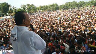
Choudhary Mehboob Ali Kaiser is an Indian politician and Member of Parliament from Khagaria Lok Sabha Constituency. He started his political career from Indian National Congress. He was Member of Legislative Assembly where he represented Simri-Bakhtiarpur constituency for three terms. He also served as Cabinet Minister in Bihar Government. After being denied ticket by Indian National Congress for General Elections in 2014, he joined Lok Janshakti Party days before 2014 general election and successfully contested from Khagaria constituency.
Simri Bakhtiarpur Assembly constituency is an assembly constituency in Saharsa district in the Indian state of Bihar.
Abdul Ghafoor: was an Indian politician who served as Minister of Minority Welfare in government of Bihar from 20 November 2015 to 26 July 2017. He served as a member of the Bihar Legislative Assembly representing Mahishi vidhan sabha for 4 terms in 1995, 2000, 2010 and 2015. His political party was Rashtriya Janta Dal (RJD).
North Bihar is a term used for the region of Bihar, India, which lies north of the Ganga river.
Baghwa is a village situated in the south west corner of Saharsa district in the north Indian state of Bihar. It is a small village by population, but its area is not that small. This village is also known as IAS/IPS officer village. It is surrounded by two water channels, being Sathrath and Balwa dhar (koshi) which part it from Khagaria.
Biraul is the subdivisional headquarters of Biraul subdivision, consisting of six blocks of Darbhanga district in Bihar, India. The blocks are Biraul, Ghanshyampur, Gorabauram, Kiratpur, Kusheshwar Asthan and Kusheshwar Asthan East. This region covers the south-eastern part of Darbhanga district.

Harnaut station is a railway station in India. It is a station in the city of Harnaut, and is situated on the Bakhtiyarpur–Tilaiya line route passing through Nalanda. Its service recording traffic of more than 1.5k passengers, and more than 25 trains per day. The Harnaut station is connected to most of the major cities in India by the railway network. Harnaut has well connected trains running frequently to New Delhi railway station, Patna Junction, Varanasi Junction, and Howrah Junction. Harnaut is well connected with Gaya Junction, Bihar Sharif Junction, Rajgir railway station, Tilaiya railway station, Bhagalpur railway station, and Kiul Junction through daily passenger and express train services.
Rajdham is a village in Gogari block of Khagaria district of Bihar State, India.
