Related Research Articles

A tunnel is an underground or undersea passageway. It is dug through surrounding soil, earth or rock, or laid under water, and is enclosed except for the portals, commonly at each end. A pipeline is not a tunnel, though some recent tunnels have used immersed tube construction techniques rather than traditional tunnel boring methods.

Hatton is a major town in the Nuwara Eliya District of Central Province, Sri Lanka governed by the Hatton-Dickoya Urban Council. Hatton is a major centre of the Sri Lankan tea industry.

Badulla is the capital and the largest city of Uva Province situated in the lower central hills of Sri Lanka. It is the capital city of Uva Province and the Badulla District.

Nawalapitiya is a town in Kandy District, Sri Lanka. It is governed by an Urban Council. It is 38 km (24 mi) from Kandy and 112 km (70 mi) from Colombo, at a height of 589 m (1,932 ft) above sea level. It is located on the banks of the Mahaweli Ganga. The area was developed during the colonisation of the island by the British, as one of the colony's centres of Coffee Production.
The Sri Lanka Railway Department is Sri Lanka's railway owner and primary operator. As part of the Sri Lankan government, it is overseen by the Ministry of Transport. Founded in 1858 as the Ceylon Government Railway, it operates the nation's railways and links Colombo with other population centres and tourist destinations.
Udarata Menike is a daytime passenger train that runs between Colombo and Badulla in Sri Lanka.

Demodera is a town in the central highlands of Sri Lanka, located in the Badulla District of Uva Province.
"Podi Manike" is a Sri Lankan passenger train running from Colombo Fort to Badulla. This journey covers about 300 km and is renowned for being the most beautiful train journey in Sri Lanka, especially the stretch from Nanuoya to Ella. It takes about 10 hours to complete the journey.

The Main Line is a major railway line in the rail network of Sri Lanka and considered by many to be one of the most scenic train journeys in all of Asia. The line begins at Colombo Fort and winds through the Sri Lankan hill country to reach Badulla.

The coastal line is a major railway line in Sri Lanka, running between Colombo Fort and Beliatta, via Galle and Matara. Operated by Sri Lanka Railways, the line includes some of the busiest rail services in the country. The line has been extended to Beliatta on 8 April 2019 and is proposed to be extended to Kataragama, via Hambantota. With a designed maximum speed of 100 km/h (62 mph) between Kalutara and Matara, and a maximum speed of 120 km/h (75 mph) between Matara and Beliatta, the line is one of the fastest in Sri Lanka.

Talawakelle is a town in Nuwara Eliya District in the Central Province, Sri Lanka, governed by an Urban Council. It is the centre of the Dimbula tea planting district, the largest tea growing area in Sri Lanka. It is situated on A7 Colombo-Nuwara Eliya highway. The altitude of Talawakelle is 1,198 metres (3,930 ft). Talawakelle railway station is one of the major stops of Udarata or Main railway line. The town is administered by Talawakelle-Lindula urban council.
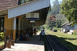
Ella is a small town in the Badulla District of Uva Province, Sri Lanka governed by an Urban Council. It is approximately 200 kilometres (120 mi) east of Colombo and is situated at an elevation of 1,041 metres (3,415 ft) above sea level. The area has a rich bio-diversity, dense with numerous varieties of flora and fauna. Ella is surrounded by hills covered with cloud forests and tea plantations. The town has a cooler climate than surrounding lowlands, due to its elevation. The Ella Gap allows views across the southern plains of Sri Lanka.

Hatton Station is a railway station on the Main (Colombo-Badulla) railway line in Sri Lanka. It is situated between Rozella and Kotagala railway stations. It is 173.06 kilometres (107.53 mi) along the railway line from the Colombo Fort Railway Station at an elevation of about 1,262.5 m (4,142 ft) above sea level.

Demodara railway station is the 76th and third last railway station on the Main Line, and is 277.71 km (172.56 mi) away from Colombo. It is located 912.5 m (2,994 ft) above mean sea level and 8 km (5.0 mi) from Badulla, the capital city of Uva Province. All the trains that run on the Main Line, including the Podi Menike and Udarata Menike express trains stop at the station.
The Uma Oya Hydropower Complex (also internally called Uma Oya Multipurpose Development Project or UOMDP) is an irrigation and hydroelectric complex currently under construction in the Badulla District of Sri Lanka. Early assessments of project dates back to 1989, when the first studies was conducted by the country's Central Engineering and Consultancy Bureau. The complex involves building a dam across Dalgolla Oya, and channelling water over a 3,975 m (13,041 ft) tunnel to Mathatilla Oya, both of which are tributaries of the Uma Oya. At Mathatilla Oya, another dam is constructed to channel 145,000,000 m3 (5.1×10⁹ cu ft) of water per annum, via a 15,290 m (50,160 ft) headrace tunnel to the Uma Oya Power Station, where water then discharged to the Alikota Aru via a 3,335 m (10,942 ft) tailrace tunnel. The Alikota Aru is a tributary of the Kirindi Oya.
Colombo - Badulla Night Mail Train is a night time passenger and mail train that runs between Colombo and Badulla in Sri Lanka.
Moragalla Railway Tunnel or Lion's Mouth Tunnel is the second longest railway tunnel in Sri Lanka.
Pattipola Railway Tunnel, or the Summit Tunnel, is the third longest and the highest railway tunnel in Sri Lanka. It is located approximately 3 km (1.9 mi) away from the Pattipola railway station, straddling the boundary of the Badulla and Nuwara Eliya Districts.

Great Western railway station is the 61st railway station on the Main Line, and is 199.3 km (123.8 mi) away from Colombo.
Pattipola is a village that is mostly located in Badulla District, Uva Province with a small portion in Nuwara Eliya District of Central Province, Sri Lanka.
References
- ↑ Perera, G. F. (1925). The Ceylon Railway: The Story of Its Inception and Progress. The Ceylon Observer. p. 518.
- ↑ Ratnasinghe, Aryadasa (3 August 2004). "It happened 146 years ago: Cutting the first sod of earth for the Railway". Daily News . Retrieved 7 September 2017.
- 1 2 Ratnasinghe, Aryadasa (3 January 1999). "A historic journey in 1864". Sunday Times . Retrieved 7 September 2017.
- ↑ Ferguson, John (1887). Ceylon in the Jubilee Year. Asian Educational Services. p. 299.
- ↑ Ratnasinghe, Aryadasa. "Through tunnels and rocks on the main line". Sunday Times . Retrieved 11 September 2017.
- ↑ Ranatunga, D. C. (1 October 2010). "Tale of the "Yakada Yaka"". Daily FT . Retrieved 7 September 2017.
- ↑ Cave, Henry W. (1910). The Ceylon Government Railway: A Descriptive and Illustrated Guide. Cassell & Co. Ltd. p. 132.
- ↑ Ratnasinghe, Aryadasa (13 June 1999). "Train to Badulla". Sunday Times . Retrieved 7 September 2017.
- ↑ "Poolbank". The History of Ceylon Tea. Dilmah Ceylon Tea Company PLC. Retrieved 7 September 2017.