Thiruneermalai is a neighborhood in the city of Tambaram, situated within the Chennai Metropolitan Area, Tamil Nadu, India.
Brahmakulam is a census town in the Thrissur district in the state of Kerala, India.
Chandameta-Butaria is a town and a nagar panchayat in Chhindwara district in the state of Madhya Pradesh, India.
Dommara Nandyal is a census town in Mylavaram Mandal, Kadapa district, Andhra Pradesh, India. Dommara Nandyal is under the constituency of Jammalamadugu. Dommara Nandyal is situated along the bank of the Penna River. Mylavaram dam is constructed just 3 km away from it, that supplies water for drinking. Dommara Nandyal is also famous for people making silk sarees with their own hands. Veparala and Moragudi, beside of Dommaranadyala, are also the handloom towns.
Edaganasalai is a Municipality in Salem district in the state of Tamil Nadu, India.
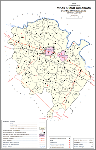
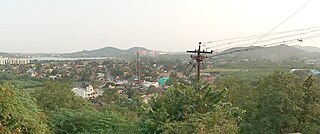
Gosainganj, also spelled Goshainganj or Gosaiganj is a town and nagar panchayat in Lucknow district of Uttar Pradesh, India. It is the seat of a community development block, which is included in the tehsil of Mohanlalganj. As of 2011, its population is 9,649, in 1,685 households. The starting point of the Purvanchal Expressway i.e. Chand Saray village is situated 2.5 km away from Gosainganj.
Indergarh is a city and a municipality in Bundi district in the Indian state of Rajasthan. There is a famous Temple of Bijasan Mata situated here and every year in Navaratri huge numbers of people come here. The temple is surrounded by the Aravali range.
Kandwa is a census town in Varanasi district in the Indian state of Uttar Pradesh.

Musafirkhana is a town and tehsil in Amethi district in Indian state of Uttar Pradesh. The word "Musafirkhana" means "Sarai," or "Dharamshala". Musafirkhana is located 32 km northwest of district headquarters Amethi.
Nawa is a city, tehsil headquarters, panchayat samiti, and a municipality in Didwana Kuchaman District in the Indian state of Rajasthan. It is the Biggest Salt Market of Rajasthan.
Payal is a city in Ludhiana district in the Punjab, India.

Shorapur, is a city and taluka in Yadgir district in the Indian state of Karnataka and a historical place. Surapura was the land of the famous prince of Surapura aasthana, Raja Venkatappa Nayaka, the young rebel freedom fighter against British rule.

Singaperumal Koil is a satellite town city of Chennai located between Chengalpattu and Maraimalai Nagar in Chengalpattu district in the Indian state of Tamil Nadu. It is a part of the area Chennai Metropolitan Development Authority (CMDA) and a vital locality in Chennai Metropolitan Area.
Thiruporur is a panchayat town in Chengalpattu district in the Indian state of Tamil Nadu. The Thiruporur Kandaswamy temple is situated in the center of the town. There is a large temple tank in the vicinity of the temple. Thiruporur is located on Old Mahabalipuram Road and is flanked by Kelambakkam on one side and Alathur Pharmaceutical Industrial Estate on the other side, both of which are also on Old Mahabalipuram Road.
Tirwa is a town in Kannauj district in the Indian state of Uttar Pradesh.

Veerapandi is a panchayat gram in Theni district in the Indian state of Tamil Nadu.
Kerur is a town in Bagalkot district in Karnataka, which located on NH 218. It has an average elevation of 617 meters (2024 feet). It's the birthplace of Jagadish Shettar, a former Chief Minister of Karnataka. Kerur is a Town Panchayat city in the district of Bagalkot, Karnataka. The Kerur city is divided into 16 wards for which elections are held every five years. The Kerur Town Panchayat has a population of 19,731 of which 9,929 are males while 9,802 are females as per report released by Census India 2011.

Dasarahalli is a northwestern suburb of Bangalore in Bangalore Urban district in the state of Karnataka, India. The place is well known for its religious establishments such as Jalahalli Sree Ayyappan Temple, Shri Kari Maramma Devi Temple, Bagalgunte Maramma temple, Mallasandra Sri Prasanna Anjenya temple, Kaliyamma Temple, CSI Holy Cross Church, and St Dionysius Orthodox Church. Residential areas like Vaishnavi Rathnam, Casa Serene, Shantiniketan Apartments, Sobha ruby apartments, Ayyappa Nagar, Pipeline road, Grape Garden and Prashanth Nagar S.M road that includes the main Parayil Verghese family home. Police stations in the locality are Bagalgunte PS, Peenya PS and Gangammagudi PS. Nearby Hospitals are People tree Hospital, GJM Hospital, Prakriya Hospitals and Sree Ayyappan Temple Medical Center.
Dathapuram is a census town located in R.S Kondapuram Mandal, Kadapa district, Andhra Pradesh, India. Dathapuram is under the constituency of Jammalamadugu. Dathapuram is situated along the bank of the Penna River. Gandikota dam is constructed just 13 km away from it, that supplies water for drinking. Dathapuram is also famous for people making silk sarees with their own hands.
