Sinsen is a mixed residential and commercial area in Grünerløkka borough of Oslo, Norway. The westernmost part of Sinsen is part of the borough Nordre Aker.
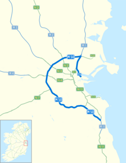
The M50 motorway is a C-shaped orbital motorway in Dublin and the busiest motorway in Ireland. The current route was built in various sections over the course of 27 years, from 1983 to 2010. It begins at Dublin Port, running northward through the Dublin Port Tunnel and along a portion of the Airport Motorway. It then turns west at its junction with the M1, circling the northern, western and southern suburbs of Dublin, before merging with the M11 at Shankill in South East Dublin. The road forms part of European route E01.
The Grorud Line is a 13.0-kilometer long (8.1 mi) line on the Oslo Metro between Tøyen and Vestli in Oslo, Norway. Built as a mix of underground, at ground level and as an elevated line, it runs through the northern part of Groruddalen, serving such neighborhoods as Grorud, Romsås and Stovner. Line 5 runs along the entire line four times per hour. Line 4 runs between Vestli and Økern before branching off on the Løren Line to get onto the Ring Line. With 40,000 daily riders, the Grorud Line is the busiest branch of the metro.

The Ring Line is the newest rapid transit loop line of the Oslo Metro of Oslo, Norway. It connects to the Sognsvann Line in the west and the Grorud Line in the east; along with these two lines and the Common Tunnel, the Ring Line creates a loop serving both the city centre and Nordre Aker borough. The 5.0 kilometres (3.1 mi)-long line has three stations: Nydalen, Storo and Sinsen. Four-fifths of the line runs within two tunnels, with the 1.0-kilometer (0.62 mi) section between Storo and Sinsen, including both stations, being the only at-grade part. The line connects to the Grorud Line north of Carl Berners plass and with the Sognsvann Line north of Ullevål stadion.

Carl Berners plass is an underground rapid transit station located on the Grorud Line of the Oslo Metro, and a tram stop on the Sinsen Line of the Oslo Tramway. The square also has a bus stop for lines 20, 21, 31 and 33. Located at Helsfyr in Oslo, Norway, the area has a mixture of apartment buildings and small businesses. The station is the first metro station on the Grorud Line after it branches off from the shared Common Tunnel. North of the station, the Ring Line branches off from the Grorud Line. The station is served by line 5 of the metro and Line 17 of the tramway, with four hourly departures during regular hours. The tram operates every 10 minutes during regular hours.

Carl Berners plass is a square in Oslo, Norway. It is located in the borough Helsfyr, south of Sinsen. The Sinsen Line of the Oslo Tramway runs over the square. The colloquial expression for the square is just "Carl Berner". Around the square is a large number of shops as well as inexpensive restaurants. At the southern end of the area is the large Tøyen Park.
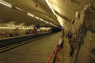
Sinsen is a rapid transit station on the Ring Line of the Oslo Metro. It is located at Sinsen in the Sagene borough of Oslo, Norway. Next to the station is the tram station Sinsenkrysset, that has been part of the Sinsen Line of the Oslo Tramway since 1939. The station opened on 20 August 2006, as part of the first section of the Ring Line. The station is served by line 6 of the metro, as well as several local bus services. Sinsen is a mixed residential and commercial area.

The Asker Line is a 9.5-kilometre (5.9 mi) railway line between Asker and Lysaker in Norway. The line runs along the same corridor as the Drammen Line, offering increased capacity, speed and regularity on the rail network west of Oslo. The first part opened in 2005, and in 2011 an extension opened from Sandvika to Lysaker. An extension to Skøyen in Oslo will perhaps be built after 2020. Most of the railway is in tunnel and is dimensioned for 160 km/h (99 mph) running. The entire railway is electrified at 15 kV 16.7 Hz AC. The first section cost 3.7 billion kr, while the second is budgeted at NOK 2.7 billion.

AS Oslo Sporveier is a defunct municipal owned company responsible for public transport in Oslo, Norway. It was created in 1924 to take over the city's two private tram companies. In 1927 its started with bus transport, including from 1940 to 1968 trolleybuses. Since 1966 rapid transit and from 1985 water buses have also been operated by the company. It was split into two separate companies in 2006; Kollektivtransportproduksjon took over the operation while Oslo Public Transport Administration was responsible for buying the services, fare regulation and marketing. The latter merged into Ruter in 2008, when the Oslo Sporveier brand was discontinued.
Elisenberg Station is an unfinished railway station within the Oslo Tunnel on the Drammen Line in Oslo, Norway. The ghost station was partially built during the construction of the tunnel between 1971 and 1980, but has never been put into use. It is located between Nationaltheatret Station and Skøyen Station, at Elisenberg in Frogner. A 220-meter (720 ft) long center platform and part of the access way has been built, but never completed. While the station initially was not put into use because of lack of funds to complete it, it is now unlikely that it will ever be completed, as the need for a station has disappeared and an opening would need a large investment of funds.

Norwegian National Road 150, also known as Ring 3 and formerly Store Ringvei is a beltway limited-access road which circumnavigates Oslo, Norway. It runs from Ryen, through the Sinsen Interchange to Lysaker in Bærum.

The Løren Line is a 1.6-kilometer (1.0 mi) line of the Oslo Metro. Located entirely underground, it runs through the neighborhoods of Sinsen, Løren and Økern in Bjerke, creating a connection between the Ring Line with the Grorud Line. The line features one station, Løren. It is served by metro trains which run down the Grorud Line and then connect to the Ring Line. It allows for higher capacity on the metro as more passengers a transported via the Ring Line instead of through the congested Common Tunnel. Construction started in June 2013 and the line opened on 3 April 2016.
Oslo Package 3 is a political agreement and plan for investments of 53 billion kr in Oslo and Akershus, Norway. It involves financing for road and public transport infrastructure, as well as operating subsidies to public transport in the period 2008–27. It will be part of the National Transport Plan 2010–19. In addition to state grant, the main financing will be through toll ring around Oslo. The plan is a follow-up on its predecessors, the Oslo Package 1 and Oslo Package 2.

The Sinsen Line is part of the Oslo Tramway on the east side of the city. Most of the line is served by line 17, although the northernmost tip (Grefsen–Torshov) is served by line 13 which otherwise runs on the Grünerløkka–Torshov Line. Both services use SL95 articulated trams.

Oslo Package 1 was a political agreement and plan for introducing an urban toll ring around Oslo, Norway, and making 31 investments to road infrastructure in Oslo and Akershus. The package was approved in 1988, and toll charges were introduced in 1990. It was supplemented by Oslo Package 2, which included a similar scheme for public transport. In 2008, they were both replaced by Oslo Package 3.

Bispelokket was a Norwegian three-level stack interchange roundabout in Bjørvika, Oslo. European Route E18 and Norwegian National Road 162 jointed at this point, which also served as the official traffical centre of the city. The new roundabout at Postgirobygget is from October 31, 2011, the new traffical centre of Oslo.

The Fjord City is an urban renewal project for the waterfront part of the center of Oslo, Norway. The first redevelopment was at Aker Brygge during the 1980s. Bjørvika and Tjuvholmen followed up during the 2000s, while the remaining parts of the Port of Oslo will be developed in the 2010s. The port will be relocated to Sørhavna. The planning is performed by the Oslo Waterfront Planning Office. Major investments in the area include a new Central Railway Station, an already completed Oslo Opera House, and the commercial buildings in the Barcode Project. Several large cultural institutions will be moved to Bjørvika, including moving the Oseberg Ship, Oslo Public Library, and the Munch Museum. The main barrier between the city and the fjord will disappear when European Route E18 is relocated to the Bjørvika Tunnel.

The Rodeløkka Line is a former line of the Oslo Tramway of Norway. It was in use from 1900 to 1961, serving the neighborhood of Rodeløkka. After closing, the southern part of the line was designated as part of the Sinsen Line. The Rodeløkka Line was built by Kristiania Kommunale Sporveie (KKS) in 1900, and was subsequently taken over by Kristiania Sporveisselskab (KSS) in 1905. In 1924, the ownership was transferred to Oslo Sporveier. It was served by Line 9 until 1949, when it was replaced by a bus service. In 1955, a new route from Carl Berners plass to Rodeløkka was built, and the line was served by Line 13 until 1961, when the service was terminated. The tracks were removed between 1962 and 1964.

Riksvei 4 (Rv4) is a national road which is the main route north from Oslo, Norway. The road runs through Nittedal, Hadeland and Toten to the lake of Mjøsa.

The N40 road is a national primary road in Cork City, Ireland, which forms an orbital route around the south side of the city, linking the N22 at Ballincollig to the N25 at the Dunkettle Interchange. The present N40 was created on 23 February 2012 via statutory instrument. The newly designated N40 was formed from parts of both the N22 and N25. It is intended that once the Cork North Ring Road is completed, that the N40 will comprise a complete orbital route of Cork city.