
Prayagraj division, formerly known as Allahabad division, is an administrative unit of Indian state of Uttar Pradesh.

Prayagraj district, also known as Allahabad district, is the most populous district in the Indian state of Uttar Pradesh. Prayagraj city is the district headquarters of this district. The District is divided into blocks within tehsils. As of 2011, there are 20 blocks in eight tehsils. The Prayagraj division includes the districts of Pratapgarh, Fatehpur, Kaushambi and Prayagraj, with some western parts that had previously part of Allahabad District becoming part of the new Kaushambi District. The administrative divisions are Phulpur, Koraon, Meja, Sadar, Soraon, Handia, Bara, Shringverpur and Karchana.

Kaushambi district is a district in the state of Uttar Pradesh in India. Manjhanpur is the district headquarters. The district was carved from Prayagraj district on 4 April 1997. Manauri Bajar connects Prayagraj and Kaushambi districts by railway over a bridge on SH-95. Manjhanpur is south-west of Prayagraj on the north bank of the Yamuna river, about 55 kilometres (34 mi) from the city. It is surrounded by Chitrakoot district on the south, Pratapgarh district on the north, Prayagraj district on the east and Fatehpur district on the west. Kaushambi is part of Prayagraj division. The nearest railway station, in Bharwari, connects with Delhi, Prayagraj, Kolkata, Gaya and Kanpur.
Manjhanpur is a town, nagar palika and the district headquarters of Kaushambi district in the Indian state of Uttar Pradesh. It is very old Town. The nearest railway station is Bharwari which is 11 km (6.8 mi) from Manjhanpur.Bharwari is the main railway station in Kaushambi district & it is well connected to major cities like Delhi, Kolkata, Prayagraj, Varanasi, Kanpur, Lucknow etc. There are so many autos, taxis& buses are available to reach Bharwari railway station. The Nearest Airport is Bamrauli which is 45 km (28 mi) away from Manjhanpur. Manjhanpur also has several Quality Hospital. District Hospital and several hospital are equipped with state of art technology. A newly inaugurated bus stop has started the services of transportation, it is well connected with Prayagraj, Rajapur, chitrakoot, Kanpur etc.
Rajapur is a town and tehsil of Chitrakoot district in the Indian state of Uttar Pradesh. It is situated along the bank of river Yamuna. It has its nickname as "Tulsi Dhaam" after great Hindi poet Goswami Tulsidas, who is the writer of holy "Ram Charit Manas" along with many other religious books of Hindus. There is a temple devoted to Tulsidas where part of the original "Hand written Scripture" of Ramcharitmanas is still available, although some pages may be missing. Rajapur is linked with Kaushambi district on the opposite bank of river Yamuna.
Rura is a Nagar Panchayat in Kanpur Dehat District in Uttar Pradesh state of the India. The town is situated on the banks of Lower Ganga canal. The district headquarters is 15 km away at Mati. The town is located at a distance of 49 km from famous industrial and educational hub of Kanpur Nagar.
Tundla is a town and a municipal board in Firozabad district in the Indian state of Uttar Pradesh.

Unchahar is a town and nagar panchayat in Raebareli district in the Indian state of Uttar Pradesh. It serves as the headquarters of a tehsil as well as a community development block. It is located on Lucknow Allahabad Highway, 115 km from Lucknow, 85 km from Allahabad. The place is well connected by rail and roads to nearby cities of Kanpur, Lucknow, and Allahabad. Unchahar is also a constituency of Uttar Pradesh Legislative assembly.
Fatehpur is a city in the state of Uttar Pradesh, India. The city is situated between the rivers Ganga and Yamuna. The city has been named after Babu Fateh Chandra who helped Rani Lakshmi Bai in freedom fight as well. It is located 120 km (75 mi) south of state capital Lucknow.

Kara is an old township situated near Sirathu, on the banks of river Ganges, 69 km (43 mi) west of the city of Prayagraj in Kaushambi district in Uttar Pradesh state in India. It was capital of a very big region for centuries under the Delhi Sultanate and Jaunpur Sultanate rule.

Uttar Pradesh is the most populous state in India with a population of nearly 200 million people. The economy of Uttar Pradesh is the third largest of all the states in India. At current prices, the gross state domestic product (GSDP) of Uttar Pradesh is estimated to be Rs. 20.48 trillion in 2022–23. Merchandise exports from Uttar Pradesh reached US$21.03 billion in FY22.
Mandhana is a town in the Kanpur district of the Indian state of Uttar Pradesh, situated about 20 kilometres (12 mi) from Kanpur on the Grand Trunk Road to Delhi. As of the 2011 Census of India, the town had 213 households with a population of 993 of which 504 were male and 489 female. It has a 60% literacy rate and is 5 kilometres (3.1 mi) from Chobepur, its sister town. It also falls within the Kanpur metropolitan area. The language commonly spoken is Hindi with accent and tone of Kannauji. The IIT Kanpur is just 7 kilometres from Mandhana and also houses some of the successful alumnus of the institute. Mandhana is also known for private institutes like Maharana Pratap Engineering College and Rama University.
Jhandapur is a village in Sirathu Tehsil of Kaushambi District in Uttar Pradesh, India. Jhandapur is situated between the main railway line of the Delhi-Howrah route and the Grand Trunk Road. Shujatpur Railway Station is the nearest railway station. It is 1 km from Shujatpur Railway Station, 10 km from Manjhanpur, the district headquarters of Kaushambi District,Nearest city is Prayagraj(Allahabad) around 50km and around 600 km from New Delhi. Jhandapur has a population of around 10000. Main income source of people is farming,business and jobs in Gulf countries.
Daranagar is a town in Kaushambi, a suburb of Allahabad, in Uttar Pradesh, India. The town is located approximately 17 km to the north of the district headquarters of Manjhanpur and is known for the main Pilgrim Center and it is situated at the bank of ganga river. The main attraction in the town is the Daranagar Tirtha, dedicated to Bhagwan Shri Rishabhdev. In addition to these well known monuments, there are many other temples, such as Hanuman Temple, Jain Temple, Jwala Devi Temple, Ram Jaanki Temple and Kalbhairav Temple. Daranagar is known for the Shia Jama Masjid Syedwarah and the Sunni Shahi Jama Masjid built by Dara Shikoh, the son of the famous Mughal emperor Shah Jahan.
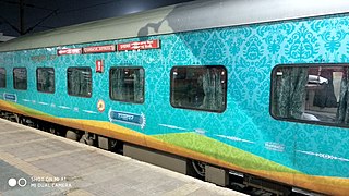
The 12275 / 12276 Prayagraj Junction railway station - New Delhi Humsafar Express is a Superfast Express train of the Humsafar Express category belonging to Indian Railways - North Central Railway zone that runs between Prayagraj Junction railway station and New Delhi in India. It holds the record for longest distance between consecutive passenger halts. It is the seventh-fastest-running train in India. Earlier it used to run as 12275/76 Allahabad - New Delhi Duronto Express of Duronto Express category from 9 February 2010 to 14 September 2019 before being converted to Humsafar Express.

Prayag Junction railway station is an important railway station in Prayagraj district, Uttar Pradesh. It serves Prayag town in Prayagraj. It consists of three platforms. The NR is developing the neighbouring Prayagraj sangam station as a coaching terminal. It is designed by architect M K Singh in the year 2018. There will be five new platforms, two washing lines, and a new station building with basement.
Manauri is a town of Prayagraj, Uttar Pradesh state of India. It is a market, 18 km west of Prayagraj city headquarter. It lies on the border of Prayagraj and Kaushambi district of Uttar Pradesh. On this town, a Railway Station lying nearby on the New Delhi - Howrah main line and an Air Force Station nearby on NH-2 is also named. Due to proximity of the Town with main Railway line and National highway, it has developed into a local trade market. The town has a huge population of more than 15 thousand, both of Hindus and Muslims. The main occupation is grains, vegetable and fruits agriculture along with traditional works like metal works, blacksmith, carpenter, glass works, and construction labours.
Manauri railway station is situated in Manauri bajar, Prayagraj district, Uttar Pradesh, India. Its station code is MRE. It is one of the major railway stations for Kaushambi district and west area of Prayagraj district
Manikpur Junction railway station is a railway station in Manikpur town of Chitrakoot district, Uttar Pradesh on Prayagraj–Jabalpur section. It is 99 km away from Prayagraj Junction. It has 4 platforms. Passenger and Superfast trains halt here.
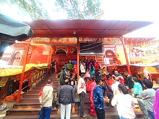
Sheetla Devi Temple is a Hindu temple dedicated to the mother goddess Shitala, located in Kara, a town located near Sirathu, on the banks of river Ganges in Kaushambi district of Uttar Pradesh. It is one of the 51 Shakti Peethas in Shaktism denomination of Hinduism. The deity of the temple is regarded as the Kuldevi of Purvanchal. It is also known as Kada Dham, Sheetlan and Sheetla Dham, Kada.
