| Sirevåg | |
|---|---|
| Village | |
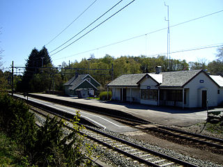
View of the village railway station | |
 Sirevåg Location in Rogaland county  Sirevåg Sirevåg (Norway) | |
| Coordinates: 58°30′13″N05°48′07″E / 58.50361°N 5.80194°E Coordinates: 58°30′13″N05°48′07″E / 58.50361°N 5.80194°E | |
| Country | Norway |
| Region | Western Norway |
| County | Rogaland |
| District | Jæren |
| Municipality | Hå |
| Area [1] | |
| • Total | 0.7 km2 (0.3 sq mi) |
| Elevation [2] | 15 m (49 ft) |
| Population (2015) [1] | |
| • Total | 627 |
| • Density | 896/km2 (2,320/sq mi) |
| Time zone | CET (UTC+01:00) |
| • Summer (DST) | CEST (UTC+02:00) |
| Post Code | 4364 Sirevåg |

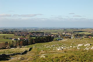
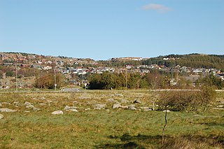
Sirevåg is a village in Hå municipality in Rogaland county, Norway. The village is located in the southeastern part of the municipality, about 5 kilometres (3.1 mi) northwest of the village of Hellvik in neighboring Eigersund municipality. The village of Ogna sits immediately north of Sirevåg. The Sørlandet Line (traditionally called the Jæren Line) runs through Sirevåg, with the Jæren Commuter Rail stopping at Sirevåg Station. [3]

Hå is a municipality in Rogaland county, Norway. It is the southernmost municipality in the traditional district of Jæren. The administrative centre of the municipality is the village of Varhaug. Other villages in Hå include Brusand, Hæen, Nærbø, Obrestad, Ogna, Sirevåg, and Vigrestad.

Rogaland[²ruːɡɑlɑn](

Norway, officially the Kingdom of Norway, is a Nordic country in Northwestern Europe whose territory comprises the western and northernmost portion of the Scandinavian Peninsula; the remote island of Jan Mayen and the archipelago of Svalbard are also part of the Kingdom of Norway. The Antarctic Peter I Island and the sub-Antarctic Bouvet Island are dependent territories and thus not considered part of the kingdom. Norway also lays claim to a section of Antarctica known as Queen Maud Land.
The main source of income in Sirevåg is shrimp harvesting and processing, fishing, and agriculture. The main agricultural activities in this area is raising dairy cows, beef cows, pigs, sheep, and fur farming. Growing potatoes is also common.

Fishing is the activity of trying to catch fish. Fish are normally caught in the wild. Techniques for catching fish include hand gathering, spearing, netting, angling and trapping. “Fishing” may include catching aquatic animals other than fish, such as molluscs, cephalopods, crustaceans, and echinoderms. The term is not normally applied to catching farmed fish, or to aquatic mammals, such as whales where the term whaling is more appropriate. In addition to being caught to be eaten, fish are caught as recreational pastimes. Fishing tournaments are held, and caught fish are sometimes kept as preserved or living trophies. When bioblitzes occur, fish are typically caught, identified, and then released.

Agriculture is the science and art of cultivating plants and livestock. Agriculture was the key development in the rise of sedentary human civilization, whereby farming of domesticated species created food surpluses that enabled people to live in cities. The history of agriculture began thousands of years ago. After gathering wild grains beginning at least 105,000 years ago, nascent farmers began to plant them around 11,500 years ago. Pigs, sheep and cattle were domesticated over 10,000 years ago. Plants were independently cultivated in at least 11 regions of the world. Industrial agriculture based on large-scale monoculture in the twentieth century came to dominate agricultural output, though about 2 billion people still depended on subsistence agriculture into the twenty-first.
Sirevåg has a very large mole/breakwater protecting its harbour.
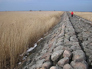
A mole is a massive structure, usually of stone, used as a pier, breakwater, or a causeway between places separated by water. The word comes from Middle French mole, ultimately from Latin mōlēs, meaning a large mass, especially of rock; it has the same root as molecule and mole, the chemical unit of measurement. A mole may have a wooden structure built on top of it that resembles a wooden pier. The defining feature of a mole, however, is that water cannot freely flow underneath it, unlike a true pier. The oldest known mole is at Wadi al-Jarf, an ancient Egyptian harbor complex on the Red Sea.
The 0.7-square-kilometre (170-acre) village has a population (2015) of 627, giving the village a population density of 896 inhabitants per square kilometre (2,320/sq mi). [1]

Population density is a measurement of population per unit area or unit volume; it is a quantity of type number density. It is frequently applied to living organisms, and most of the time to humans. It is a key geographical term. In simple terms population density refers to the number of people living in an area per kilometer square.