
Interstate 5 (I-5) is the main north–south Interstate Highway on the West Coast of the United States, running largely parallel to the Pacific Coast of the contiguous U.S. from Mexico to Canada. It travels through the states of California, Oregon, and Washington, serving several large cities on the West Coast, including San Diego, Los Angeles, Sacramento, Portland, and Seattle. It is the only continuous Interstate highway to touch both the Mexican and Canadian borders. Upon crossing the Mexican border at its southern terminus, the highway continues to Tijuana, Baja California, as Mexican Federal Highway 1 (Fed. 1). Upon crossing the Canadian border at its northern terminus, it continues to Vancouver as British Columbia Highway 99 (BC 99).

The Rogue River in southwestern Oregon in the United States flows about 215 miles (346 km) in a generally westward direction from the Cascade Range to the Pacific Ocean. Known for its salmon runs, whitewater rafting, and rugged scenery, it was one of the original eight rivers named in the Wild and Scenic Rivers Act of 1968. Beginning near Crater Lake, which occupies the caldera left by the explosive volcanic eruption and collapse of Mount Mazama, the river flows through the geologically young High Cascades and the older Western Cascades, another volcanic province. Further west, the river passes through multiple exotic terranes of the more ancient Klamath Mountains. In the Kalmiopsis Wilderness section of the Rogue basin are some of the world's best examples of rocks that form the Earth's mantle. Near the mouth of the river, the only dinosaur fragments ever discovered in Oregon were found in the Otter Point Formation, along the coast of Curry County.

Mount McLoughlin is a dormant steep-sided stratovolcano, or composite volcano, in the Cascade Range of southern Oregon and within the United States Sky Lakes Wilderness. It is one of the volcanic peaks in the Cascade Volcanic Arc, within the High Cascades sector. A prominent landmark for the Rogue River Valley, the mountain is north of Mount Shasta, and south-southeast of Crater Lake. It was named around 1838 after John McLoughlin, a Chief Factor for the Hudson's Bay Company. Mount McLouglin's prominence has made it a landmark to Native American populations for thousands of years.
Pacific Highway is the name of several north–south highways in the Pacific Coast region of the Western United States, either by legislation officially designating it as such or by common usage.

State Route 14 (SR 14) is a north–south state highway in the U.S. state of California that connects Los Angeles to the northern Mojave Desert. The southern portion of the highway is signed as the Antelope Valley Freeway. Its southern terminus is at Interstate 5 in the Los Angeles neighborhoods of Granada Hills and Sylmar just immediately to the south of the border of the city of Santa Clarita. SR 14's northern terminus is at U.S. Route 395 (US 395) near Inyokern. Legislatively, the route extends south of I-5 to SR 1 in the Pacific Palisades area of Los Angeles; however, the portion south of the junction with I-5 has not been constructed. The southern part of the constructed route is a busy commuter freeway serving and connecting the cities of Santa Clarita, Palmdale, and Lancaster to the rest of the Greater Los Angeles area. The northern portion, from Vincent to US 395, is legislatively named the Aerospace Highway, as the highway serves Edwards Air Force Base, once one of the primary landing strips for NASA's Space Shuttle, as well as the Naval Air Weapons Station China Lake that supports military aerospace research, development and testing. This section is rural, following the line between the hot Mojave desert and the forming Sierra Nevada mountain range. Most of SR 14 is loosely paralleled by a rail line originally built by the Southern Pacific Railroad, and was once the primary rail link between Los Angeles and Northern California. While no longer a primary rail line, the southern half of this line is now used for the Antelope Valley Line of the Metrolink commuter rail system.

U.S. Route 99 (US 99) was a main north–south United States Numbered Highway on the West Coast of the United States until 1964, running from Calexico, California, on the Mexican border to Blaine, Washington, on the Canadian border. It was assigned in 1926 and existed until it was replaced for the most part by Interstate 5. Known also as the "Golden State Highway" and "The Main Street of California", US 99 was important throughout much of the 1930s as a route for Dust Bowl immigrant farm workers to traverse the state. Large portions are now California State Route 99 (SR 99), Oregon's Routes 99, 99W, and 99E, and Washington's SR 99. The highway in Washington connected to British Columbia Highway 99, whose number was derived from that of US 99, at the Canada–US border.

Tehachapi Pass is a mountain pass crossing the Tehachapi Mountains in Kern County, California. Traditionally, the pass marks the northeast end of the Tehachapis and the south end of the Sierra Nevada range.

The Siskiyou Mountains are a coastal subrange of the Klamath Mountains, and located in northwestern California and southwestern Oregon in the United States. They extend in an arc for approximately 100 miles (160 km) from east of Crescent City, California, northeast along the north side of the Klamath River into Josephine and Jackson counties in Oregon. The mountain range forms a barrier between the watersheds of the Klamath River to the south and the Rogue River to the north. Accordingly, much of the range is within the Rogue River – Siskiyou and Klamath national forests, and the Pacific Crest Trail follows a portion of the crest of the Siskiyous.

Donner Pass is a 7,056-foot-high (2,151 m) mountain pass in the northern Sierra Nevada, above Donner Lake and Donner Memorial State Park about 9 miles (14 km) west of Truckee, California. Like the Sierra Nevada themselves, the pass has a steep approach from the east and a gradual approach from the west.
U.S. Route 199 (US 199) is a U.S. Highway in the states of California and Oregon. The highway was established in 1926 as a spur of US 99, which has since been replaced by Interstate 5 (I-5). US 199 stretches 80 miles (130 km) from US 101 near Crescent City, California northeast to I-5 in Grants Pass, Oregon. The highway is the northern portion of the Redwood Highway. In Oregon, US 199 is officially known as Redwood Highway No. 25. The majority of the road in California is the Smith River Scenic Byway, a National Forest Scenic Byway. The first roadway, a plank road, from Crescent City was established in May 1858, and before the US 199 designation was applied to the highway, the roadway was designated Highway 25 and Route 1.

The Siskiyou Trail stretched from California's Central Valley to the Columbia River in Washington State; modern-day Interstate 5 follows this pioneer path. Originally based on existing Native American foot trails winding their way through river valleys, the Siskiyou Trail provided the shortest practical travel path between early settlements in California and Oregon.

The Northwestern Pacific Railroad is a 271-mile (436 km) mainline railroad from the former ferry connections in Sausalito, California north to Eureka, with a connection to the national railroad system at Schellville. The railroad has gone through a complex history of different ownership and operators but has maintained a generic name of reference as The Northwestern Pacific Railroad, despite no longer being officially named that.

The Central Oregon & Pacific Railroad is a Class II railroad operating between Northern California and Eugene, Oregon, United States. It was previously a mainline owned by the Southern Pacific Railroad (SP) between Eugene and Weed, California via Medford, Oregon. SP sold the route on December 31, 1994, in favor of using its route to Eugene via Klamath Falls, Oregon and Cascade Summit.
Oregon Route 58, also known as the Willamette Highway No. 18, is a state highway in the U.S. state of Oregon. The route, signed east–west, runs in a southeast–northwest direction, connecting U.S. Route 97 north of Chemult with Interstate 5 south of Eugene. It links the Willamette Valley and Central Oregon, crossing the Cascade Range at Willamette Pass. OR 58 is generally a modern two-lane highway with a speed limit of 55 mph (88 km/h), built through the Willamette National Forest in the 1930s.

Siskiyou Summit is a summit on Interstate 5 (I-5) in the U.S. state of Oregon. It is distinct from Siskiyou Pass, which is a nearby, historical mountain pass. Siskiyou Summit is situated in the Siskiyou Mountains, approximately 4 miles (6.4 km) north of the California border. At 4,310 feet (1,310 m), it is the highest point on Interstate 5. When the highway was rebuilt on its current alignment, road cutting lowered the elevation of the summit by 49 feet (15 m).
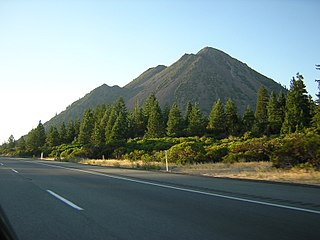
Black Butte is a cluster of overlapping dacite lava domes in a butte, a satellite cone of Mount Shasta. It is located directly adjacent to the northbound lanes of Interstate 5 at milepost 742 between the cities of Mount Shasta and Weed, California. The I-5 freeway crosses a 3,912 ft (1,192 m) pass, Black Butte Summit, at the western base of the lava domes. The lava domes were extruded at the foot of the cone of Shastina following the period of its major eruptions about 9,000–10,000 years ago.

Interstate 80 (I-80) is a part of the Interstate Highway System that runs from San Francisco, California, to Teaneck, New Jersey. The portion of the highway in the US state of Utah is 197.51 miles (317.86 km) long through the northern part of the state. From west to east, I-80 crosses the state line from Nevada in Tooele County and traverses the Bonneville Salt Flats—which are a part of the larger Great Salt Lake Desert. It continues alongside the Wendover Cut-off—the corridor of the former Victory Highway—US Route 40 (US-40) and the Western Pacific Railroad Feather River Route. After passing the Oquirrh Mountains, I-80 enters the Salt Lake Valley and Salt Lake County. A short portion of the freeway is concurrent with I-15 through Downtown Salt Lake City. At the Spaghetti Bowl, I-80 turns east again into the mouth of Parleys Canyon and Summit County, travels through the mountain range, and intersects the eastern end of I-84 near Echo Reservoir before turning northeast toward the Wyoming border near Evanston. I-80 was built along the corridor of the Lincoln Highway and the Mormon Trail through the Wasatch Range. The easternmost section also follows the historical routes of the first transcontinental railroad and US-30S.
Interstate 5 (I-5) in the U.S. state of Oregon is a major Interstate Highway that traverses the state from north to south. It travels to the west of the Cascade Mountains, connecting Portland to Salem, Eugene, Medford, and other major cities in the Willamette Valley and across the northern Siskiyou Mountains. The highway runs 308 miles (496 km) from the California state line near Ashland to the Washington state line in northern Portland, forming the central part of Interstate 5's route between Mexico and Canada.

U.S. Route 395 (US 395) is a United States Numbered Highway, stretching from Hesperia, California to the Canadian border in Laurier, Washington. The California portion of US 395 is a 557-mile (896 km) route which traverses from Interstate 15 (I-15) in Hesperia, north to the Oregon state line in Modoc County near Goose Lake. The route clips into Nevada, serving the cities Carson City and Reno, before returning to California.

The Pengra Pass rail route, also known as the Natron Cutoff, the Cascade Subdivision, or the Cascade Line, is a Union Pacific Railroad line connecting Eugene, Oregon, with Klamath Falls, Oregon. Construction of the line began in 1905 and was completed in the mid-1920s. Its name denotes a mountain pass on the Lane County–Klamath County boundary in the Cascade Mountains of Oregon, about 1.5 miles (2.4 km) from Willamette Pass. The line heads southeast from Eugene, up the Cascades and over Pengra Pass, then southward beside U.S. Route 97 to Klamath Falls, where it splits in two, each track continuing into California. The route has at least 22 tunnels, several snow sheds and multiple bridges across canyons. BNSF has trackage rights between Klamath Falls and Chemult.


