The French Protectorate of Cambodia refers to the Kingdom of Cambodia when it was a French protectorate within French Indochina, a collection of Southeast Asian protectorates within the French Colonial Empire. The protectorate was established in 1863 when the Cambodian King Norodom requested the establishment of a French protectorate over his country, meanwhile Siam renounced suzerainty over Cambodia and officially recognised the French protectorate on Cambodia. Cambodia was integrated into the French Indochina union in 1887 along with the French colonies and protectorates in Vietnam. In 1946, Cambodia was granted self-rule within the French Union and had its protectorate status abolished in 1949. Cambodia later gained its independence and the independence day was celebrated on 9 November 1953.
Articles related to Cambodia and Cambodian culture include:

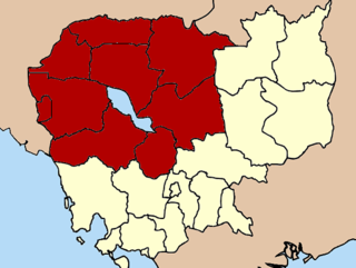
Banteay Meanchey is a province (khaet) of Cambodia located in the far northwest. It borders the provinces of Oddar Meanchey and Siem Reap to the east, Battambang to the south, and shares an international border with Thailand to the west. Its capital and largest city is Serei Saophoan.

Battambang is a province of Cambodia in the far northwest of the country. Bordering provinces are Banteay Meanchey to the north, Pursat to the east and south, Siem Reap to the northeast, and Pailin to the west. The northern and southern extremes of the province's western boundaries form part of the international border with Thailand. In addition, Tonle Sap forms part of the northeastern boundary between Siem Reap and Pursat. Its capital and largest city is Battambang.

Oddar Meanchey is a province (khaet) of Cambodia in the remote northwest. It borders the provinces of Banteay Meanchey to the west, Siem Reap to the south and Preah Vihear to the east. Its long northern boundary demarcates part of Cambodia's international border with Thailand. The capital is Samraong town.

Siem Reap, officially Siemreap, is a province (khaet) of Cambodia. It borders the provinces of Oddar Meanchey to the north, Preah Vihear and Kampong Thom to the east, Battambang to the south, and Banteay Meanchey to the west. Its capital and largest city is Siem Reap.
The Apostolic Prefecture of Battambang is a territorial subdivision of the Roman Catholic Church in Cambodia.
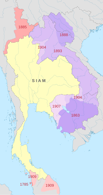
Siam Nakhon is the name of a former Thai province. It was a changwat (province) of Siam, but was ceded to French Indochina in 1907. The name of Siam Nakhon was later changed to Siem Reap in Cambodian.

Battambang or Krong Battambang is the capital city of Battambang province in northwestern Cambodia.

Phra Tabong Province was a province of Thailand, from the late-18th century until it was ceded to French Indochina in 1907, and again between 1941-1946 after Thailand recaptured it during the Japanese occupation of Cambodia in World War II. The province was dissolved and returned to France in 1946. The area is now in the Pailin municipality of Battambang Province, Cambodia.

Siem Reap is the capital city of Siem Reap Province in northwestern Cambodia.

Mongkol Borey District is a district (srok) in the south of Banteay Meanchey Province, in northwestern Cambodia. The district capital is Mongkol Borey town, around nine kilometres south of the provincial capital of Sisophon by road. Mongkol Borey District is the southernmost district of Banteay Meanchey. The district shares a border with Battambang Province to the south. The main railway line from Phnom Penh to Poipet on the border with Thailand runs through the district from north to south.

Preah Netr Preah is a district (srok) in the east of Banteay Meanchey Province, in north-western Cambodia. The district capital is Preah Netr Preah town located around 24 kilometres due east of the provincial capital of Sisophon by road. Preah Netr Preah District is one of the easternmost districts of Banteay Meanchey. The district shares a border with both Siem Reap Province and Battambang Province to the east and the south respectively. Two major watercourses, the Sangke River and the Mongkol Borei River run through the district.

Serei Saophoan is a district (srok) in the centre of Banteay Meanchey Province, in north-western Cambodia. Serei Saophoan is the urban district of Banteay Meanchey province and the district capital is also the provincial capital Sisophon town. The town is located 359 kilometres north of Phnom Penh and 48 kilometres from the border with Thailand at Poipet. Serei Saophoan District is the central district of Banteay Meanchey and is surrounded by other Banteay Meanchey districts. Cambodia's main railway line from Phnom Penh to Poipet enters the district from the south and exits to the west.

Thma Puok is a district (Srok) in the north of Banteay Meanchey Province, in north-western Cambodia. The district capital is Thma Puok town located around 42 kilometres north of the provincial capital of Sisophon by road. The district shares a border with Thailand to the west and Oddar Meanchey Province to the north east. No national highway runs through the district but national road 56 from Sisophon to Samraong in Oddar Meanchey province crosses the district from north to south. The district is home to the large temple complex of Banteay Chhmar. The temple was built in the late 12th or early 13th century by Jayavarman VII and is a modest tourist destination.
Svay Chek is a district (srok) in the north of Banteay Meanchey Province, in north-western Cambodia. The district capital is Svay Chek town located around 22 kilometres north of the provincial capital of Sisophon by road. The district shares a border with Thailand to the west. No national highway runs through the district but national road 56 from Sisophon to Samraong in Oddar Meanchey province crosses the district from north to south.

Phnom Srok District is a district (srok) in the east of Banteay Meanchey Province, in north-western Cambodia. The district capital is Phnom Srok town located around 52 kilometres north east of the provincial capital of Sisophon by road. Phnom Srok District is the easternmost district of Banteay Meanchey. The district shares a border with both Siem Reap Province and Oddar Meanchey Province to the east. There are no major roads within the district and it is quite isolated.

Ang Trapaing Thmor is a 129.06 km2 (49.83 sq mi) protected forest in northwestern Cambodia that was established in 1999. The reserve was set aside to protect the rare eastern sarus crane. Prior to the discovery of the crane at Trapaing Thmor, there were thought to be fewer than 1,000 of the birds left alive in the world.
Phibunsongkhram Province was a former province of Thailand that existed between 1941 and 1946. It was created as a result of the annexation of Cambodian territory by Thailand following the 1940-41 Franco-Thai war. This province was named after Plaek Phibunsongkhram, prime minister of Thailand at that time. The province was dissolved and returned to France in 1946.
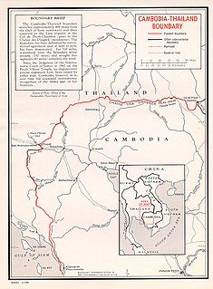
The Cambodia–Thailand border is the international border between Cambodia and Thailand. The border is 817 km in length and runs from the tripoint with Laos in the north-east to the Gulf of Thailand in the south.