Evidence for modern human presence in the northern and central highlands of Indochina, that constitute the territories of the modern Laotian nation-state dates back to the Lower Paleolithic. These earliest human migrants are Australo-Melanesians — associated with the Hoabinhian culture and have populated the highlands and the interior, less accessible regions of Laos and all of South-east Asia to this day. The subsequent Austroasiatic and Austronesian marine migration waves affected landlocked Laos only marginally and direct Chinese and Indian cultural contact had a greater impact on the country.

French Indochina, officially known as the Indochinese Union from 1887 and the Indochinese Federation after 1947, was a grouping of French colonial territories in Southeast Asia until its demise in 1954. It comprised three Vietnamese regions of Tonkin in the north, Annam in the centre, and Cochinchina in the south, Cambodia, Laos and the Chinese territory of Guangzhouwan. The capital for most of its history (1902–45) was Hanoi; Saigon was the capital from 1887 to 1902 and again from 1945 to 1954.
Sisavang Phoulivong was king of the Kingdom of Luang Phrabang and later the Kingdom of Laos from 28 April 1904 until his death on 29 October 1959.

Luang Phabang, or Louangphabang, commonly transliterated into Western languages from the pre-1975 Lao spelling ຫຼວງພຣະບາງ as Luang Prabang, literally meaning "Royal Buddha Image", is a city in north central Laos, consisting of 58 adjacent villages, of which 33 comprise the UNESCO Town Of Luang Prabang World Heritage Site. It was listed in 1995 for unique and "remarkably" well preserved architectural, religious and cultural heritage, a blend of the rural and urban developments over several centuries, including the French colonial influences during the 19th and 20th centuries.

Prince Phetsarath Ratanavongsa (Somdej Chao Maha Uparaja Petsaraj Ratanavongsa was the 1st Prime Minister of Luang Phrabang in French Laos from 21 August 1941 to 10 October 1945, and Head of State of Laos between 12 October 1945 and 4 April 1946.

The Franco-Thai War was fought between Thailand and Vichy France over certain areas of French Indochina.

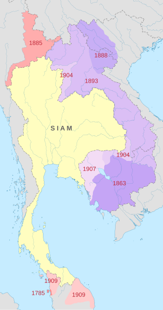
The French protectorate of Laos was a French protectorate in Southeast Asia of what is today Laos between 1893 and 1953—with a brief interregnum as a Japanese puppet state in 1945—which constituted part of French Indochina. It was established over the Siamese vassal, the Kingdom of Luang Phrabang, following the Franco-Siamese War in 1893. It was integrated into French Indochina and in the following years further Siamese vassals, the Principality of Phuan and Kingdom of Champasak, were annexed into it in 1899 and 1904, respectively.

Phra Tabong Province was a province of Thailand, from the late-18th century until it was ceded to French Indochina in 1907, and again between 1941-1946 after Thailand recaptured it during the Japanese occupation of Cambodia in World War II. The province was dissolved and returned to France in 1946. The area is now in the Pailin municipality of Battambang Province, Cambodia.
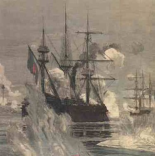
The Franco-Siamese War of 1893 was a conflict between the French Third Republic and the Kingdom of Siam. Auguste Pavie, French vice consul in Luang Prabang in 1886, was the chief agent in furthering French interests in Laos. His intrigues, which took advantage of Siamese weakness in the region and periodic invasions by Vietnamese rebels from Tonkin, increased tensions between Bangkok and Paris. Following the conflict, the Siamese agreed to cede Laos to France, an act that led to the significant expansion of French Indochina.
The Kingdom of Champasak or Bassac, (1713–1904) was a Lao kingdom under Nokasad, a grandson of King Sourigna Vongsa, the last king of Lan Xang and son-in-law of the Cambodian King Chey Chettha IV. Bassac and the neighboring principalities of Attapeu and Stung Treng emerged as power centers under what was later to be described as the Mandala Southeast Asian political model.
Thailand in World War II officially adopted a position of neutrality until the five hour-long Japanese invasion of Thailand on 8 December 1941 which led to an armistice and military alliance treaty between Thailand and the Japanese Empire in mid-December 1941. At the start of the Pacific War, the Japanese Empire pressured the Thai government to allow the passage of Japanese troops to invade British-held Malaya and Burma. The Thai government under Plaek Phibunsongkhram considered it profitable to co-operate with the Japanese war efforts, since Thailand saw Japan – who promised to help Thailand regain some of the Indochinese territories which had been lost to France – as an ally against Western imperialism. Axis-aligned Thailand declared war on the United Kingdom and the United States and annexed territories in neighbouring countries, expanding to the north, south, and east, gaining a border with China near Kengtung.
The Japanese occupation of Cambodia was the period of Cambodian history during World War II when the Kingdom of Cambodia was occupied by the Japanese. Vichy France, who were a client state of Nazi Germany, nominally maintained the French protectorate over Cambodia and other parts of Indochina during most of the Japanese occupation. This territory of Cambodia was reduced, by concessions to Thailand after the Franco-Thai War, so that it did not include Stung Treng Province, Battambang Province, and Siem Reap Province.

Kingdom of Vientiane was formed in 1707 as a result of the split of the Kingdom of Lan Xang. The kingdom was a Burmese vassal from 1765 to 1824. It then became a Siamese vassal until 1828 when it was annexed by Siam.

The Luang Prabang Range, named after Luang Prabang, is a mountain range straddling northwestern Laos and Northern Thailand. Most of the range is located in Sainyabuli Province (Laos), as well as Nan and Uttaradit Provinces (Thailand), with small parts in Phitsanulok and Loei Provinces. Several rivers such as the Nan, Pua and Wa rivers, have their sources in this range. Phu Fa waterfall, the biggest and the tallest waterfall in Nan Province, is also located in these mountains. This range is part of the Luang Prabang montane rain forests ecoregion.

Sainyabuli Province is a province in northwest Laos. Sainyabuli town is the capital of the province. Sainyabuli is the only Lao province that is completely west of the Mekong River.

Luang Prabang is a province in northern Laos. Its capital of the same name, Luang Prabang, was the capital of Lane Xang Kingdom during the 13th to 16th centuries. It is listed since 1995 by UNESCO as a World Heritage Site for unique architectural, religious and cultural heritage, a blend of the rural and urban developments over several centuries, including the French colonial influences during the 19th and 20th centuries. The province has 12 districts. The Royal Palace, the national museum in the capital city, and the Phou Loei Protected Reserve are important sites. Notable temples in the province are the Wat Xieng Thong, Wat Wisunarat, Wat Sen, Wat Xieng Muan, and Wat Manorom. The Lao New Year is celebrated in April as The Bun Pi Mai.
Phibunsongkhram Province was a former province of Thailand that existed between 1941 and 1946. It was created as a result of the annexation of Cambodian territory by Thailand following the 1940-41 Franco-Thai war. This province was named after Plaek Phibunsongkhram, prime minister of Thailand at that time. The province was dissolved and returned to France in 1946.
Nakhon Champassak Province was a former province in Thailand established in 1941 following the annexation of territories of French Indochina. The province was dissolved and returned to France in 1946.
The people of Laos have a rich literary tradition dating back at least six hundred years, with the oral and storytelling traditions of its peoples dating back much earlier. Lao literature refers to the written productions of Laotian peoples, its émigrés, and to Lao-language works. In Laos today there are over forty-seven recognized ethnic groups, with the Lao Loum comprising the majority group. Lao is officially recognized as the national language, but owing to the ethnic diversity of the country the literature of Laos can generally be grouped according to four ethnolinguistic families: Lao-Tai (Tai-Kadai); Mon-Khmer (Austroasiatic); Hmong-Mien (Miao-Yao), and Sino-Tibetan. As an inland crossroads of Southeast Asia the political history of Laos has been complicated by frequent warfare and colonial conquests by European and regional rivals. As a result, Laos today has cultural influence from France, Thailand, China, Vietnam, Burma, and Cambodia.