
The Allegheny River is a 325-mile-long (523 km) headwater stream of the Ohio River that is located in western Pennsylvania and New York in the United States. It runs from its headwaters just below the middle of Pennsylvania's northern border, northwesterly into New York, then in a zigzag southwesterly across the border and through Western Pennsylvania to join the Monongahela River at the Forks of the Ohio at Point State Park in Downtown Pittsburgh, Pennsylvania.

Jordan is a village in Onondaga County, New York, United States. As of the 2020 census, the population was 1,192. It is part of the Syracuse Metropolitan Statistical Area. It was named after the Jordan River.

Elbridge is a town in Onondaga County, New York, United States. As of the 2020 Census, the population was 5,476. The town is named after Elbridge Gerry, the fifth Vice President of the United States, and one of the signers of the Declaration of Independence.

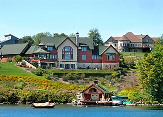
Skaneateles is an affluent village in the town of Skaneateles, in Onondaga County, New York, United States. The village is named after, and located on the shores of, Skaneateles Lake, one of the Finger Lakes. As of the 2020 census, the village had a population of 2,533 residents.
Skaneateles is a town in Onondaga County, New York, United States. As of the 2020 Census, the population was 7,112. The name is from the Iroquois term for the adjacent Skaneateles Lake, which means "long lake." The town is on the western border of the county and includes a village, also named Skaneateles. Both the town and village are southwest of Syracuse.

Skaneateles Lake is one of the Finger Lakes in central New York in the United States. The name Skaneateles means long lake in one of the local Iroquoian languages. The lake is sometimes referred to as "The Roof Garden of the Lakes" because its altitude is higher than the other Finger Lakes. It is one of the cleanest lakes in the United States.
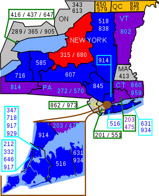
Area codes 315 and 680 are telephone area codes of the North American Numbering Plan (NANP) for the north-central area of the U.S. state of New York. Area code 315 was installed as one of the original North American area codes in 1947, while area code 680 was added to the numbering plan area (NPA) in an overlay plan in 2017.
The Skaneateles Turnpike was an east–west turnpike in central New York in the United States. It began east of the village of Skaneateles and ran east across southern Onondaga and Madison counties to Richfield Springs in northern Otsego County. The road began and ended at the Cherry Valley Turnpike, part of the Great Western Turnpike system, and largely paralleled the Cherry Valley Turnpike between Skaneateles and Richfield Springs. Most of the road is now county-maintained, but a handful of sections are now part of New York state touring routes.

The Seneca River flows 61.6 miles (99.1 km) through the Finger Lakes region of Upstate New York in the United States. The main tributary of the Oswego River – the second-largest river flowing into Lake Ontario – the Seneca drains 3,468 square miles (8,980 km2) in parts of fourteen New York counties. The Seneca flows generally east, and is wide and deep with a gentle gradient. Much of the river has been channelized to form part of the Erie Canal.

French Creek is a tributary of the Allegheny River in northwestern Pennsylvania and western New York in the United States.

Wawayanda Creek is the name of Pochuck Creek above its confluence with the tributary Black Creek. It is 17.0 miles (27.4 km) long. Wawayanda Creek, via Pochuck Creek, is a tributary of the Wallkill River in Sussex County, New Jersey in the United States. It starts northeast of Warwick, New York, and runs southwest, mostly within Orange County, flowing into New Jersey for several miles to its confluence with Black Creek just north of Highland Lakes, forming Pochuck Creek, which flows north back into New York.
Pochuck Creek is an 8.1-mile-long (13.0 km) tributary of the Wallkill River in Orange County, New York and Sussex County, New Jersey, in the United States.
Stony Creek is a 23.0-mile-long (37.0 km) tributary of the Susquehanna River in Dauphin County, Pennsylvania, in the United States.
Middle Creek is a 17.1-mile-long (27.5 km) tributary of Toms Creek in Pennsylvania and Maryland in the United States.

New York State Route 41 (NY 41) is a north–south state highway in Central New York in the United States. The southern terminus of the route is at an interchange with NY 17 in the town of Sanford in Broome County, New York. Its northern terminus is at an intersection with U.S. Route 20 (US 20) in the village of Skaneateles. The route is almost 100 miles (161 km) long and passes through Broome, Chenango, Cortland, and Onondaga counties. NY 41 was assigned as part of the 1930 renumbering of state highways in New York, replacing New York State Route 70 from Homer to Skaneateles. The route initially extended as far north as Jordan; however, NY 41 was cut back to its current northern terminus c. 1933.

New York State Route 174 (NY 174) is a state highway in Onondaga County, located in Central New York, in the United States. The highway is 16.7 miles (26.9 km) long and passes through mostly rural regions. Route 174 begins at an intersection with NY 41 in Borodino, a hamlet of Spafford. It heads generally northward for most of its length, except for short distances in the villages of Marcellus and Camillus. The route ends at a junction with NY 5 west of Camillus, at the west end of the Route 5 Camillus bypass. Route 174 is located along a large mapped sedimentary bedrock unit, known as the Marcellus Formation. The formation is named for an outcrop found near the town of Marcellus, New York, during a geological survey in 1839.

New York State Route 175 is an east–west state highway located entirely within Onondaga County, New York, in the United States. The 15.46-mile (24.88 km) route begins at an intersection with U.S. Route 20 (US 20) east of the village of Skaneateles and passes through the village of Marcellus before ending at a junction with US 11 in Syracuse. The highway was designated in the 1930 renumbering of state highways in New York.

New York State Route 317 (NY 317) is a 3.12-mile (5.02 km) long state highway within the town of Elbridge in Onondaga County, New York, in the United States. It begins at an intersection with NY 5 in the village of Elbridge and ends at a junction with NY 31 in the village of Jordan. The highway is known locally as Jordan Road and Main Street.
Jordan Creek is a 34.1-mile-long (54.9 km) tributary of Little Lehigh Creek in Lehigh County, Pennsylvania.

New York State Route 20SY (NY 20SY) was a state highway in the vicinity of the city of Syracuse, New York, in the United States. It connected U.S. Route 20 (US 20) to downtown Syracuse via Skaneateles, Camillus, Manlius, and Cazenovia in Onondaga County and Madison County. The highway began at an intersection with US 20 and NY 321 in the village of Skaneateles and ended at a junction with US 20, NY 20N, and NY 92 near the village of Cazenovia. Most of NY 20SY overlapped another route; however, two sections of NY 20SY—one in the town of Camillus and another near the village of Fayetteville—were not concurrent with another highway.


